
Archived Articles
Signs Of The Predicted Pole Shift
And Earth Changes
And Earth Changes
The First Two Signs, For The Beginning of the Changes
How soon?
Q) How soon will the changes in the earth's activity begin to be apparent? A) When there is the first breaking up of some conditions in the South Sea (that's South Pacific, to be sure), and those as apparent in the sinking or rising of that that's almost opposite same, or in the Mediterranean, and the Aetna [Etna] area, then we may know it has begun.
Q) How long before this will begin? A) The indications are that some of these have already begun, yet others would say these are only temporary. We would say they have begun. '36 will see the greater changes apparent, to be sure.
Q) Will there be any physical changes in the earth's surface in North America? If so, what sections will be affected, and how? A) All over the country we will find many physical changes of a minor or greater degree. The greater change, as we will find, in America, will be the North Atlantic Seaboard. Watch New York! Connecticut, and the like.
Q) When will this be? A) In this period. As to just when -
311-8; April 9, 1932
Referring to the reading above, are there any indications of "the first breaking up of some conditions in the south Pacific and those as apparent in the sinking or rising of that that's almost opposite same, or in the Mediterranean, and the Aetna [Etna] area? [I am assuming here that some conditions refers to some geophysical conditions.]
In my book, “Coming Earth Changes” (A.R.E. Press, 1996, on pages 54-58), I proposed that the seismically active Tonga Trench was probably the area of the South Pacific that is “almost opposite” the Mediterranean or Etna area. This area is the Earth's most active zone of mantle seismicity. Its seismicity arises from the subduction of the Pacific plate at the trench. About two-thirds of global deep quakes are located here. Also, as seen in Figure1, the Tonga Trench is located close to the point that is opposite to Mt. Etna in the Mediterranean area.
We will be referencing now four abstracts from Session 62C of the December 2002 meeting of the American Geophysical Union. They are abstract numbers S62C-1204 through 1208. No. 1204 begins by relating that “on August 19, 2002, two large deep earthquakes occurred about 7 minutes apart in the central and southern region of the deep Fiji-Tongan subduction zone, respectively. The second earthquake occurred at 680 km depth, and is, with a magnitude of M 7.7, the largest deep event in the Fiji-Tonga subduction zone ever [our emphasis] recorded".
Abstract No. 1207 states that the aftershock productivity of this second event was consistent with that of the M 7.6 quake of March 9, 1994. I had mentioned in my book (p. 55), citing D. Giardini and P. Lundgren (1995, GRL), that this 1994 quake suggested that a new mode of seismic deformation had become active in the northernmost termination of the Tonga-Fiji slab. It cut across the dense cluster of seismicity of the previous 30 years.
One asks if the August double quake in the Fiji-Tonga realm may have triggered the seismic rumblings in the Mediterranean and rising of the submerged island mentioned in the Reuters press release below. And could these events then have been followed by the robust new eruptions of Mt. Etna that began in October 2002? My answer is that this seems not to be the case, at least according to what geoscientists seem to know about Earth dynamics.
But what does seem possible, according to conventional geophysical understanding, is that both the sensitive Mediterranean (Etna) and Fiji-Tonga regions could be the first to reflect a global acceleration in the ongoing movements of Earth's tectonic plates. Such an acceleration would be in response to the strains produced in Earth's crust as the poles try to begin to shift.
Consider, then, these two reports from the vicinity of the Tonga Trench. D. Millen and M. Hamburger (Geology, 1998, v. 26, pp. 659-662) report that the Pacific plate is being torn through the entire thickness of the ocean lithosphere at the northern end of the Tonga Trench. (See Fig. 1). Their data reveal a process that is apparent to geologists familiar with this region.
C. Small and D. Abbott (Geology, 1998, v. 26, pp. 795-798) recently discovered a linear trough running east-west across the seafloor in the South Pacific. It “may mark the place where Earth's outer shell has started to tear, opening up one of the freshest wounds on the surface of the globe” (Science News, 9/5/1998, p. 151). Flanked by steep ridges, the seabed canyon lies about 1600 km north-northeast of New Zealand. The authors have named this feature the Louisville Trough (Fig. 1). Their report is entitled "Subduction obstruction and the crack-up of the Pacific plate," and their thesis is that coupling between a large subducting seamount and the overriding Australian plate may serve as a mechanism to focus stresses and nucleate a rift in the Pacific plate as it moves beneath (subducts) the Australian plate.
Are not the above two reports of the “breaking up of some conditions in the South Pacific” making “apparent” the “changes in the Earth's activity” referred to in reading 311-8?
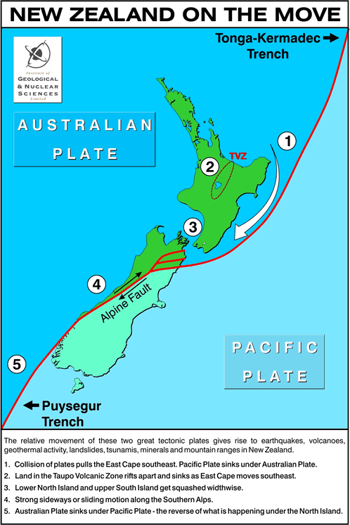
What about New Zealand?
New Zealand is located astride one of the world's major plate boundaries. Beneath the North Island the Pacific crustal plate is being subducted under the Australian plate. Southwest of the South Island, the Pacific plate (including the South Island) is overriding the Australian plate. Between these two opposing subduction systems the plate margins are in oblique collision, and the New Zealand landmass is being twisted and torn by complex horizontal faulting and vertical movements.
This slow breaking up of New Zealand is taking place in an area of the South Pacific that's also almost opposite to “the Mediterranean and Etna area.” Actually, the northeast coast of the North Island is slightly closer than the Tonga trench area to the point in the south Pacific (Fig. 1) that we just said was the most probable location of the South Sea breakup mentioned in reading 311-8.
Mt. Etna is located at 37.73º N, 15.00º E, and so the location in the South Pacific that is directly opposite Mt. Etna is at 37.73º S, 165.00º W, or about 1400 km (870 mi) due east of Gisbourne, on the North Island of New Zealand.
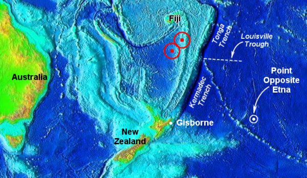 Fig. 1. Region of "breaking up" in the South Pacific that is "almost opposite" the Etna area in the Mediterranean. Locations of deep earthquakes (both M 7.7) of August 19, 2002 are shown by red rings.
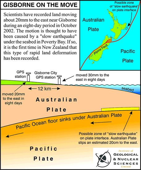
And so, what's going on in New Zealand relative to crustal movements just now? Here are two media releases from New Zealand's Institute of Geological and Nuclear Sciences Limited (GNS). The first deals with rapid horizontal motion of the crust in the vicinity of the northeastern corner of the North Island near Gisbourne.
Partial GNS News Release, 19 December 2002
Scientists Record Unprecedented Movement Of Land Near Gisborne
Scientists have recorded land near Gisborne moving about 20 mm to the east during an eight-day period in October.
The motion is thought to have been caused by movement on the boundary between two tectonic plates under the seafloor in Poverty Bay.
It is the first time that land deformation of this type has been recorded in New Zealand, although it has been observed above plate boundaries in other parts of the world in recent years.
The movement was recorded on two continuously-recording Global Positioning System (GPS) instruments, one of which was installed only five months ago, said Laura Wallace and John Beavan, geophysicists at the Institute of Geological and Nuclear Sciences Ltd (GNS).
One of the instruments is near the centre of Gisborne and the other is about 12 km west of the city.
The instrument west of Gisborne captures data from GPS satellites every 30 seconds and sends "packages" of data every hour to GNS data processing centres in Wellington and Wairakei, near Taupo. The instrument in Gisborne is run by Ian Bell, a local GPS operator.
In the months leading up to the event, the instruments showed that tectonic forces were pushing land at Gisborne slowly to the west by about 5 mm-a-year.
" It's almost like land around Gisborne sprung back slowly to the east to relieve some of the stress it was under," Dr Beavan said.
" We routinely see horizontal movement of land in numerous parts of New Zealand of 20 mm or more a year. But to see that amount of movement in eight days is extraordinary."
The sloping boundary between the Pacific and Australian tectonic plates is located about 15 km below Gisborne and gets shallower offshore in Poverty Bay.
Earthquakes occur occasionally at plate boundaries throughout the world as the two plates stick together for many years and then suddenly slip past each other.
Scientists believe that the movement at Gisborne may have been caused by a "slow earthquake" where the two sides of the plate interface slipped past each other by about 20 cm. However, the slip took place much more slowly than in a normal earthquake, so did not cause the shaking and damage of a normal quake.
"At this stage, all we can say for certain is that an unknown area of land on the North Island's east coast moved quite rapidly to the east by about 20 mm during mid-October. With more GPS stations in the North Island, we'd be able to say with more certainty how much of the North Island was affected," Dr Beavan said."
The second GNS media release deals with vertical motions of the Taupo volcano region, also on the North Island. Taupo is a volcano that is one of the potentially super-eruptive volcanoes that we monitor weekly. (See THC Earth Change News page.) Note especially the pulsation of the Taupo volcanic area described in the media release. It seems to compare to the pulsation in the Mediterranean/Etna area that will be revealed later on.
Relative motions of the plates beneath New Zealand have produced a rugged topography and active volcanoes. North Island's Ruapehu volcano exploded spectacularly in September 1995. Ruapehu is the major ski resort of the island, attracting 10,000 skiers on some days. But the eruptions that continued into October 1995 produced mud flows, emptied a large lake, and dispersed a large volume of ash and scoria bombs downwind.
As for earthquakes, a 1848 temblor was violent on both sides of the Cook strait, and resulted in fissures and fresh scarps in the Atwatere Valley. Wellington, the capital, was seriously damaged in the quake of 1855, and country to the west was generally uplifted from three to ten feet.
Partial GNS Media Release, 6 June 2002
Taupo Rising And Falling Faster Than Other Parts Of New Zealand
Parts of the Taupo region have risen and fallen by up to 7 centimetres over 10 years, scientists have found in a long-term study of the area.
The vertical movements, or deformation, are a direct result of Taupo's location which spans an active caldera volcano and a volcanic rift system where tectonic forces are pulling the earth's surface apart by several millimetres a year.
Published in the New Zealand Journal of Geology & Geophysics, the report is a summary of data from 22 measuring stations around the edge of the 600 sq km lake, and along a belt of active faults north-east of Taupo Although vertical movement data from other parts of New Zealand is sparse, it is thought that movements at Taupo are probably unrivalled in their rates and complexity.
Volcano surveillance co-ordinator, and joint author of the report, Brad Scott, said the data showed parts rising steadily for several years then stopping abruptly, and sometimes even reversing direction.
Mr Scott said the observations provided a valuable insight into the underlying dynamics in a region undergoing "continuous extension, frequent earthquake swarms, and occasional volcanism."
Scientists observed four distinct periods of deformation during the 20-year study. The first was a four-year phase when they observed steady subsidence in the Taupo Fault Belt, north-east of Taupo.
The second episode started in 1983 and consisted of rapid uplift in the Taupo Fault Belt. During the third phase, between 1984 and 1996, the Taupo Fault Belt subsided again at an average rate of 11mm a year.
The final episode, between 1996 and 1999, featured uplift at the south-east shores of Lake Taupo.
Summary for the "break-up" of conditions in the South Pacific
If the motions of Earth's tectonic plates are beginning to respond to an approaching pole shift, we should definitely be able to see the consequences of such activity now. The consequences should be “apparent,” to use the word as found in 311-8, first in seismically and tectonically sensitive places like New Zealand and the Tonga trench regions near the point almost opposite Mt. Etna. On the opposite side of the planet, in the Mediterranean and the Etna areas, we should expect to see evidence of horizontal plate acceleration, or vertical-crustal-motion effects in the pulsation of the sea-floor off Sicily or in the rising or sinking of lands in and surrounding Sicily.
There would be nothing quite so convincing of the predictive strength of reading 311-8 as observing an island rising out of the Mediterranean Sea in the Etna area, while at the same time perceiving the break-up of geological conditions in the South Pacific. Read the next section and see if you don't agree that "the changes in the Earth's activity" have “begun to be apparent.”
And realize, too, that when reading 311-8 was given nobody had the foggiest idea about such concepts as plate tectonics, mantle seismicity, or the host of other tools that geoscientists so routinely use today. That's why it has taken so long for us to be able to appreciate the “apparent” nature of reading 311-8 just today. This seems to be a bit like the Bible Code. The messages have always been there, encoded in the text, but it has taken until now, with the development of computerized search procedures, for those messages to become apparent to mankind.
Sinking or rising in the Mediterranean and the Etna area.
On pages 50-54 of Coming Earth Changes, attention is given to recent sinking and rising of the crust in the Etna area, as reported by scientists up to 1996. This includes evidence that "both the volcano and northeastern Sicily have been uplifted 1.5 mm/year during Holocene times [the last 10,000 years], although more recent rates of uplift may have been greater." (Firth, C., and Others, 1996, Geol. Soc. Spec. Pub, No. 110).
Some commentators on the readings confuse Etna's recent spectacular eruptive activity of the past few years with "sinking or rising" in the Etna area. But while the recent magma pumping does cause the volcano to inflate (swell slightly) and to deflate temporarily, and while lava flows add somewhat to the elevation of Etna's slopes, these changes do not relate to the broader "Etna area" mentioned in the reading. Also, the wording of reading 311-8 seems to require that vertical crustal movements in the vicinity of Etna must become more obvious before we can truly say that significant Earth changes are imminent.
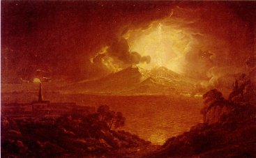
Such obvious accelerated sinking or rising of the crust in the immediate Etna area has indeed begun. The Campi Flegri caldera, in southern Italy, also called the Phlegraean Fields, is one of the major calderas in the world undergoing unrest. (See Fig. 2). Several hundred thousands of people live within its borders. This makes for a high volcanic risk from even a minor eruption. The caldera was formed as a consequence of a huge eruption around 40,000 B.P.
Over the last ten thousand years, volcanic activity has been characterized by the occurrence of explosive eruptions thousands of years apart. The last one occurred in 1538. The base of the caldera had been sinking at an average speed of 1 cm per year, from 1538 until 1970. Two resurgence episodes occurred in 1970-1972 and 1982-1984, producing uplift with a maximum of about 3.8 m at the town of Pozzuoli. Then, the ground began to sink again, and is sinking now. This volcanic area is close to Mt. Vesuvius and Naples (Napoli.). See Figure 2.
 Fig. 2. Location of the restless caldera volcano, Campi Flegri, at Pozzuoli just west of Naples (Napoli). The impacts of the 79 A.D. eruption of Mt. Vesuvius are shown, as modified from Fig. 4-3 of J. Boer and D. Saunders, 2002, Volcanoes in Human History.
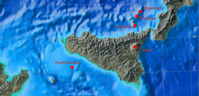
Near Etna -- A Sunken Isle Is Rising!
Partial Press Release
November 25, 2002
ROME, Italy (Reuters) -- A volcanic island submerged off the coast of Sicily for the last 170 years could reappear in the coming weeks if furious seismic rumblings continue, Italy's chief seismologist said Monday.
"We've seen Etna erupting, seismic activity to the north and east of Sicily and gas activity around the Aeolian Islands," Enzo Boschi, head of Italy's Institute of Geophysics and Volcanology, said.
"The island could come back to the surface, but we'll have to wait and see. It could be a few weeks or months."
Figure 3 below shows graphics and pictures that tell more about the location and nature of Ferdinandea, the island that is reported to be rising:
 Map generated with Jules Map server featuring GMT and Face of the Earth
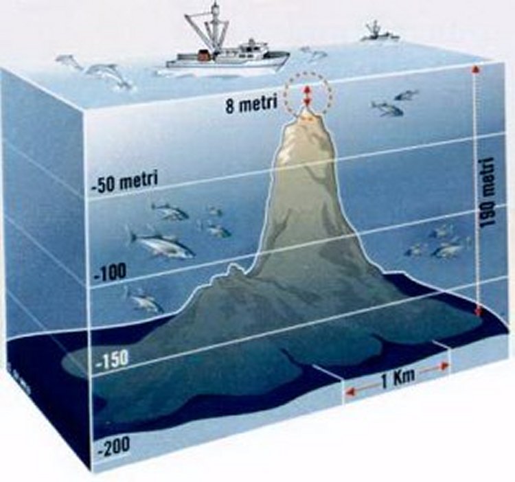 Drawing from L'Espresso n° 18, maggio 2000
 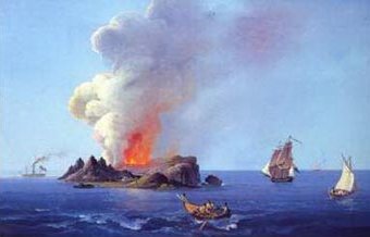 Historical painting of Ferdinandea island.
 Fig. 3. Map showing the location of the submerged isle of Ferdinandea, an artist's conception of it, and an historical painting of the island in 1831.
Note that in my analysis of 311-8, in “The Sources and Veracity of Edgar Cayce's Readings, Part 2,” I concluded that, “The Earth-changes information in the reading fragment cited is probably for the most part truthful, and it has predictive capability that may be trusted.”
But consider once again this part of reading 311-8:
Q) How long before this will begin?
A) The indications are that some of these have already begun, yet others would say these are only temporary. We would say they have begun. '36 will see the greater changes apparent, to be sure.
When I wrote Coming Earth Changes (in 1996) I assumed that the date of '36 (1936) was correct, and tried to explain the apparent absence “of greater changes apparent” in the following way (p. 50):
The reference to " '36 will see the greater changes apparent" can be handled in the same way that the subject of Earth changes in 1936 was dealt with in Chapter One; that is, the main geophysical events of 1936 were stated in reading 5748-6 to be "the upheavals in the interior of the Earth." And the phrase, the greater changes apparent, probably refers to events in the interior of the Earth that would be apparent to the psychic source that communicated reading 5748-6, and also, perhaps, 311-8. To be apparent at the Earth's surface would imply perception of observable shifts in the rates and/or intensities of ongoing seismic or tectonic activities. It would take a lengthy literature search to detect any such shifts in surficial seismo-tectonic patterns as having occurred in 1936. A cursory check shows nothing out of the ordinary.
Thus, we have a predicament. The changes may have been too subtle for us to detect, they may have been hidden from view because they were upheavals in the interior of the Earth, or the date of 1936 may reflect “wavered” information as received by Cayce's conscious mind. Then again, Cayce's source for that date (the spirit entity Demitrius?) may have simply been wrong.
Volcanoes With Indicator Functions
For Coming Earth Changes
Two specific volcanoes are mentioned in the Cayce readings as having what can be called "indicator" functions. Such functions are for warning people of upcoming, historically unprecedented Earth changes.
Mt. Vesuvius, in Italy, and Mt. Pelée, on the Caribbean island of Martinique (or, alternatively, Kilauea on Hawaii), are to be watched for "greater activities." When such activities occur at one or the other of these volcanoes, they will indicate that the southern coast of California -- and areas between Salt Lake and the southern portions of Nevada -- will experience, within three months, "an inundation by the earthquakes." (270-35, 1/21/36)
In addition to the above two volcanoes, a reading obtained from archangel Halaliel mentions that volcanoes situated in Earth's torrid areas will erupt just prior to a "shifting of the poles." Thus, when more than the expected numbers of torrid-area volcanoes begin to erupt, their collective activity will indicate that a pole shift - predicted in Cayce reading 3976-15 -- is to occur soon thereafter.
A review of the current eruptive status of these indicator volcanoes seems appropriate at this time. Reading 1602-3 said that, beginning in 1998, the Earth "may find a great deal of the activities as have been wrought by the gradual changes that are coming about." Thus, we need to propose criteria for distinguishing between the normal activities of these volcanoes and the sort of behavior that indicates unambiguously that their indicator functions are being fulfilled.
Eruptions of Vesuvius and Pelée (or Kilauea), And "Inundations" By Earthquakes
The purpose of one or the other(s) of these indicator volcanoes is to provide a warning of impending earthquakes and "inundations" in parts of California, Utah, and Nevada, and in the southern hemisphere.
If there are the greater activities in the Vesuvius, or Pelée, then the southern coast of California -- and the areas between Salt Lake and the southern portions of Nevada – may expect, within three months following same, an inundation by the earthquakes. But these, as we find, are to be more in the Southern than in the Northern Hemisphere.
270-35, January 21, 1936
There are two possible ways of interpreting the "inundations-by-the-earthquakes" language of this reading. Conventional interpretation of the phrase has been that it is a figure of speech for "an overwhelming number of earthquakes." But a credible case can be made also for earthquake-induced flooding of the areas referenced in the reading. For example, a recent analysis (Chang, W. and R. Smith, 1996, AGU Fall Meet. Proc., Abstr. No. S31C-6). of the earthquake hazard in the Salt Lake City area, by two seismologists at the University of Utah, suggests a different interpretation. These researchers modeled land- deformation effects of a hypothetical, magnitude 7.2 quake that could be expected to occur on the south Weber segment of the north Salt Lake City segment of the Wasatch Fault. The seismologists put into their model a "scenario quake" consisting of the same ground-surface deformations that were observed in the M 7.5, 1959 Hebgen Lake, Montana, quake that occurred 270 miles north of Salt Lake City. They concluded:
"..... an unusual earthquake hazard [exists].....due to possible flooding and inundation [emphasis added] by the Great Salt Lake accompanying large normal-faulting earthquakes on the Wasatch Fault. .....Because of the close proximity of the Great Salt Lake to Salt Lake City, we demonstrate that this unappreciated hazard is very important, depending upon the lake level and the location of the scenario earthquake."
The changes implied by reading 270-35 above would involve far more than the isolated-earthquake, land-deformation, and flooding scenario modeled by the Utah scientists. Our new interpretation of reading 270-35 is that catastrophic earthquakes and flooding may occur in the land areas around Great Salt Lake and Utah Lake in Utah, around and below Lake Mead in far southern Nevada, and along those land areas fronting the Pacific Ocean in southern California. Such aqueous inundations could directly or indirectly affect population centers like Bringham City, Salt Lake City, Murray, Orem, and Provo in Utah, Las Vegas in Nevada, and the cities of coastal California from Santa Barbara south to San Diego.
Thus, we now have two ways of interpreting the "inundation-by-the-earthquakes" language of reading 270-35. And the ambiguity of the phraseology used seems to have allowed science to catch up to the reading, here just after the end of the 40-year period (1958 to 1998) said to be prelude to catastrophic Earth changes between 1998 and 2998. As if to bolster our interpretation at this critical time, there is new global-scale seismic-tomography evidence for deep mantle circulation of unprecedented proportion.
There's no question that the language of the readings can be quite challenging at times, as outlined in the examples above. But in continually trying to understand, we may in fact get understanding, often in unexpected ways. Here, recent scientific findings are accommodated by seemingly obscure phrases in the readings, many years after Cayce gave them.
Were certain of the readings intentionally constructed this way? If so, we may have insight here from the promise that, "In 1998 we may find a great deal of the activities as have been wrought by the gradual changes that are coming about....[and] ....as has been indicated, we will begin to understand fully in '98". (1602-3)
What are the chances of "an [aqueous] inundation of the southern coast of California" due to earthquakes, as just discussed? Have there been any earthquakes and associated tsunamis (seismic sea waves) there before? Yes, indeed.
But first, just what are tsunamis? (The word is Japanese for tsu harbor + nami wave, and in strict Japanese the word is both singular and plural. But we see the word so often in English as tsunamis, for more than one tsunami, that I will yield and follow this corruption, along with others).
A tsunami (pronounced tsoo-nah-mee) is a series of waves, generated in a body of water by an impulsive disturbance that vertically displaces ocean water. Sea-floor movements accompanying earthquakes are the most common cause of tsunamis. But landslides into the sea, submarine landslides, explosive submarine volcanic eruptions, and even meteorite impacts can generate tsunamis. Locally-generated tsunamis are the greatest threat to U.S. coastlines, but tsunamis originating at a distance are also a constant threat.
The U.S. has suffered damage from tsunamis originating in Chile, Japan, Russia, and Alaska. Eventually, tsunamis will strike all U.S. Pacific Ocean coastlines. Because reading 270-35 above seems to refer to tsunamis generated by local earthquakes, we will cite details for several here to give the reader an idea of historical numbers and effects. As covered in Tsunamis Affecting The West Coast of the United States: 1806-1992,1 the Santa Barbara tsunami of December 21, 1812, was most probably caused by a submarine landslide in the Santa Barbara basin. This landslide was believed due to an earthquake estimated at M7.7, and originating on the San Andreas Fault. The maximum wave height was about 15 feet or so, and is said to have reached half a mile inland. Submarine landslide tsunamis in California typically have waves with a maximum amplitude of 10 feet and affect a very restricted area. The tsunami of November 4, 1927, was such a one, and affected about 35 miles of shoreline. It was recorded as a six-foot wave at Surf, just north of Pt. Arguello near Santa Barbara, and as a five-foot surge at Port San Luis. Near Los Angeles, on July 10, 1855, four earthquakes generated a "probable submarine landslide and local tsunami." On May 27, 1862, an M5.9 earthquake at San Diego caused the only local tsunami observed there. On August 30, 1930, a M5.2 earthquake caused a 20-foot wave at Santa Monica, Venice, and Redondo Beach: "Probably a submarine landslide source given the low magnitude of the earthquake and localized effect. Sixteen people were rescued from the surf. One drowned at Redondo Beach." These few representative records show that local tsunami inundations "by [the] earthquakes" are quite possible for the southern coast of California.
In all, some 21 locally generated tsunamis of various destructive power have been documented for the southern California coast between 1806 and 1992. Although this coast seems safe from locally generated tsunamis relative to the coasts of, say, Japan or Alaska, the dangers from large tsunamis cannot be ignored.
D. S. McCullough, in a U.S. Geological Survey report on tsunamis along the Pacific coast, says that "a preliminary appraisal of the potential for locally generated tsunamis suggests that wave run-up heights as great as four to six meters," or 13 to 20 feet, could be caused by seabed movements due to earthquakes. Such waves are not in the same league with the giant tsunamis that hit Hawaii in 1946 and 1975, but even a five- or six-foot tsunami can cause widespread damage in a harbor or along a heavily settled stretch of coastline.
One tsunami-prone area in southern California is located off Santa Barbara where the offshore area has created an odd set of conditions with the potential for making large seismic sea waves. Quoting a report on southern California's tsunami potential, D. Ritchie says in his book Superquake! (Crown, NY, 1988), "Surface fault rupture accompanied by sea-floor displacement is a distinct possibility beneath the Santa Barbara Channel. To put it another way, a big quake on land could set off another quake under the sea and thus send tsunamis rolling toward the California shore." Support for this view is found in J. Deng and L. Sykes's recent study of the 200-year evolution of the crustal stress field in southern California (Jour. Geophysical Research, v. 102, B5, May 10, 1997). The authors write: "Future great earthquakes along the San Andreas Fault, especially if the San Bernardino and Coachella Valley segments rupture together, can trigger moderate to large earthquakes in the Transverse Ranges, as appears to have happened in the Santa Barbara earthquake that occurred 13 days after the great San Andreas shock of 1812."
We note in passing that another kind of inundation that could occur would be due to flooding by reservoir waters released when earthquakes cause dams to fail. Several stream-dammed reservoirs are located in the coastal zone of southern California.
If the ultimate cause of the tsunamis mentioned in our speculation on the meaning of 270-35 above is an acceleration of lithospheric plate movements incident to pole shift, there is one last, far-out possibility to consider. And it ties into the last sentence of the reading, which indicates that the effects of the inundations by the earthquakes will be felt more in the southern hemisphere.
This understanding of the phrase "inundations by the earthquakes" would relate to tsunamis generated from distant sources. If a huge piece of the Kilauea volcano, on the island of Hawaii, suddenly slides into the Pacific, highly energetic tsunamis would be generated that would strongly impact the southern California shoreline and those of Central and South America. Indeed, the coast of southern California has experienced no less than 44 tsunamis generated by earthquakes or submarine landslides beyond the U.S. Pacific coast (excluding Alaska) between 1806 and 1992. These waves have traveled from Japan, coastal Alaska, Chile, the Kuril Islands, the Java Sea, El Salvador, and other places. Many of the 44 tsunamis of distant origin that hit the coast of southern California were recorded only as minor excursions on tide-gage records.
But consider what could happen as accelerating mantle motions cause earthquakes and landslides at currently erupting Kilaeua. (The seismic hazard for the southern portion of Hawaii rivals that of the area around the San Andreas Fault in California, according to F. Klein, seismologist with the U. S. Geological Survey. And geophysicists in early 1997 were measuring progressive seaward displacements of the land portion of Kilauea's southeastern flank).
First, note that the tsunami of December 21, 1812, mentioned above traveled all the way from Santa Barbara, California, to Hookena, Kona, Hawaii, where the wave run-up height was estimated at between six and 14 feet. Now let's reverse the California-to-Hawaii tsunami travel direction. Suppose that a giant submarine landslide occurs on the southeastern flank of Kilauea and generates a large tsunami. The coastlines of Peru and Chile would receive the brunt of such a tsunami, but the coast of southern California would also be affected. Recall the words of reading 270-35, "But these [inundations by the earthquakes] are to be more in the southern than in the northern hemisphere."
How close is southeastern Kilauea to shedding enough material to produce a tsunami-generating submarine landslide? A. Hooper, and Others (2002 “Reconciling seismic and geodetic models of the 1989 Kilauea south flank earthquake,” Geophys. Res. Letters, v. 29, no. 22, pp. 19-1 to 19-4) examined seismic and geodetic models for the M 6.1 earthquake that struck Kilauea's south flank on June 26, 1989. Figure 4 shows a map view of the location of Kilauea's East Rift Zone, and Fig. 5 shows an elevation view of transect A-A' shown in Fig. 4.
 Fig. 4. After Figures 1 and 2 of A. Hooper, and Others' paper. The map of southeastern Kilauea shows the rift zone, the earthquake's epicenter, and the transect along which the cross-section (Fig. 5) was constructed. The green arrows represent the rate of displacement of the southeastern Kilauea coastal area seaward of the east rift zone as measured by GPS stations.
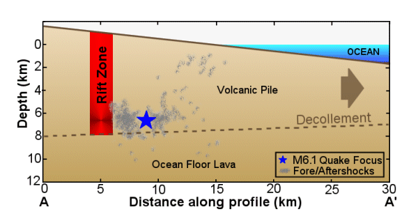 Fig. 5. Showing the earthquake of June 26, 1989, as being projected onto cross-section A-A' of Fig. 4. Also shown are the foci of the many foreshocks and aftershocks of the M 6.1 quake. The large brown arrow provides a sense of the movement of the volcanic rock above the decollement (see text).
The rift zone in Figs. 4 and 5 marks a system of fractures in the volcanic material of the southeastern slope of Kilauea. It has developed as a result of an incipient sliding motion of the volcanic materials on the ocean side of the rift zone. The decollement of Fig. 5 marks a structure of strata that results in independent styles of deformation in the rocks above and below. “It coincides with the interface between the volcanic pile and the pre-volcanic seafloor” (Hooper and Others, 2002). This southeastern flank of Kilauea “is moving south-southeast relative to the Pacific tectonic plate by about 8 cm/yr.” Many authors believe that sliding along the basal decollement just described accommodates this movement. At least one researcher, however, demonstrated that some slip occurs at a shallower depth.
The message to take away from the above information is that there is a strong likelihood that the southeastern flank of Kilauea will someday slide into the sea, producing an energetic tsunami that will be directed to the coast of southern California and to the relevant coastlines of the southern hemisphere. The crustal disturbances “by the earthquakes” mentioned in reading 270-35, could be assumed to be the trigger for the landslide, and the inundations from it would include the” inundation” to the southern coast of California.
 Fig. 6. Adapted from Fig. 2-2 of Volcanoes in Human History, showing the extent of submarine landslides resulting from gravitational collapse of large segments of volcanoes.
In their study, "Giant Hawaiian Landslides" (Annual Reviews of Earth and Planetary Science, 1994), J. Moore, and Others, document dozens of major landslides that have recently been discovered on the flanks of the Hawaiian Ridge. "They are among the largest on Earth, attaining lengths greater than 200 km and volumes of several thousand cubic kilometers." The authors write that rapid movement of some of the submarine debris avalanches "is indicated by the fact that some have moved uphill for tens of kilometers, and are believed to have produced major tsunamis."
Just What Is Meant By "Greater Activities" Of Indicator Volcanoes?
If there are the greater activities in the Vesuvius, or Pelée, then the southern coast of California -- and the areas between Salt Lake and the southern portions of Nevada – may expect, within three months following same, an inundation by the earthquakes. But these, as we find, are to be more in the Southern than in the Northern Hemisphere.
270-35, January 21, 1936
Just what "greater activities" means involves a somewhat subjective judgment. Greater than what other activities?
Vesuvius. When reading 270-35 was given in 1936, Vesuvius had been erupting intermittently for 23 years (since 1913). It continued to do so until 1944. Apparently, eruptions between 1936 and 1944 were not sufficient to qualify as "greater activities," because the "inundation by the earthquakes" did not occur. Volcanic activity during the 1936-1944 period was generally confined to the summit and upper slopes of Vesuvius.
Thus, "greater activities" at Mt. Vesuvius will be interpreted here to mean the occurrence of more vigorous and widespread eruptions than those that occurred between 1913 and 1944. Such stronger eruptions will presumably reflect the beginning of worldwide movements in Earth's lithospheric plates, associated with the beginning of a shift in the poles predicted for 2000 - 2001. Note that we have posted an article, Possible Pole-Shift Precursor Found!, that supports the notion that there is evidence that this pole shift may indeed have begun in 2000 to 2001.
Mt. Vesuvius (Fig. 2), located on the outskirts of Naples, Italy, last erupted in 1944. Nothing special is going on at this indicator volcano, or in its immediate area, at the present time. Mt. Vesuvius is a cone-shaped edifice built within a very old caldera2, Mt. Somma. The 18,000-year-old Mt. Somma caldera lies just east of another ancient caldera, Campi Flegrei. Thus, "the Vesuvius [realm or area?]" of the above reading comprises a highly volcanic portion of the Earth's crust.
The Mt. Nuovo eruption of 1538 A.D., which occurred in the Campi Flegrei caldera, is extremely interesting from the standpoint of reading 311-8. That reading speaks of "sinking or rising in the Mediterranean and the Etna area," and here follows just such an example for the Mediterranean area. It occurred within historical times, only 220 miles to the north of Mt. Etna. The eruptive events surrounding construction of Mt. Nuovo also provide an excellent example of the type of "greater activities" that might be expected in "the Vesuvius" of reading 270-35 above. (We ask again, did Cayce's psychic source mean "the Vesuvius [realm]"? Mt. Nuovo is only 16 miles from Mt. Vesuvius).
On September 29, 1538, an eruption began in Campi Flegrei that in one week built a cone-shaped volcano, Mt. Nuovo. The eruption was preceded by a period of uplift in the area that ended a 1,400-year period of sinking. Emergence of new land from places formerly occupied by the sea was first noted in 1502 by residents of Pozzuoli, a coastal town some 15 miles from Vesuvius. By the early 1530s, this uplift was accompanied by unusual seismicity. In September 1538, earthquakes increased dramatically and a remarkable rising of the seafloor displaced the coastline by several hundred feet in the area just west of Pozzuoli. Some sources mention an uplift amounting to about 23 feet. On September 29, a crack opened in the area of maximum uplift. This newly opened vent began to emit vast amounts of pumice, fire, and black and white smoke. Ash from the initial activity fell over a wide area. The bulk of the new cone was built during the first 24 hours and, when first climbed on October 2, a "boiling" lava lake was observed within the crater.
These observations provide a splendid historical record of "greater activities" in a volcanic area only 16 miles from Mt. Vesuvius; that is, in "the Vesuvius [area]" of reading 270-35. And they also provide an example of "sinking or rising....in the Mediterranean area." Again, Mt. Nuovo is only 220 miles from Mt. Etna. Thus, vertical crustal movements at Campi Flegrei today could perhaps qualify as occurring "in the Mediterranean and Etna area." Well then, note the following. Two important episodes of ground-surface uplift occurred in the Pozzuoli area in 1970-1972 (+5.6 ft) and in 1982-1984 (+6.0 ft). Sinking of the land surface has occurred since the end of 1984.
I speculate that something like the intensity of volcanic activity exemplified at Campi Flegrei in the 1530s will have to be repeated in the Vesuvius area today before we can assume that earthquakes and inundations will strike portions of Utah, Nevada, and coastal southern California within three-months' time. Recently, seismicity at Vesuvius during 1995 and 1996 was the strongest in the last 50 years. This indicates movement of subsurface magma. And at Campi Flegrei, increased temperatures have been noticed at vapor-emitting vents.
We continue to watch and wait for increased activities at Mt. Vesuvius proper, or in the Vesuvius area, if that's the way that "the Vesuvius" is to be interpreted. Then again, perhaps it is Mt. Pelée, rather than Mt. Vesuvius that is destined to be the indicator volcano that will trigger the three-month's warning for people living in the areas mentioned in reading 270-35 above.
Pelée or Pele? For the last 70 years Mt. Pelée has rested dormant on Martinique, an island in the Lesser Antilles of the Caribbean Sea. Pelée shows no signs of life today. Its reputation as a violent, killer volcano must have been quite familiar to Cayce when he gave reading 270-35 in 1936.
The May 8, 1902 eruption of Mt. Pelée killed around 28,000 people when a catastrophic nuée ardente, or glowing avalanche of hot gasses and particles, overwhelmed St. Pierre. So hot was this cloud that it melted the master cathedral bell and set fire to ships in the harbor. In August of the same year, Pelée also destroyed the town of Morne Rouge, killing close to 1,500 people. Closer monitoring of the volcano's activities helped prevent further deaths during the most recent eruptions of 1929 to 1932.
Treated on pages 267-268 of “Coming Earth Changes” is the possibility that Gladys Davis, Edgar Cayce's stenographer for reading 270-35, might not have known that Cayce's source could have meant "Pele," instead of Pelée. Pele could be interpreted to stand for the domain of the Polynesian fire goddess Pele, who mythically speaking is believed to inhabit the crater of Kilauea volcano on the island of Hawaii. Inspection of the original copy of reading 270-35 indicates that Mr. Cayce's source did not spell out either Pelée or Pele when giving his reading. Thus, perhaps the source did not mean Mt. Pelée, on the island of Martinique.
There is only a small difference in pronunciation, and just one letter “e” between the two names. Also, there is the unusual placement of the article “the” in, "If there are the greater activities in the Vesuvius, or Pelée." It seems as though a noun such as "areas" or "realms" has been omitted after the word Pelée. Thus, something like "....greater activities in the Vesuvius or Pele realms or areas....." might have been intended by the source of Cayce's reading.
I only recently learned that I was not the only one to have thought about the above possibility. It seems that Pluma Beck, a long time A.R.E. member and current resident of Hawaii, was so concerned about the Pelée/Pele matter that, sometime in the mid-1980s, she asked Gladys Davis about her recollection of the reading. Here is Ms. Beck's story.
Kilauea is a volcano in Hawaii on what is known locally as the Big Island. For the last twenty years the mountain has been constantly spewing lava. In January 2003 local volcanologists held a sort of birthday party, allowing visitors to tour through their labs for the first time as a commemoration of the lengthy eruption.
Ancient Hawaiians were in awe of the power and force of the volcano. They saw divine influence in all things in nature and so the god of the volcano must be a very powerful, very forceful god. They called her the Goddess Pele. From her name come words that mean lava flow, volcano, eruption, lava rock, or earth rock. There are legends built about her love and protection of her home, Kilauea that are still growing. Even modern day tourists sometimes learn strident lessons about her regard for her mountain home. She does not like for one piece of lava to be removed from her home and stories circulate about tourists who pick up and take home a souvenir only to sent it back and ask that it be put back on the mountainside.
I became keenly aware of the Goddess's love for her home in 1984. I had been working at the Association of Research and Enlightenment for nine years in the Readings Research Department. During that time there was thought to have been a marked increase in seismic activity around the globe. Hugh Lynn Cayce had asked me to put together a Circulating File of readings excerpts relating to earth changes in order to satisfy all the questions coming to his office from members of the association. This assignment grew to lectures and spurred my interest in the whole subject of geologic phenomena, particularly earthquakes.
In November of 1984 I spent Thanksgiving with my daughter and her family on O'ahu. One morning the daily newspaper sported large black headlines that read, "Who Made Madame Pele Angry?" My daughter and I were discussing this as we prepared dinner. I was quoting the Edgar Cayce readings that I had researched and referred to the similarity between Pelée in the readings and the Goddess Pele whose home was Kilauea.
The newspaper story related increased activity at one of Kilauea's craters. As we discussed this my seven-year-old grandson came in and wanted to correct something I had said.
I was pronouncing the Goddess's name the same as we pronounce the name of the volcano on the Caribbean island of Martinique. I gave it the French pronunciation "pay-lay". My grandson told us that this was not the way the Goddess was named. From the way my grandson pronounced her name, I realized that he was saying Pele with a short "e" sound. It was more like "eh" than a long "a". He told us that a Hawaiian lady had come to his class at the Waldorf School and had talked about the goddess and the mountain. He was very sure about the correct pronunciation.
This piqued my curiosity. Up to that point I had accepted Hugh Lynn Cayce's interpretation of reading 270-35. ".....If there are the greater activities in the Vesuvius……..or Pelée....." Now I had to wonder if there was a chance that the reading could have been talking about, or seeing, the Hawaiian volcano rather that the one off the southeast coast of America.
For those around Edgar Cayce and Gladys when the reading was given, Mt. Pelée on the island of Martinique was the only Pelée they knew. Hence there was always a watch on the activities of Mt. Vesuvius, in Italy, outside of Naples, and of Mt. Pelée in the Caribbean.
When I returned to Virginia Beach and was back at the A.R.E. I happened to meet Gladys in the upstairs lobby. I knew from experience that she had a way of remembering exactly what went on in the room when Edgar Cayce was giving a reading. She had a clear memory of who was there, his tone of voice, all the details. I related to her my experience in Hawaii, the change in volcanic activity, and without telling about my grandson I asked her if she could remember how Mr. Cayce had pronounced the name of the volcano in that reading.
She became very quiet. I could see she was going inside herself. After a moment she said, "Oh, he called it 'peh-leh' ." I went back to my office and studied the reading again and again.
Although I have read and studied about this subject I cannot claim to be a geologist or a volcanologist. I am a sixty-year student of the readings and a thirty-year reader of earth science subjects. I can make no claim to special knowledge other than consuming curiosity and interest.
Now, colleague Jonathan Eagle who grew up in Hawaii, Ms. Beck who lives there now, and I, had a number of discussions about the pronunciation of Pele, as it would have been rendered by native Hawaiians in the 1930s; that is, as to whether or not the natives said 'peh-leh,' as mentioned above.
This discussion led me to obtain the opinion of Ms. Laiana Wong of the University of Hawaii's Department of Hawaiian and Indo-Pacific Languages, Linguistics, and Literature. She wrote that:
The first syllable is pronounced like the "e" in "bell" but the second is more like the "a" in "cake", except that it is not diphthongized - as is the tendency for many English speakers to do. The "ay" that you use in your email is not a good representation. If you can produce just the "a" part of "ay" you'll get a better result.
Ms. Wong's analysis is interesting, although it may not relate as much to the true pronunciation of Pele by native Hawaiians of the 1930s. I decided that the next thing to do was to simply contrast the pronunciation of Pele with that of Pelée.
According to my Webster's Geographical Dictionary (published in 1949), Pelée is pronounced Pe where the e is as in “maker” and lee, which has the long “a” sound, as in “ale;” that is, Peh láy, with the accent on the second syllable. It suddenly became relatively obvious that the pronunciation of Pele, for the volcanic realm on Hawaii, was not at all like that indicated by the Geographical Dictionary, for the volcano on Martinique. Rather, it was much more like Ms. Beck's grandson said it was pronounced, or Peh-leh. Thus, Cayce's source could well have meant Pele's realm, not the volcano on Martinique.
We now wondered whether Pele's realm, as implied by Cayce's reading, was confined to Kilauea alone, or whether it was applicable more broadly. Pluma came up with the answer, in the form of a book on the Hawaiian myth of Pele. It is entitled, PELE -- The Fire Goddess, (Varez, D., and Pua Kanaka'ole Kanahele, 1991, Bishop Museum Press, Honolulu, Hawai'i 96817). The story ends as follows. "Pele still lives on Hawai'i, where she rules as the goddess of volcanoes. The sulphur in the air reminds the people that she is there, alive in her home, Halema'uma'u [a crater of Kilauea]. Her fiery lava is still pushing eastward toward the rising sun. And year after year, people sing songs and tell stories about Pele of Kilauea."
We bring this up only because if, for example, Mauna Loa – also in Pele's realm on the Big Island -- suddenly were to begin to display “the greater activities,” we would not hesitate to give a warning of inundations by the earthquakes for “the southern coast of California -- and the areas between Salt Lake and the southern portions of Nevada.” Mauna Loa is currently swelling slightly, the beginning of a possible eruption in the months or years ahead.
Nevertheless, Kilauea, Pele's home, seems currently the lead candidate as far as acting as one of the warning volcanoes. Erupting continuously for more than 20 years permits volcanologists to refer to it as one of the world's most active volcanoes. Its potential ability to generate an underwater landslide and associated tsunami is especially telling for the southern coast of California and coasts of the southern hemisphere vulnerable to Hawaii-generated tsunamis. The relevant reading extract from 270-35 ends, “But these [“an inundation”s by the (action of the) earthquakes] as we find, are to be more in the southern than in the northern hemisphere.” (1/21/1936).
Just how could a southern hemisphere inundation occur, should the southeast corner of Kilauea (Fig. 4) be struck by earthquakes sufficient to cause it to slide into the ocean? This can be envisioned by reference to Figure 7, a travel-time chart from NOAA's Publication 41-2, “United States Tsunamis,” by J. Lander and P. Lockbridge (1989). The figure shows wave-crest travel times for tsunamis generated in the Hawaiian Islands. Faintly dashed lines perpendicular to the solid wave-front lines are called wave “rays.” The primary wave ray for a tsunami generated by a Kilauea landslide directed to the southeast would be a ray directed from the Big Island of Hawaii toward Santiago in central Chile.
 Figure 7. Travel time chart for Pacific tsunamis. (Reproduced from Fig. 2 of Lander and Lockbridge,1989).
Note that the most energetic waves, from a hypothetical tsunami generated just off Kilauea, will travel through the southeastern quadrant of the diagram. Such tsunamis will strike all of the southern hemisphere coasts of Ecuador, Peru, and Chile. Notice also that the wave rays arrive more perpendicularly to these coastlines than do the rays arriving at the coastlines of Central America. In a similar way, the coast of southern California would experience a relatively smaller inundation by any tsunami from Kilauea, traveling as it would with greatest energy along a southeasterly directed path toward Chile.
Thus, an Hawaiian-born tsunami inundation (of coastal zones) would be more “in the southern than in the northern hemisphere.” But suppose we are wrong about Kilauea, and that Cayce's source really did mean Pelée in the Caribbean? It is true that the occurrence of local earthquakes and submarine landslides would be greater along the coasts of South America than those of southern California. There would be relatively more tsunamis and inundations along such coasts, in agreement with the past history of numerous locally-generated tsunamis along the shores of Ecuador, Peru, and Chile.
In view of the information we have marshaled above, it seems clear that in transcribing Cayce's reading Miss Davis might well have written Pelée, where Pele was actually intended. Thus, we will consider "greater [volcanic] activities" at both Mt. Pelée on Martinique, and at Kilauea, in Pele's realm on the Big Island of Hawaii. Both will be considered as potential indicators of forthcoming "inundations by the earthquakes" in Utah, Nevada, coastal southern California, and (largely) the southern hemisphere. I lean slightly toward Kilauea, because only an underwater landslide from that volcano could simultaneously inundate coastal southern California and numerous other Pacific coasts of the southern (and to a lesser extent the northern) hemisphere. However, if “an inundation by” means “overwhelmingly subjected to” earthquakes, then we must assume that such earthquakes would be a product of rapid crustal stress changes in sensitive areas of Earth's uppermost layers. This would result from sudden vertical and horizontal crustal movements in response to the onset of pole shift. (See our explanation in the article, “A Small Pole Shift Can Produce Most, If Not All Of Cayce's Earth Change Readings”).
Mt. Pelée, and Kilauea of Pele's Realm What do we know about the history and current eruptive status of the volcanoes Pelée and Kilauea? The last eruptive phase of Mt. Pelée began in 1929, and ended in 1932. The reading that refers to "greater activities" was given in 1936. During the 1929-1932 period, Pelée exhibited explosive activity, produced pyroclastic and mud flows, and developed a dome and spine. No lives were lost. This level of activity contrasts markedly with the previous activity of 1902-1905. That eruptive phase began in May 1902, when Pelée suddenly erupted, spewing out masses of lava, pumice, and hot ash from the south side of its 4,600 ft. edifice. In one day, 30,000 people died. The volcano has been dormant since 1932.
 What would constitute "greater activities" at Pelée today? Just any eruption, however minor? By reference to the fact that the reading in question was given four years after the end of the last eruptive phase, I will assume that "greater activities" today will consist of events at least as vigorous as those events of the 1929-1932 period. But certainly, if the volcano suddenly were to explode today, after 66 years of dormancy, there would be little question that the case would have been made for a display of "greater activities."
Several people have asked whether the Soufriere Hills volcano on the island of Montserrat could be a surrogate for Mt. Pelée. It lies only 150 miles from Mt. Pelée and, after a long period of dormancy, erupted suddenly on July 18, 1995. The answer seems to be "no." Greater activities at Soufriere Hills reached a climax in June 1997, but there were no "inundations by the earthquakes" in the following three months in Utah, Nevada, or California.
As for Kilauea, we would have to look back 74 years to the powerful Halemaumau eruptions of 1924 to find a baseline level of volcanic activity that would have to be exceeded for Kilauea to display "greater activities" today. May of 1924 saw one of Kilauea's most alarming displays of volcanic power when Halema`uma`u, the crater nestled in Kilauea's summit caldera, experienced a 10-day-long period of violent explosions.
 For nearly two decades prior to 1924, an immense lake of molten lava churned and bubbled at the bottom of the crater. Then, in February 1924, a giant molten whirlpool formed on the lake's surface. Over two days' time, lava drained away like water in a bathtub, leaving behind a dully-glowing pit 370 feet deep and 1,700 feet across. Halema`uma`u remained in this ominously quiet state for almost two months. In April, swarms of earthquakes rattled the Kilauea area, cracks opened, and a stretch of land a mile wide and four miles long subsided. The area just north of Cape Kumukahi dropped 14 feet. Then the floor of the crater began to sink rapidly. Hot ash and pebbles began to swirl out over the rim. Undaunted by ash storms that "stung like hail," some 400 visitors from a Thomas Cook steamship tour were thrilled by the awesome sight. By May 11, 1924, explosions in the crater were propelling hot boulders well past the rim. The explosions culminated in a deadly blast of May 18, when an ash column shot up four miles in the air and hurricane-force rushes of gas and ash spread across Kilauea's caldera floor.
 We would expect that activities similar in intensity -- although perhaps of different location and character -- would be necessary for one to say that "greater activities" were in fact taking place at the volcanic edifice of Kilauea, in the realm of the fire-goddess, Pele. Significant lava eruptions from rift areas on Kilauea have occurred since 1924. Lava fountaining from vents was particularly noticeable in the eruptions of 1982 and 1983. At the present time, Kilauea is sending lava streams from the Pu`u`O`o vent on its east rift zone into the ocean. The lava is flowing through a network of tubes to the seacoast where it is constructing an unstable, occasionally collapsing lava delta in the Pacific.
Whether or not reading 270-35 was referring to "greater activities" in the realm of Pele, there is a consistent logic for Vesuvius, Pelée, or Pele's Kilauea being indicator volcanoes for the beginning of significant Earth changes. This is so because each of the three volcanoes can be expected to be sensitive to movements of magma that will occur in conjunction with accelerated movements of Earth's lithospheric plates, upheavals in the Arctic and Antarctic, and eruptions of torrid-area volcanoes. These events are predicted to take place just prior to a shifting of the poles, as related in 3976-15.
Upheavals In The Polar Zones And Torrid Area Volcanoes As Indicators of Pole Shift
There will be the upheavals in the Arctic and in the Antarctic that will make for the eruption of volcanoes in the torrid areas, and there will be a shifting then of the poles -- so that where there has been those of a frigid or the semitropical will become the more tropical, and moss and fern will grow. And these will begin in those periods in '58 to '98, when these will be proclaimed as the periods when His light will be seen again in the clouds. As to times, as to seasons, as to places, ALONE it is given to those who have named
3976-15, January 19, 1934
Note that both Pelée and Kilauea are torrid-area volcanoes, located as they are in Earth's Torrid Zone between the Tropics of Capricorn and Cancer. "Upheavals in the Arctic and Antarctic" may turn out to be mostly volcanic in nature, and not due to simple upthrusting of crustal blocks. Periods of flood-basalt volcanism can develop impressive lava plateaus. One such lava upheaval, in Siberia 250 million years ago, has recently been determined3 to have risen from a depth of 1,800 miles. This lava originated in the super-hot zone near the Earth's core-mantle boundary. Reading 5748-6 said that "upheavals in the interior of the Earth" would begin in 1936. If these upheavals were also superheated plumes of buoyant plastic rock in the upper mantle, they could easily have taken 64 years until now (2000) to push overlying mantle rock to just below Earth's surface in the Arctic and Antarctic areas. The kinds of upheavals that reading 3976-15 predicted would occur in the polar zones seem well represented by the great (M8.2) Balleny Sea earthquake/upheaval of March 1998 in the Antarctica area, and in 1999 by the more than 200 earthquakes and inferred volcanic activity in the high Arctic in 1998-1999. C. Müller and W. Jokat (EOS, June 13, 2000, p. 265) state that "The detection of this earthquake swarm and the evidence for its volcanic origin is the first direct evidence of recent volcanic activity in the high Arctic;" that is, of upheavals in a portion of the Arctic close to the North pole. See our recent treatment of this subject in our article, “Tales From The December 2002 Meeting Of The American Geophysical Union.”
In two articles appearing in the June 26, 2003, edition of the journal Nature, scientists supported by the National Science Foundation (NSF) and the Deutsche Forschungsgemeinschaft (DFG) present striking new results obtained during a nine-week research cruise that lasted from August to October of 2001. In general, fast-spreading ocean ridges, where the Earth's crust is produced, are volcanically very active. So scientists on the Arctic Mid-Ocean Ridge Expedition (AMORE) expected the Gakkel Ridge, where the spreading rate is one centimeter (0.39 inches) per year, to exhibit little, if any, volcanic activity. The spreading rate on the Gakkel is about 20 times slower than that of more-frequently studied ocean ridges, such as the East Pacific Rise.
The Gakkel extends 1770 kilometers (1100 miles) from north of Greenland to Siberia. It is the deepest and most remote portion of the global mid-ocean ridge system. Because the spreading rate decreases progressively towards Siberia, "we expected that the amount of melting and magma production would decrease as we worked our way from Greenland towards the east," said Peter Michael, the AMORE chief scientist from the University of Tulsa.
Instead, the very first sampling station brought up fresh volcanic rock, and the new map published in Nature shows large, young volcanoes dominating the part of the ridge nearest Greenland.
 This cross-section of the Gakkel Ridge was compiled by Henry Dick (see text) Click the above figure for enlarged version. Credit: Paul Oberlander / Woods Hole Oceanographic Institution (Size: 159KB)
"By contrast, the central portions of the ridge showed virtually no volcanism and large faults, as pieces of the Earth's mantle were emplaced directly on the sea floor," noted Henry Dick, who specializes in mantle materials. Even larger volcanic edifices appeared farther to the east. (This section on the AMORE is from a June 26, 2003, press release by NSF).
Because previous studies of the Gakkel Ridge volcanism showed that the 1999 series of earthquakes was related to volcanism there, and because fresh lava has been recovered from the area as described above, it is clear that these upheavals in the Arctic were right on schedule, as predicterd in reading 3976-15. And note too that the Nature article cited above mentions that slabs of mantle are found in the Mid-Atlantic Ridge valley, indicating that this area of the Gakkel Ridge is a sensitive one indeed. Earth's crust is very thin there, allowing pieces of upper mantle to be extruded, or “upheaved,” as implied in 3976-15.
A striking example of an arctic upheaval causing the eruption of torrid-area volcanoes.
Without addressing the nature of arctic “upheavals” at this time, it seems important to bring to readers' attention the fact that certain torrid-area volcanoes seem recently to be showing increased activity. This activity may represent precursors to the imminent commencement of pole shift.
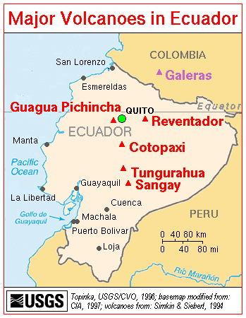 Why are Revantador, Guagua Pichincha, and Tungurahua all erupting now? Let's first consider the recent eruptive history of these volcanoes.
Reventador is a frequently erupting volcano. It sits almost exactly on the equator, and should therefore be a most sensitive indicator of the beginning of pole shift, as Earth's mantle and crust starts to move ever so slightly over the equatorial bulge.
Since the beginning of the 1958-1998 period, during which time reading 3976-15 also said that the Earth changes would begin to be apparent, Reventador has erupted five times (1958,1960,1972, 1973, and 1976). It began erupting strongly again on November 3, 2002.
Guagua Pichincha, after having been quiescent for 100 years, erupted weakly in 1981, 1985, 1990, and 1993. Magmatic eruptions occurred again in October 1999. Intermittent eruptions of varying scale since then have blanketed Quito and surrounding towns with ash. Explosions occurred at Guagua Pichincha on November 3. Ash plumes could not be distinguished from those of Reventador, which was also erupting that week.
Tungurahua began erupting in October of 1999. It had last erupted in 1944.
How Can Polar Upheavals Cause Torrid-Area Volcanic Eruptions?
Earth's torrid areas lie roughly between the Tropics of Cancer and Capricorn, or approximately latitudes 23.5°N and 23.5°S of the equator, respectively. Once again, Halaliel's message, as channeled through
Cayce in reading 3976-15 says:
There will be the upheavals in the arctic and antarctic that will make for the eruption of volcanoes in the torrid areas, and there will be the shifting then of the poles...
Stated clearly here is the proposition that eruptions of volcanoes in the torrid areas can be induced by crustal upheavals in the arctic and antarctic. This seems to imply that upheavals in the polar regions must be of sufficient magnitude to reflect deeper unbalancing of the rotating Earth. Sufficient unbalancing will cause the poles to begin to try to shift. Such activity will cause volcanoes located upon, or to either side of, the equatorial bulge in the torrid areas to erupt in response to the incipient pole shift. The closer an equatorial volcano is to the shift meridian (longitudes along which the poles will appear to move) the greater its eruptive response will be. (One can read about the shift meridian in “A Small Pole Shift Can Produce Most, If Not All, Of The Earth Changes Predicted In Cayce's Readings”).
Any attempt of the overlying mantle and crust to move over or away from the equatorial bulge will cause sufficient disturbance to cause magma to rise into many of the torrid-area volcanoes. Volcanoes closest to the eventual shift meridian could be expected to be the most eruptive. We believe that the shift meridian will be close to the 60º W longitude; see our article entitled Calibrating The Hutton Commentaries' Model For a 1° Pole Shift to 89.0°N. This is important because Ecuador's volcanoes are within 18º of the 60º W longitude.
The idea here is that, as a region of the crust and mantle straddling the incipient shift meridian tries to move toward the equator, it must cover a somewhat larger area (or, in three-dimensions, fill a greater volume). But there is insufficient material available to do so. On the other hand, any torrid-area mass trying to move away from the equator is subjected to contraction, as there is an excess of material available.
In regions of existing torrid-area volcanism, such disturbances of the crust and mantle related to pole shift would be sufficient to facilitate magma flows. Such magma flows would very often lead to eruptions through paths of least resistance in the crust. These would be paths through incipient fractures and existing volcanoes. Old fractures could also be reactivated, allowing magma to move through them.
J. Campbell did some provocative work on shift of the mantle and crust over the equatorial bulge for C. Hapgood's book entitled, “The Path of the Pole” (1970, Chilton Book Co., New York). For example, consider Figure 8 below, adapted from Fig. 34 in Hapgood's book. The figure shows diagrammatically the pattern of faulting and folding during displacement of the crust and mantle. Only one meridional fault (the shift meridian) is shown, which is moving toward the equator in the northern hemisphere. The dotted lines indicate other faults opening from the bottom of the crust as the arc of the surface diminishes. Across the equator, where the crust is moving toward the pole, and compression is resulting, the continuation of the major expansion fault is shown as a pressure ridge. Dashed and solid vertical lines designate other crustal fractures that may be expected to parallel the major meridional fracture.
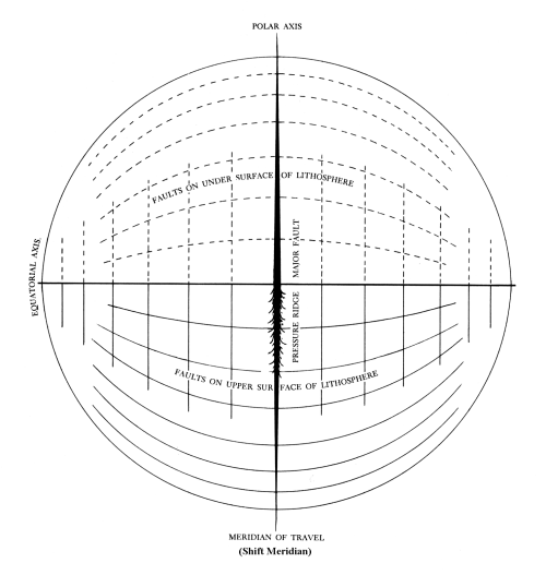 Figure 8. Fractures resulting from movement of the mantle and crust over the equatorial bulge.
Now we have just been talking about the incipient motion of the mantle and crust over the equatorial bulge. Magma can follow paths through fractures under stress; fractures that are trying to begin to open fully from the bottom of the lithosphere in the quadrant moving toward the equator, and through fractures trying to open fully through the top of the lithosphere. Pre-existing volcanoes that are already magma conduits will tend to erupt first.
For our hypothesized global shift meridian of 60.0°W and 120°E, the most eruptive volcanoes will be those in a broad torrid-area region from Indonesia and the Andaman Islands, eastward to the Philippines, New Guinea, New Britain, and the Bismark Archipelago. Note that the 120°E shift meridian is within only 15° of the super-eruptive volcano of Krakatau and within only 2° of Tambora.
In the Western Hemisphere, the most sensitive and eruptive volcanoes will be those extending from southern Mexico, central America, and the Caribbean Leeward Islands, to the Galapagos Islands, Columbia, Ecuador, Peru, Bolivia, and northernmost Chile and Argentina in South America. The subset of volcanoes that will erupt most vigorously will tend to be those closest to the equator in the torrid areas, as well as those nearest to the shift meridian. Thus, the volcanoes of Indonesia and Ecuador (includes the Galapagos Islands) are the centers of the most dangerous volcano regions in their respective hemispheres.
Remember here that there are two volcanoes capable of super-eruptions that are now in early eruptive phases on the opposite side of the Earth. They are Pago (5.6°S, 150.5°E) and Rabaul (4.3°S and 152.2°E). Both are on the island of New Britain.
The Alaskan earthquake's connection to Ecuador's volcanic eruptions
We have always used the 63°N latitude as the southern boundary of the “arctic” region for the purpose of checking for “upheavals in the arctic and antarctic” (reading 3976-15). Note that the epicenter of the Alaskan earthquake of November 3, 2002 was slightly north of this latitude, at 63.47°N.
At M 7.9, this huge quake - with its accompanying robust aftershock series and 65-mile-long rupture zone - certainly qualifies as an upheaval in the arctic. Is it just a coincidence that Reventador erupted three or four times on November 3 and 4? Do we not have here the near-perfect sequence of an upheaval in the arctic coinciding with the eruption of a torrid area volcano? And along with the eruption of Guagua Pichincha on November 3 we seem to have a perfect match. That is, an upheaval in the arctic and the eruption of torrid area volcanoes (plural).
The match is not completely perfect, however, if one looks at the timing of the Alaskan quake relative to the eruption of Reventador. The huge Alaskan quake occurred at 22:12:41 UTC (Universal Time, Coordinated: 22 hr, 12 min., 41 sec), on November 3, 2002. Within 20 minutes, the quake's seismic waves reached the most distant points on the planet from the focus of the quake beneath Earth's surface.
The initial large eruption at Reventador - the first in 26 years - occurred close to 14 hrs UTC. This was about 8 hours before the big quake occurred in Alaska. Note, however, that a strong M 6.7 foreshock of the M 7.9 quake occurred 11 days earlier, on October 23. This was followed by a number of additional foreshocks (in the M 3.0-3.9 and 4.0-4.6-ranges) that occurred up until the mainshock of November 3.
Guagua Pichincha's eruption occurred close to 01:45:00 UTC, on November 4, about three and one half hours after the massive Alaskan earthquake. This is more in keeping with an impulse-response type of model that derives from a straightforward reading of 3976-15; that is, a model in which an upheaval in the arctic or antarctic will cause an almost immediate eruption of one or more volcanoes in the torrid areas.
But consider just below the operation of a less tightly time-constrained impulse-response model for the general eruptions of Ecuador's torrid-area volcanoes, due to crustal or volcanic upheavals in the arctic and antarctic.
Tungurahua exhibited various eruptive activities during the October 30 - November 5, 2002 reporting period. This volcano, however, had begun its eruptive activity in October 1999 (its first since 1925). Guagua Pichincha also began its present eruptive cycle in October of 1999. These volcanoes' eruptions may have been initiated by the more than 200 light-to-moderate earthquakes that were measured between January and August of 1999, along the submerged Gakkel Ridge in the high arctic (centered roughly at 85.7ºN, 81.4ºE). (The submarine volcanism [another kind of “upheavals”] that accompanied these quakes has now been well documented).
Then again, perhaps it was the great (M 8.2) Balleny Sea earthquake off Antarctica that caused Guagua Pichincha and Tungurahua to begin to erupt in concert. This quake took place in March 1998, and was the largest ever detected within an oceanic crustal plate. Its location and great strength were completely unexpected by the world's seismologists.
Article Summary
The message of the Alaskan quake and Ecuador's newly erupting volcanoes seems clear. Three of Ecuador's volcanoes are erupting simultaneously. Two of these began erupting about the same time as the Alaskan quake. To those of us who follow the Cayce readings these events have to be taken as a sign that the poles may be about to shift.
Earth changes accompanying the pole shift will be catastrophic. The initial days of the pole shift seem described in parts of 3976-15.
As to the material changes that are to be as an omen, as a sign that this [return of John the Beloved] is shortly to come to pass - as has been given of old, the sun will be darkened and the Earth shall be broken up in diverse places…
The Earth will be broken up in the western portion of America. The greater portion of Japan must go into the sea. The upper portion of Europe will be changed as in the twinkling of an eye. Land will appear off the east coast of America.
These historically unprecedented Earth changes might occur over several hundreds of years. This is so because geological evidence of tectonic, volcanologic, and seismic activity during the period from about 19,000 to 8,000 years ago shows that such pronounced Earth-change activity occurred many times, in several-hundred-year-long stretches. And that past activity was a follow on, presumably, to the pole shift that began [if the Cayce readings are correct and if I have reasoned correctly from them] around 19,400 years ago. We thus could expect the same sort of duration of continuing planetary effects to coincide with, and follow, the predicted pole shift.
AFTERWORD
A Possibly Genuine Message From Archangel Halaliel On
The Timing Of His Earlier-Predicted “Shifting Of The Poles”
Is it possible for one to obtain an update of Cayce reading 3976-15, in which Cayce channeled archangel Halaliel? (That 1934 reading is the considered to be the best of all of the Cayce readings on pole shift and Earth changes. See “The Sources And Veracity Of Edgar Cayce's Readings - Part 2”). - “Impossible,” you say. “Blasphemous!” says another. “Why not try,” says a third.
Well, we did try, on February 12, 2003. “We,” in this case, consists of a Hutton Commentaries subscriber living in Virginia Beach, Virginia, and Jon Fox, a rather well known psychic living in Nevada City, California. Jon Fox channels an Ascended Master called Hilarion. One can read about Hilarion and Jon Fox on Fox's web site at http://www.hilarion.com.
In the reading that follows, the requestor called Fox on the telephone. Mr. Fox then responded to questions while using a head set. This was a pre-arranged call. Mr. Fox had no idea as to what the questions were going to be. The reading itself was taped by the requestor in Virginia and simultaneously in Fox's office in California. Two days later, I received a duplicate tape of the portion pertaining to Fox's channeling of Halaliel.
Mr. Fox speaks quite rapidly when channeling. This fact, together with the knowledge that the requestor's questions were unknown to Fox before connecting with him by phone, assures me that no advance preparation of “an Halaliel message” could have been done by Fox.
To obtain a useful answer, it is extremely important to frame one's question properly. In the present case, the question was,
Requestor: One of Edgar Cayce's sources was a being identifying himself as archangel Halaliel, spelled H-A-L-A-L-I-E-L. Could you possibly tell me a little bit more about this being, Halaliel, and, if possible, allow him to speak through Jon on the present outlook for Earth changes, particularly on a pole shift, with emphasis on possible dates for same?
Here, after a brief pause, is the answer from Hilarion, and then, slightly later, Halaliel speaks:
Hilarion: This is a powerful, and important guide being who has provided much information and assistance from a mega-level for many beings, many projects, many activities. He's engaged in one now, which will be completed in another few seconds, and then he would be available. This energy has been of much utility to inspire various forms of channeling and assistance for planet Earth, while at the same time there is another ongoing project which he can describe to you. A moment please…
Halaliel: Yes …yes...I am this Halaliel as you understand, and the energies that I have worked with for millennia relate as much to the Earth and her consciousness as to people who inhabit her surface. These beings have much understanding of their own affairs but do not understand the underlying energies associated with Earth's own evolution, the necessity for a pole shift in order to come to new context with regard to deeper understanding of higher consciousness issues is essential. This is as if a paradigm shift for humans.
The understanding of this is to some extent being moderated by cetaceans and their ability to work out some of the emotional energies involved, especially those associated with the dolphin-human interface.
The opportunity to allow these energies, as is being shifted by various sonic experiments in the ocean, is interfering to some extent with these experiments. It may be necessary, in order to allow this understanding of emotions, to incorporate pole shift at an earlier date than was prescribed. It seemed that the paradigm shift as it was originally intended, to focalize somewhere in the area of 2012 A.D., would be an important opportunity for Earth and humans to evolve simultaneously, but this energy may need to be brought sooner into consciousness for many, perhaps even as soon as '05, because the understanding of this energy is being significantly reduced by the necessities for the sonic experiments in the water.
The opportunity to shift this comes by all individuals as they come to deeper understanding of their emotional nature, of how that nature is inherently at an unconscious level, causing the shift that they experience in their world. All this now focalizing on terrorism and related issues is upsetting to Earth. She does not understand why people must resort to these old ways. These are ways that have been on your planet for so long, ways that it seemed as if during the last decade or two were able to be released, ways in which people could find a deeper understanding, if not love, at least to find a way in which they could appreciate, understand, expect the best and appreciate all aspects of each other.
Instead it is as though they had somehow invited or expected to work. This is of course generated from all kinds of energies that are held within the consciousness of those specific leaders. But these energies are generating a powerful emotional shift within people. They do not understand. It is as if these waves of fear, of energy moving through them, are causing all kinds of difficulties. Witness the increase, particularly amongst those of spiritual orientation, of their activities of smoking cigarettes, or drug use, including prescription drugs such as Prozac, and the ways in which this is affecting all kinds of reduction of consciousness on the planet.
But moving away from the specifics to the overall task here. It is important to emphasize that if the pole shift occurs there are opportunities for learning, very powerfully lodged deep within consciousness of all people. To understand this, and their connection to Earth is not an easy matter because those energies will often relate to a deeper understanding of their own emotional nature, of their own ways of blocking, and reducing the ways in which energies have been valuable and helpful for themselves and others.
Thus the other movement moving through your planet. Need for self introspection, a deeper way to understand and welcome all aspects of the internal but shadow self, as well as the life self. If these forces are not sufficient or adequate in allowing people a deeper understanding of how their emotional connected nature is harming Earth, is causing a reduction of the higher awakening spiritual energies, some other activation must be emplaced. The activation is not going to be easy, of course.
The opportunities for pole shift, dramatic Earth change, and other matters that have seemed at times necessary in Earth's past, have to a large extent been pushed forward over and over. There are many excellent reasons for this. And those reasons, relating as much to the consciousness of the higher evolved beings, those in non-physical as well as physical, as those energies can eventually come into form. It would seem far better, for all of those at all vibrational levels, to activate and work together consciously in a place of highest awareness, thus allowing Earth's population to rise to fifty billion or so, so that all souls could interact at the same level, in the same aspect of physicality. Yet, this will require, at a deep level, Earth's cooperation, her physicality, an important part of this process, and right now this would destroy her.
Thus, all of the energies are now in a state of flux in order to determine the new paradigm by which all beings, at all vibrational levels, not just the physical, will live. As these paradigms force themselves out, the possibilities for the manifestation of pole shift or other powerful geophysical changes for Earth then become clear. It is not clear at this time as to which way we will go. At the current aspect, it would seem as if maximum focalization around 2005, or some dramatic change, would be necessary.
Yet, there are many actions to happen between now and then, many ways in which people can come to deeper understanding or awareness as to what is going to happen and what they are creating for themselves by their own unconscious interactions.
Hilarion: Yes... Hilarion here again. We thank you, Halaliel, for your assistance, as vested with the physical body of Jon to allow this transmission.
It is important to recognize that, as these energies are made available, there is an underlying hope, a sense that, amongst all of the connected angels and other beings, the changes that Earth needs for her own shift can now be more clearly created by the consciousness of humans. That was the larger plan, you see.
And these energies are becoming very much, more and more into the main stream, through the actions of ecology, and where ecology, politics, and economics come together. But, this is simply not happening with enough speed to keep up with the more negative, emotionally based energies.
It isn't to say that emotions are bad, they certainly are not, but their lessons are simply not being understood. After all, this war against terrorism is only creating more terror, more fear, on your planet. And this is what Halaliel is referring to as to underlying difficulties relating to the unconscious.
Is this of any help to you?
-
Lander, J. F., and Others, 1993, National Geophysical Data Center, Boulder, CO 80303, 242 pp.
-
Calderas are caused by eruptions that are among the largest of volcanic explosions, ejecting tens to hundreds of cubic kilometers of magma. After such large volumes are ejected from volcanoes, the ground collapses into empty spaces to form huge depressions, or "calderas."
-
Science Daily Magazine, 07/25/98, on the Web.
| Picture Credits: | The painting of Vesuvius is from a private collection. It was published in: van Rose, S., and I. Mercer, 1991, Volcanoes, ISBN 0-674-94307-4. |
| The photo of Mt. Pelee is also from van Rose and Mercer. | |
| The 1984 photo of Kilauea in eruption is from Tilling, R.I., and Others, 1993, Eruptions of Hawaiian Volcanoes, US GPO 358-906. | |
| The 1985 photo of Kilauea is adapted from USGS Hawaiian Volcano Observatory website |