
Archived Articles
Calibrating The Hutton Commentaries'
Pole-shift Model With Reading Predictions
For Japan, Egypt, And Yucatan
Pole-shift Model With Reading Predictions
For Japan, Egypt, And Yucatan
Summary
The small pole shift to 89.0°N, 79.2°W that was investigated in our previous article does not submerge enough of Japan to meet the requirements of reading 3976-15. Slightly less than one-half of Japan, not "the greater portion," goes into the sea. This can be remedied if we run the pole-shift model for a greater degree of shift, to say 88.5°N. But then, the Sphinx goes beneath the sea, making recovery of the Hall of Records materials nearly impossible. If however, we use a shift meridian of 58.0°W, while retaining our original 1° southward motion of the pole to 89.0°N, there are no problems with post-shift records-access in either Egypt or Yucatan. And the greater portion of Japan goes into the sea.
Earth-change consequences for our new post-shift, north-pole coordinates compare quite favorably with the requirements of the readings for Japan, Egypt, and Yucatan. We recommend, therefore, that future research on the Cayce-readings consequences of pole-shift be based on movement of Earth's north pole of rotation to 89.0°N, 58.0°W.
Background
At the end of The Hutton Commentaries' (THC's) initial article on a small pole shift, we indicated that we planned to calibrate the modeled shift results against Earth-change predictions from the readings. We said also that we were looking for a shift meridian that would satisfy, simultaneously, three predictions from the readings for separate parts of the world. These predictions required that:
- the post-pole-shift results for Japan match Archangel Halaliel's prediction that, "the greater portion of Japan must go into the sea" (3976-15),
- the shallow sea floor off Yucatan be drained so that "the temple by Iltar will rise again" (5750-1), allowing a copy of the records of Atlantis to be found, and
- the Giza plateau in Egypt not be flooded, so that another copy of the records of Atlantis could be found near the Sphinx.
We have found that the above minimum conditions are not all met by a one-degree pole shift to 89.0°N, 79.2°W. Upon close inspection Japan loses up to about half of its land to the sea, not its "greater portion," when the pole moves one degree southward down the 79.2°W shift meridian. The Sphinx is covered by 344 ft (105 m) of Mediterranean seawater, making it impossible to search for a copy of the hall of records containing the history of the Atlantean civilization. Only the prediction that "there will be seen new lands off the Caribbean Sea, and DRY land will appear" (3976-15) is found to be satisfied in the modeling effort. This last result permits searching for Iltar's temple containing another copy of the Atlantean records because the shallow bank offshore of present-day Yucatan is drained following pole-shift.
We made additional computer runs to find the optimal shift meridian to satisfy the above three governing predictions, finally settling on 58.0°W. Choice of this meridian puts the Giza plateau within 1° of the 32°E neutral meridian. This neutral meridian lies 90° from the 58.0°W shift meridian. A neutral meridian is one of two meridians that incur no change in sea level due to a pole shift. Find below a synopsis of the new modeling results, together with some comments on their significance.
Halaliel's Prediction For Japan, And Notes on Regional Results
Japan. For comparison with our earlier results, Figure 1 is a blow-up of the Japanese archipelago from The Hutton Commentaries' (THC's) computer-generated world map for a 1° pole shift to 89.0°N, 79.2°W. This blow-up shows that roughly only half of Japan is submerged. Because this result does not meet Halaliel's "greater portion" stipulation, we decided to investigate the effects on Japan of a pole shift down the 58.0°W meridian.1
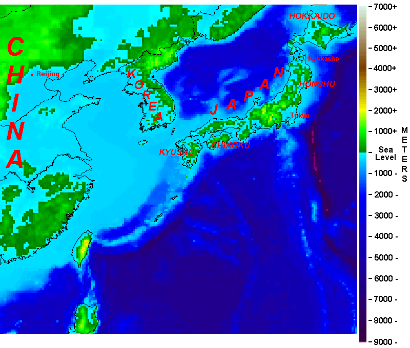
Fig. 1. Blowup of Japan and Surrounding Region as Depicted on THC's World Map for a One-Degree Pole Shift to 89.0°N and 79.2°W. Each colored square on the maps in this article is 11.5 statute miles on a side, and covers 133 square miles. The elevation shown by a color-shade is the same everywhere within the square. Each different shade denotes a change of elevation of 62.5m, or 205 ft up or down relative to mean sea level.
Now, let us change the pole-shift meridian to 58.0°W and rerun the model. This change in the shift meridian shows clearly (Fig. 2) that "the greater portion of Japan" has indeed gone "into the sea," following Halaliel's prediction in 3976-15.
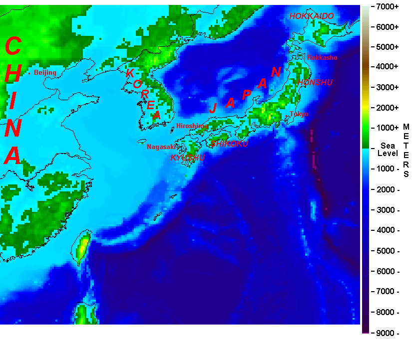 Fig. 2. Blowup of Japan and Surroundings Immediately After a 1.0° Pole Shift to 89.0°N, 58.0° W. Compare to Fig. 1.
 With the possible exception of the area enclosing higher elevations west of Tokyo, more than one-half of each of the islands of Hokkaido, Honshu, and Kyushu are flooded as a result of the new sea-level geoid that is in effect immediately after pole shift. For a full explanation of the effects of a pole shift on the sea-level geoid, see our article, "How a Small Pole Shift Can Produce Most, If Not All, of the Earth Changes Predicted in Cayce's Readings".Hokkaido is especially hard hit.Tokyo lies under 705 ft of ocean water. Rokkasho, on the northeast coast of Honshu, and the site of the plutonium reprocessing plant discussed on p. 221 of Coming Earth Changes, lies 850ft beneath the sea.
We believe that we are now on the track of a pole-shift direction that reproduces well the Earth changes described in Halaliel's vision (3976-15). Thus, the rest of our interpretations will be based upon a sudden, 1.0° shift of the north pole of Earth's rotation axis to 89.0 °N and 58.0°W.
The Koreas. About 80 percent of South Korea and perhaps one-half of North Korea is submerged, as shown in Figure 2.
China. In northeastern China the populated lowlands are submerged from Qiqihar and Harbin on the north, southward to Shenyang and Anshan, Beijing (formerly Peking) and Tianjin, Jinain and Quindao, and on to Nanjing and Shanghai and then to the west to the Wuhan-Nanyang area. (Not all population centers named are located with the boundaries of Fig. 2). Beijing is under 1,073 ft of water.
The submerged cities or regions noted above remind us of Ms. 1152's reading that says:
[And] what is the coastline now of many a land will be the bed of the ocean. Even many of the battle fields of the present will be ocean, will be the seas, the bays, and the lands over which the NEW order will carry on their trade as one with another.
1152-11; August 13, 1941
Recall that beginning in 1937, after invading Shanghai, China, the Japanese military trained its sights on Nanking (now called Nanjing). There, in December 1937, in one incident alone, the Japanese gunned down 57,000 civilians and former soldiers. The Japanese army burned down much of the Chinese imperial city and slaughtered several hundred thousand residents. This occurred during the Sino-Japanese war that preceded World War II.
Time-wise, "the battlefields of the present [1941]" in reading 1152-11 seem to cover the Sino-Japanese war, all of WW II, and possibly the Korean war as well. Also, the atom-bomb-devastated cities of Hiroshima and Nagasaki are under water.
Egypt And The Eastern Mediterranean
Figure 3 shows Egypt and the eastern Mediterranean immediately after the 1° pole shift on the 58.0°W meridian. Note that the pink dot in Figure 3 is on a green square that represents the location and elevation of the Giza plateau. The elevation of the Sphinx is a bit lower. Here are three readings that explain the location and nature of the records of Atlantis in Egypt, and which describe the inherent crustal stability that was - and is--to be expected for this part of the world (northern Egypt and the Giza plateau).
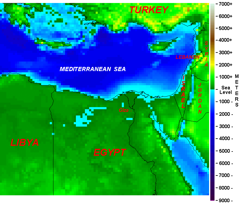 Fig. 3. Land-Sea Boundaries in the Eastern Mediterranean Immediately After a 1.0° Pole Shift to 89.0°N, 58.0°W.
 With the storehouse, or record house (where the records are still to be uncovered), there is a chamber or passage from the right forepaw [of the Sphinx] to this entrance of the record chamber, or record tomb. This may not be entered without an understanding, for those that were left as guards may not be passed until after a period of their regeneration in the Mount, or the fifth root race begins.
5748-6; July 1, 1932
Q Give in detail what the sealed room contains.
A A record of Atlantis from the beginnings of those periods when the Spirit took form or began the encasements in that land and the developments of the peoples throughout their sojourn, with the record of the first destruction and the changes that took place in the land, with the record of the sojournings of the peoples to the varied activities in other lands, and a record of the meetings of all the nations or lands for the activities in the destructions that became necessary with the final destruction of Atlantis and the buildings of the pyramid of initiation, with who, what, where, would come the opening of the records that are as copies from the sunken Atlantis, for with the change it must rise (the temple) [the temple on Atlantis] again.
3976-16; October 29, 1933
Why Egypt? This had been determined by that leader or teacher (not physical leader, but spiritual interpreter or guide) as the center of the universal activities of nature, as well as the spiritual forces, and where there might be the least disturbance by the convulsive movements which came about in the Earth through the destruction of Lemuria, Atlantis, and - in later periods - the flood...
When the lines about the Earth are considered from the mathematical precisions, it will be found that the center is nigh unto where the Great Pyramid, which was begun then, is still located.
281-42; November 1, 1939
Figure 3 reveals hardly any flooding throughout the Nile delta and the coastal lowlands of Egypt. Thus, the pyramids, the Sphinx, and the Hall of Records are all preserved following the pole shift. (Note, however, that coastal lowlands of Israel, Lebanon, and Syria are flooded, as is the valley north of the Dead Sea).
Now consider these words from reading 3976-16 above, which state that the temple of records on Atlantis "with the change... must rise again." This "rising" seems destined to occur by tectonic uplift, rather than by draining of the deep-Atlantic sea floor near the Azores following a pole shift. Such a conclusion is supported by the following reading, which indicates that, in 1939, the temple in Atlantis was already rising.
It would be well if this entity were to seek either of the three phases of the ways and means in which those records of the activities of individuals were preserved - the one in the Atlantean land, that sank, which will rise and is rising again; another in the place of the records that leadeth from the Sphinx to the hall of records, in the Egyptian land; and another in the Aryan or Yucatan land, where the temple there is overshadowing same.
2012-1; September 25, 1939
Yucatan, Gulf of Mexico, Caribbean Sea, and the Bahamas
Figure 4 focuses on Yucatan, Cuba, and the Bahamas for a 1.0° pole shift to 89.0°N, 58.0°W. In contrast to the flooding experienced by lowlands in Figures 2, here, in one of Earth's two negative quadrants after pole shift, we see the results of draining of formerly shallow shelf areas. This draining occurs in response to pole shift and the associated sudden imposition of a new sea-level geoid.
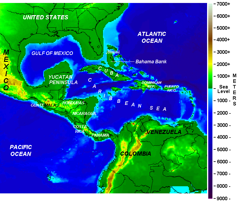 Fig. 4. Land and Sea Changes in the Vicinity of Yucatan, Cuba, and the Bahamas, Immediately After a 1.0° Pole Shift to 89.0°N, 58.0°W.
 Yucatan gains a huge area of dry land from the former, shallow continental shelf to its north and west. Cuba also gains land, primarily along its southern shore. The Bahamas, and particularly the Great Bahama Bank and shallow sea floor around Bimini emerge from the sea. Cuba and the Bahama Banks almost join at one point. Off the southeastern coast of Honduras, and all of the east coast of Nicaragua, considerable new land rises from the sea. A long strip of land is also added to the west coasts of these nations, as well as to Guatemala and southern Mexico.
As mentioned in our basic article on a small pole shift, these land and sea changes comport well with the following readings:
Q Is this [Bimini area] the continent known as Alta of Poseidia?
A A temple of the Poseidians was in a portion of this land [somewhere near Bimini on the Great Bahama Bank, in all probability].
996-12; March 2, 1927
And, as may be known, when the changes begin, these portions [of, as a minimum, the Great Bahama Bank near to and including Bimini] will rise among the first.
587-4; July 1, 1935
Land will appear off the east coast of America... There will be new lands seen off the Caribbean Sea, and DRY land will appear.
3976-15; January 19, 1934
Yet, as time draws nigh when changes are to come about, there may be the opening of those three places where the records are one, to those that are the initiates in the knowledge of the One God:
The temple by Iltar will then rise again. [Emphasis added]. Also, there will be the opening of the temple or hall of records in Egypt, and those records that were put into the heart of the Atlantean land may also be found there -- that have been kept, for those that are of that group.
The RECORDS are ONE.
5750-1; November 12, 1933
Reading 5750-1 also states that Iltar left Atlantis prior to its destruction and brought to Yucatan the records of the history of Atlantis. He and his followers erected the first temples there. The temple holding the records "was destroyed at the time there was the last destruction in Atlantis." This occurred "at the period of change when much of the contour of the land in Central America and Mexico was changed to that similar in outline to that which may be seen in the present."
A plausible scenario can be offered to link Iltar's destroyed temple with former submergence, and future draining, of the Yucatan shelf. Assume that the temple had been constructed on land that is now submerged, appearing on present day maps as the extensive shallow shelf off the northern and western shores of Yucatan. As the last part of Atlantis plunged into the depths in the Azores area, the disturbance was felt all the way to Central America. Strong earth movements and associated earthquakes related to changes in the "contours of the land" destroyed the temple that holds a copy of the historical records of Atlantis.
If the temple was not submerged during the upheaval about 12,000 years ago, it might well have become so in response to rising worldwide sea level following the peak of the last glaciation. This global sea-level rise amounted to about 170 ft (51.8 m), as based on F. Shepard's (1963) sea-level rise curve obtained from C-14 dates in relatively stable areas. Drainage of the ocean water now covering the Yucatan shelf following pole shift would expose the bottom, causing the bottom to "rise" some 410 ft relative to the new, post-shift sea level.
Such a scenario fits well with the statement, "As the time draws nigh when [pole-shift and Earth] changes are to come about,...the temple by Iltar will then rise again." Thus, the temple's rubble could rise above the sea and be on the "dry land" that would appear. And "the RECORDS" could then be found.
Figure 5 shows the location of three important Archaic-period archaeological sites in Yucatan.
 Figure 5. Archaic Sites and Sites of Early Hunters (see Hutton and Eagle, 2004, Earth's Catastrophic Past and Future, p. 203).
 Loltun Cave is an enormous cavern complex that was used by the Maya for thousands of years. It contains bones from extinct animals, making the cave remains around 13,000 years old. The Belize Archaic Archaeological Project directed by Richard MacNeish found four different sites (cf. Fig 5) "perhaps to be dated on typological grounds to 9000-7500 BC" (Coe, p. 43). The Belize and Loltun sites, while putting early hunters in Yucatan 12,000 years before the present, do not, apparently, contain any artifacts that might represent an Atlantean civilization. At the same time, however, it seems highly probable that additional 12,000-year-old sites of human habitation can be expected to be found on the submerged shelf offshore of the coasts of Yucatan.2
Timing of The Pole Shift and Related Earth Changes
Exactly when will the above-described pole shift and Earth changes take place?
As to times and places and seasons - as indeed has been indicated in the greater relationships established by prophets and sages of old -- especially as given by Him: "As to the day and hour, who knoweth? No one, save the Creative Forces."
416-7
- Note that in 1962, B. G. Bromford (Geodesy, Oxford/Clarendon Press), stated that there was evidence of secular movement of the north pole, southward along the 60°W longitude. While more recent data suggest that the direction for the last century has been along the 79.2°W longitude, it seems more likely that a band of longitudes may contain equally reasonable possibilities, as long as the slow drift of the north pole is southward toward eastern Canada. [back]
- Scott Milburn kindly directed our attention to Coe's work. [back]