
Archived Articles
More ''Rocks Of Atlantis'' Are
Confirmed Widely Over The
North Atlantic Ocean Floor
Confirmed Widely Over The
North Atlantic Ocean Floor
KEY FEATURES OF THIS ARTICLE
The ancient ages of rocks, fossils, and sediments found at numerous places on the North Atlantic Ocean floor indicate that the hypothesis of sea-floor spreading is inaccurate and should in large measure be scrapped. Previous explanations as to the origin of ancient continental-rock fragments on the sea floor are almost laughably incorrect. Vertical, primarily downward, movements of the oceanic crust have been far more important to the geologic history of the Atlantic basin than have horizontal movements of the crust, as championed by believers in plate-tectonics. The Edgar Cayce psychic readings on the geologic history of the destruction of Atlantis fit far more easily into tectonic conjectures by present-day geologists and researchers unencumbered by the hypothesis of sea-floor spreading. A proposed classification of ancient and continental rocks on and beneath the Atlantic ocean floor allows for the insertion of the specific rocks of Atlantis discovered by Hutton and Eagle in their drilling and core-sampling of rocks at Bimini in 2007. That work followed clues found in the Cayce readings. (Read the details of the proposed crustal uplifting activity at the end of this article.)
INTRODUCTION
John Ziman is a physicist and science analyst. In 1978, he wrote, “Institutionalized collegiate science is always vulnerable to the charge that it is no more than an 'Establishment' that defends only its own orthodoxy. The consensus towards which science strives applies, in practice, only to the members of a scientific community already heavily indoctrinated in the current paradigm. Despite all its high ideals and good intentions, such a community must inevitably resist radically new ideas that upset its hard-won position and throw into doubt all the earnest labours of its members”. Present-day Earth science, to the extent that it is dominated by the hypothesis of plate tectonics, readily conforms to Ziman's description. In peer reviewed journals, as well as on grant-giving boards, criticism of established paradigmatic 'rules' and views are commonly suppressed – thus blockading free exchange of opinion, the cornerstone of true science. Such a fate has befallen serious investigation of alternatives to the hypotheses of 1) sea-floor spreading and 2) the presence of a former land mass in the north Atlantic Ocean called Atlantis.
In the Hutton Commentaries continuing research and validity-testing of Edgar Cayce's readings on Atlantis, we have had modest success in finding evidence of the rocks of the former continent, as located in the following readings.
...while the destruction of this {Atlantean} continent and the peoples are far beyond any of that as has been kept as an absolute record, that record in the rocks still remains... (emphasis added by Hutton).
The position as the continent Atlantis occupied, is that as between the Gulf of Mexico on the one hand - and the Mediterranean upon the other. Evidences of this lost civilization are to be found in the Pyrenees and Morocco on the one hand, British Honduras, Yucatan and America upon the other. There are some protruding portions within this that must have at one time or another been a portion of this great continent. The British West Indies or the Bahamas, and a portion of same that may be seen in the present - if the geological survey would be made in some of these - especially, or notably, in Bimini and in the Gulf Stream through this vicinity, these may be even yet determined.
(364-3)
(Q) How large was Atlantis during the time of Amilius?
(A) Comparison, that of Europe including Asia in Europe - not Asia, but Asia in Europe - see? This composed, as seen, in or after the first of the destructions, that which would be termed now - with the present position - the southernmost portion of same - islands as created by those of the first (as man would call) volcanic or eruptive forces brought into play in the destruction of same.(364-6)
The following map is our interpretation of these readings, from chapter 26 of our book, Earth's Catastrophic Past and Future.
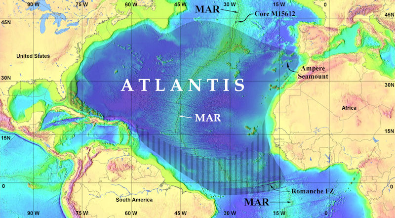 Fig. 1. Approximate outer limits of Atlantis at its greatest extent. Vertical-stripe pattern indicates our best estimate of "protruding portions within this [Atlantis] that must have at one time or another been a portion" of the legendary lost continent.
 MAR = Mid_Atlantic Ridge;
FZ = Fracture zone.
Now comes a new compilation of that record in the rocks that still remains of lost Atlantis, although the authors of that compilation are loath to use that explanation ("Atlantis").
NEW DATA ON ANCIENT CONTINENTAL-TYPE ROCKS
IN THE NORTH ATLANTIC OCEAN BASIN
A stunning and scholarly study was web-published last month in the New Concepts In Global Tectonics (NCGT) Newsletter [no. 53, December 2009]. It is titled "Ancient and Continental Rocks In The Atlantic Ocean," and authored by T. Yano, D. Choi, A. Givrilov, S. Miyagi, and B. Vasiliev. Here's their abstract.
According to the hypothesis of ocean-floor spreading, oceanic crust contains no rocks older than 0.2 Ga* or so of continental origin. The Atlantic oceanic crust, however, includes rocks as old as 1.85 Ga and of continental constituents, such as granitoids, gneisses, schists, granulites, coarse-grained terrigenous clastics, and continental peridotites. This paper describes these rocks from 42 localities and groups them into 4 types. The occurrence of these rocks has prompted ad hoc modifications to the sea-floor spreading hypothesis, e.g. ceased spreading or older sediment patches getting left behind, non-spreading areas, multiple ridge jumping, oscillatory spreading, small roll-like convection cells located beneath both sides of a spreading axis, delamination, etc. All these modifications are contrived and unsupported by firm data.
The widespread occurrence of ancient continental rocks is compatible with the hypothesis of the oceanization of a former continental outer layer in the present oceans. The currently available data suggest that the Atlantic Ocean formed as a result of complex interaction of tectono-thermal, magmatic and rifting processes in the Middle Mesozoic which destroyed and oceanized the ancient continental lithosphere. Since marine geological surveys are still extremely sparse and the ancient continental rocks discovered to date have only been found by accident, future drilling and dredging may prove the systematic presence of ancient continental rocks in the Atlantic. All hypotheses on the origin of the Atlantic should be reexamined in the light of the increasing volume of rock specimens from the ocean floor.
The following map is Figure 1 of the NCGT newsletter posting.
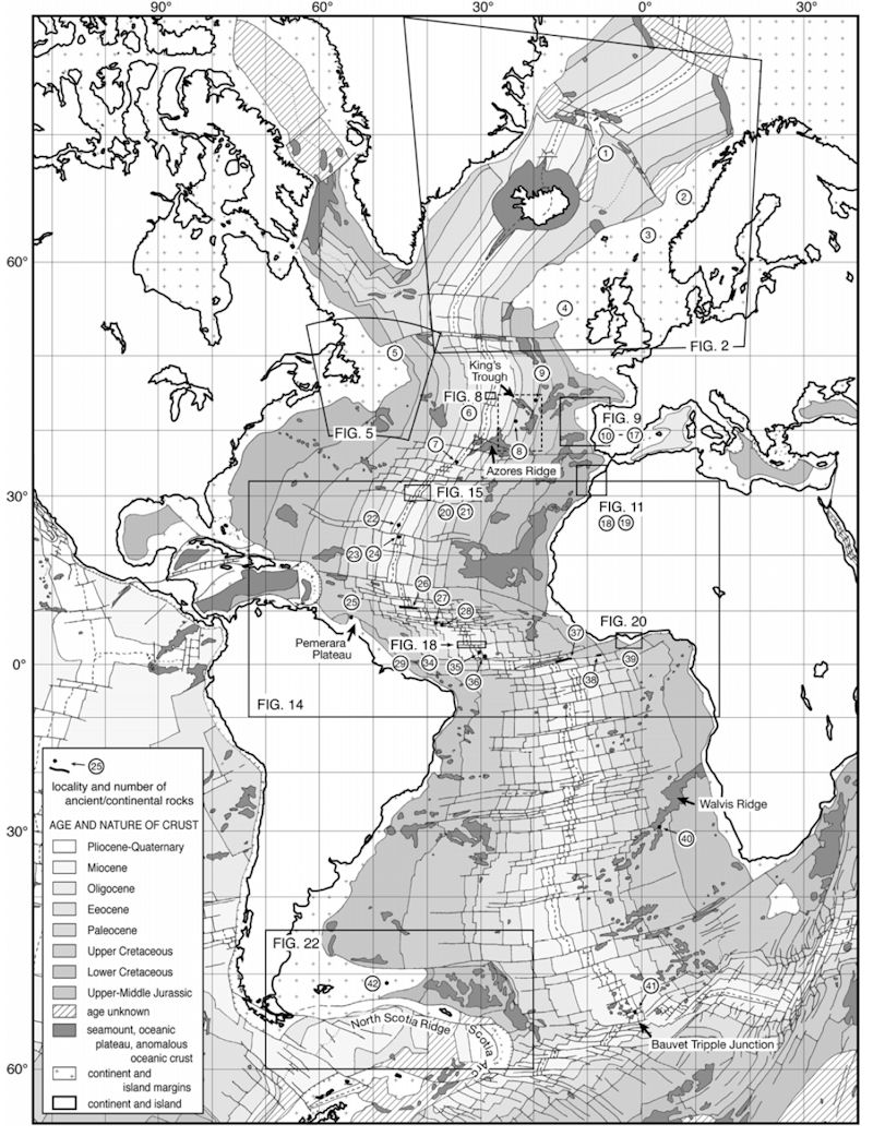 Localities of ancient and continental rocks in the Atlantic. For comparison, the localities are superimposed on the theoretical age distribution of the ocean floor according to plate tectonics. Simplified after Dercourt (2000), Sigmond (2002), etc.
 Note that we will only be addressing points 6 through 39 on the map, to stick within the boundaries of our own map of the boundary limits of Atlantis. All of the reference points from the map of the NCGT article make the point, however, that there is growing evidence of a great region of oceanized crust on the NCGT map. "Oceanization" refers to the conversion of continental crust into oceanic crust. And there is increasing evidence of foundering [or sinking] of the Atlantic ocean floor rocks. To give one a flavor of the types of evidence associated with the various points on the NCGT map, consider the narratives for points 6-9, which are relevant to what THC believes to be the last major portion of Atlantis to sink, Poseidia around 11,900 years before the present. Our reasons for locating Poseidia in this area can be found in our article entitled, Locations Of The Records Of The Atlantean Civilization And Its Firestone - Including Speculations On Where Or How They Will Be Found.] Full citations to referenced articles cited below can be found in the original NCGT paper. (One can subscribe to the NCGT neswsletter here.)
6 Continental rocks in Bald Mountain
Bald Mountain, situated at 45°N latitude, 60 km west of the mid-oceanic ridge (Fig. 1), is a narrow fault block measuring 28 km from north to south, 5.5 km wide, 1.2 km deep at the top, and 1.3 km high from the ocean floor (Fig. 8). This seamount has remarkable characteristics in that, (a) it is oblique to the Mid-Atlantic Ridge missing cover sediment, as its name implies. The underwater camera observation revealed the exposure of massive rocks and the development of cubic joints characteristic of coarse-grained intrusives (Aumento and Loncarevic, 1969). Two dredgings on the western slope and one dredging on the eastern slope of the southern part of the seamount (Fig. 8-b; their basket drag ranges from 500 to 800 m in depth). Out of the 84 rock samples, 64 samples (75%) were continental (sandstone, limestone, gneiss, granite, granodiorite, amphibolite and granulite; Aumento and Loncarevic, 1969).
The other 20 samples were mafic rocks – gabbro, metabasalt and basalt. Among them, coarse gabbro gave a KAr schistosity (Amento and Loncarevic, 1969). Basalts are alkaline (“transitional”), three of their samples produced K-Ar ages of 8 Ma (Aumento et al., 1968). Some basalt samples have conspicuous submarine weathering and a thick manganese crust (Aumento and Loncarevic, 1969). For the origin of granitic rocks from Bald Mountain, F. Aumento (in: Wanless et al. 1968, p. 140-141) suggested two interpretations: dropstones and continental block. However, as Aumento admits, it is difficult for the former to explain the dense distribution of continental rocks, and the latter requires a convincing mechanism to explain how the continental block has stayed at the present site without being carried away by the spreading sea floor. The continental rocks have not been registered in the Canadian Geological Survey's repository samples under the pretext that they may be glacier-origin erratic rocks, citing the lack of manganese crust, abrasion, poorly weathered features, variety of rock species and the presence of striaes at the surface (Aumento and Loncarevic, 1969). The coarse-grained gabbro was labelled dropstone, because of their belief that there are no ancient rocks near the mid-oceanic ridge (Wanless et al., 1968). However, as stated elsewhere, it is obvious that, (a) crystalline basement is exposed in Bald Mountain, (b) most of the dredged samples are continental or ancient rocks, (c) some basalt samples have conspicuous underwater weathering and thick manganese crusts (Aumento and Loncarevic, 1969), and (d) the basket drags are very long. These facts are unfavorable for Aumento and Loncarevic's claim of a glacial dropstone origin. Furthermore, as Aumento pointed out (in Wanless et al., 1968; p. 140-141), it is impossible to sustain the dropstone theory unless a reasonable explanation is given for the intensive dropping of ice-rafted rocks exclusively on Bald Mountain. In addition, the presence of continental crust in the Jan-Mayen Ridge (Fig. 2) as described earlier, and the numerous ancient continental rocks in the equatorial Atlantic axial region refute the claim of Wanless et al. (1968) that there are no ancient rocks in and around mid-oceanic ridges. The observed facts at Bald Mountain support the continental block interpretation, which is one of Aumento's ideas. The volume of the southern part of Bald Mountain is about 80 km3 (Meyerhoff et al., 1992). We expect a new survey of the region to yield a vast amount of highly valuable information on ocean-floor geology. We also call for the publication of detailed information on the dredged ancient continental rocks at Bald Mountain in regard to their localities and characteristics.
7 Ancient and continental-origin basalt near the Azores Islands
The Oceanographer Fracture Zone south of the Azores (35°N) produced a 130 km dextral offset. The Alvin dive made at the northwestern offset in the mid-axial valley (Fig. 1 - 7) collected many rock samples which New Concepts in Global Tectonics Newsletter, no. 53, December, 2009 13 are all tholeiites enriched with incompatible elements, which are classified into three groups based on isotope composition (Shirey et al., 1987). Among them, seven samples in Group A occurred only in a narrow belt (2 km x 15 km). Therefore, the samples are considered to have derived from a single rock unit. Unique isotope signatures (Pb, Nd and Sr) which characterize Group A indicate contamination by Archean or Proterozoic continental mantle materials by 8-12% (Shirey et al., 1987). In the longer axis of the mid-Atlantic (41°N and 31°N), minor elements and the Pb-Sr-Nd isotope of 96 basalt samples also showed outstanding anomalies – indicating contamination by continental materials (Dosso et al., 1999), but with the exception that no Nb-Ta negative anomaly, which is characteristic of the continental mantle, was recognized. Also the source mantle in this segment of the Mid-Atlantic Ridge is very uneven, which may be derived from the mantle mixing that enriched the depleted mantle 250 Ma (Dosso et al., 1999). The Azores Islands (Fig. 1) branch ESEward from the Mid-Atlantic Ridge at about 39°N. The Os and Re isotope compositions of lavas in the Azores Islands suggest the presence of an Archean oceanic mantle fragment under the islands. This mantle fragment is speculated to have been recycling in the mantle since it was delaminated from the oceanic lithosphere in the Archean (Schaefer et al., 2002). To summarize, the upper mantle under the Azores consists of ancient and continental rocks, represented by: (a) continental mantle, (b) uneven mantle formed in the Late Paleozoic, and (c) an Archean mantle fragment. (Emphasis added by Hutton.)
8-9 Paleozoic sedimentary rocks off Azores-Iberia
In the region surrounded by broken lines in Fig. 1, it has long been known that fossiliferous Paleozoic sedimentary rocks are caught in fishing nets from submarine rises (eastern slope of the northern Azores Islands, the northern slope of the Azores-Gibraltar ridge, which stretches from the Azores Islands to the Gibrartar Strait, etc.). In 1883 a French research vessel Talisman dredged quartzites, siliceous limestones and a shale fragment with an unidentified trilobite from Station 133 (Fig. 1 - 8 ; 42°19'N, 23°36'W, depth 3,975 to 4,060 m) and from Station 136 pumice fragments (derived from the volcanic Azores Islands), a large number of quartzites, flints, limestones and a shale fragment with a small trilobite (Furon, 1949; Schneck, 1974).
Many other samples since then are stored in Sedgwick Museum of Cambridge University. They include an Ordovician (Caradocian) trilobite Triarthus aff. T. spinosus and a graptolite Climacograptus typicalis (Meyerhoff, 1981; Meyerhoff et al., 1992). Many globigerinoids are sticking to all the samples recovered by the Talisman (Furon, 1949) and the range of fossil ages is limited (Meyerhoff et al., 1992). Hence it was concluded that the ancient continental rocks were neither ice-rafted nor ship balasts, but had probably been derived from nearby basement highs and buried within silty sediment containing globigerinoids (Furon, 1949; Schneck, 1974; Meyerhoff et al., 1992).
We now add three additional sites that reveal evidence of former Poseidia at which oxidation of basalt {an igneous rock} once exposed to the air has been found. These rock samples were taken at 12,000 ft plus depths within the medial valley of the Mid-Atlantic Ridge (the MAR). This map is from Chapter 26 "Evidence of Ancient Atlantis."
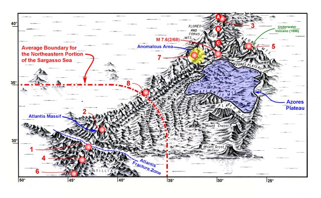 Fig. 6. Physiographic reconstruction of Poseidia (called here Poseidonis). Note the location of the major M7.6 earthquake of 1968. Recall too this reading fragment, "And Poseidia will be among the first portions of Atlantis to rise again. Expect it [to begin clearly to rise?] in sixty-eight and sixty-nine…." [958-3]. A repository for the records of the Atlantean civilization may be found in the shaded area. The Atlantean records repository will be found in a specific temple "where a portion of the temples may yet be discovered" (see reading 440-5). See text for an explanation of dots A-C, sites of deep-water sampling of subaerial material representative of an emergent continent. After p. 362 of N. Zhirov, 1970, as based on a diagram by B. Heezen and M. Tharp.
Direct Evidence of an Emergent Atlantis
Additional information relevant to a possible formerly emergent continent in the Atlantic Ocean was summarized by MacKenzie Keith. (Keith, M., 2001, "Evidence for a plate tectonics debate," Earth-Science Reviews 55:235-336, 318. "... resolved that plate tectonics is the most fantastic house of cards that has ever been erected in science.")
Professor Keith's review provided data on former shallow water or emergent sites sampled by the Deep Sea Drilling Project (DSDP). The sampling sites are currently underwater in the region of the Mid-Atlantic Ridge (MAR). Locations for three of these sites are shown by large dots (labeled A, B and C) on Figure 6. The dots are rather large because, while the sampling coordinates that are listed give degrees north latitude, they do not give degrees west longitude. It is understood, however, that the samples were taken in the vicinity of the MAR's axial valley, clearly visible on Figure 6.
Here's what was found at point A, at a depth of 12,802 ft - highly vesicular basalt, weathered and oxidized basalt, and a major gap in the basal sedimentary section that indicates subaerial erosion. At site B, at a depth of 12,440 ft - basaltic pebbles and weathered and oxidized basalt. And at site C, in 12,313 ft of water - once again, basaltic pebbles and weathered and oxidized basalt. All of the above findings are strong indicators of a formerly emerged MAR. And they suggest that this volcanic terrain has sunk a minimum of 12,300 ft since being exposed to the atmosphere.
Note that Keith's Table 1 lists six additional MAR sampling sites to the south of those plotted on our Figure 6 and on down to the equator. Two of these sampling sites show ridge tops flattened by wave erosion, one site revealed Tertiary-age (2-65 Ma) shallow water sediment, and another site revealed Cretaceous-age (65-150 Ma) shallow water sediment. A final, rather startling finding at a depth greater than 9800 ft consists of canyons and a trellis drainage system, quite probably formed subaerially. Trellis drainage systems consist of parallel main streams with right-angle tributaries, and are typically found on land, in places such as the Appalachians. That MAR location is between 26º and 27ºN, to the south of the area covered in Figure 6. These additional observations indicate once again a formerly emergent area; that is, an area formerly above sea level.
Returning now to the NCGT paper, the authors have classified ancient and continental rocks from the Atlantic Ocean floor into the following four groups and subdivisions (Fig. 24).
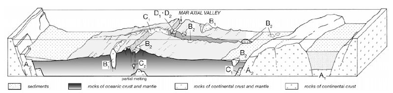 Figure 24. Schematic diagram showing occurrence of ancient and continental rocks in the Atlantic (not to scale, specific exaggeration for ancient and continental rocks). A: continental crust subsided to the depth of the ocean floor or more (A1: base of deep sedimentary basin, A2: ocean margin), B: continental block, rock and mineral in the ocean floor (B1: block, B2: rock mass and mineral), C: continental block and rock with geochemical designation (C1) and volcanics derived from their partial melting (C2), D: ancient sediment (D1) and rock (D2) in comparison with estimated age of ocean plate.
| (1) Type A: | Continental crust-mantle blocks in the continent-ocean boundary area, at depths from 2,500 to 6,000 m (or deeper) below sea level. They are basement blocks in deep sedimentary basins in the continental margin (A1: 2 , 3 , 4 ) and subsided fault blocks in the oceanic margin (A2: 5 , 10 , 11 , 12 , 13 , 14 , 18 , 19 , 25 , 39 , 42 ). | |
| Type A indicates the subsided continental basins deeper than the ocean floor depth or that parts of continent turned to deep-sea basins or abyssal plains. The timing for deepening tends to concentrate in the Cretaceous to Paleogene (5 Orphan Knoll - Late Cretaceous to Paleocene; 10 to 17 offshore Iberia – Albian to Early Campanian; 18 to 19 offshore Morocco – Late Jurassic to mid-Middle Cretaceous; 25 Demerara Plateau – after Late Jurassic; 42 Falkland Plateau – Late Cretaceous to Paleogene), and in the North Atlantic 1 to 4 may be slightly younger than others. | ||
| (2) Type B: | Ancient continental rocks which are distributed from the mid-oceanic ridge to the basins on both sides. They are relatively large crustal units up to hundreds of kilometres long (B1: 1 , 6 , 38 ), and masses, blocks, or mineral grains (B2: 8 , 9 , 22 , 23 , 24 , 26 , 28 , 29 , 30 , 31 , 32 , 33 , 34 , 35 , 37 ). | |
| Type B rocks occur where deep sections of oceanic crust crop out by faulting. Their occurrences suggest that many more ancient continental rocks are probably hidden beneath the Atlantic ocean floor. | ||
| (3) Type C: | Rocks or blocks judged as continental crust-upper mantle materials based on geochemical signatures (C1: 15, 16 , 7 , 27, 36 ). Also included are volcanics which possibly originated from their partial melting (C2: 7 , 40 , 41 ). |
|
| Like Type B, Type C implies underlying continental crust/mantle blocks. | ||
| (4) Type D: | Fossiliferous sediments (D1: 8 , 9 , 20 , 21 , 26 , 35 , 37) or mafic rocks (D2: 21 ) significantly older than ocean-floor ages predicted by plate tectonics. | |
| The oldest fossil and isotope ages date back to the Ordovician and 1.85 Ga. Type D means the ages of fossiliferous sediments or mafic rocks do not match the plate-tectonic age of the ocean floor. | ||
The Ancient Land Surface At Bimini
It would seem that the situation that J. Eagle and I uncovered in our rock coring activity at Bimini would fit best into the Type A2 classification above. You will remember that W. Hutton concluded from fossil and radiocarbon age determinations that carbonate sediments, corals, and limestone rocks of relatively ancient age were sampled and found quite near to sea-level in the Bimini Inlet in 2007. These rocks may well have been uplifted by deeply-subsided fault blocks due to geological forces acting from beneath the extreme northwestern Great Bahama Bank. To those in accord with the Cayce readings on Atlantis, any such uplifted rocks in Bimini may have been responding to the north Atlantic Basin's disturbances during the three destructions of Atlantis, most probably the last one, as rendered here.
Then, with the leavings of the civilization in Atlantis (in Poseidia, more specific), Iltar - with a group of followers that had been of the household of Atlan, the followers of the worship of the ONE with some ten individuals - left this land Poseidia, and came westward, entering what would now be a portion of Yucatan. And there began, with the activities of the peoples there, the development into a civilization that rose much in the same matter as that which had been in the Atlantean land. Others had left the land later. Others had left earlier. There had been the upheavals also from the land of Mu, or Lemuria, and these had their part in the changing, or there was the injection of their tenets in the varied portions of the land - which was much greater in extent until the final upheaval of Atlantis, or the islands that were later upheaved, when much of the contour of the land in Central America and Mexico was changed to that similar in outline to that which may be seen in the present.
The first temples that were erected by Iltar and his followers were destroyed at the period of change physically in the contours of the land. That now being found, and a portion already discovered that has laid in waste for many centuries, was then a combination of those peoples from Mu, Oz and Atlantis.
5750-1
CONCLUSIONS
We are combining the conclusions section of the NCGT paper with one of our own (in Type A) in the paragraphs below.
The NCGT paper has described and classified ancient continental rocks from 42 localities in the Atlantic Ocean floor, and has analyzed their significance.
The following three conclusions can be drawn:
- Ancient continental rocks can be divided into four groups:
- Type A (continental crust and mantle blocks which subsided deeper than ocean-floor depth in the continent-ocean boundary region); an example is the geological disconformity that Hutton and Eagle found at Bimini, Bahamas, which revealed a 120-to-800 thousand-yr-old land surface to have been uplifted tectonically to a shallow depth;
- Type B (continental materials with sizes ranging from several hundred kilometers to mineral grain size);
- Type C (crust and upper mantle materials with chemically continental features, and their derivative volcanic rocks); and
- Type D (fossiliferous sediments and mafic rocks significantly older than predicted plate-tectonic ages for their localities).
- Type A shows that various continental areas subsided to depths of 4,000 m or more to turn into ocean. Type B indicates that many ancient continental rocks occur where deep-sea sections of ocean crust crop out by faulting, and together with Type C suggests that many more are hidden beneath the Atlantic Ocean floor. Type D reveals discrepancies between the fossil/isotope age and the plate-tectonic age; the oldest fossil and isotope ages in the Atlantic date back to the Ordovician and 1.85 Ga, respectively.
- Future progress in literature searches, and especially in marine geological surveys, will reveal many more ancient continental rocks in the world ocean floors. Supporters of the ocean-floor spreading and Earth expansion hypotheses will be required to explain the presence of all these ancient continental rocks, and supporters of the oceanization, diapiric magma rise, and ocean-floor uplifting hypotheses will be required to elaborate on the mechanisms involved.
*Age Terms
The age of a stratigraphic unit or the time of a geologic event may be expressed in years before present (before A.D. 1950). The “North American Stratigraphic Code” (North American Commission on Stratigraphic Nomenclature, 2005) recommends abbreviations for ages in SI (International System of Units) prefixes coupled with “a” for annum: ka for kilo-annum, 103 years; Ma for mega-annum, 106 years; and Ga for giga-annum, 109 years. (Thus, 0.2 Ga equals 0.2 billion years.) Duration of time is expressed in millions of years (m.y.). For example, deposition began at 85 Ma and continued for 2 m.y.