Archived Articles
Geological Evidence For An Ancient
"Atlantean" Land Surface
At Bimini, Bahamas
"Atlantean" Land Surface
At Bimini, Bahamas
The article below describes recovery of samples of subbottom rocks taken in 2007 in the Bimini Inlet, Bahamas. Fossil brain and boulder corals, and a limestone C-14 age date, are interpreted to be evidence for an ancient land surface that is far too old and near to sea level relative to the standard sea-level rise curve for the greater Caribbean area (includes the Bahamas). Those individuals who think that the Edgar Cayce psychic readings on Atlantis are credible will be encouraged by these results. But much more research is needed to link these findings to a Bahamian fragment of the legendary continent.
Here are applicable passages from the relevant psychic reading, given originally in 1932 (emphasis added).
....while the destruction of this continent {of Atlantis} and the peoples are far beyond any of that as has been kept as an absolute record, that record in the rocks still remains....
The position as the continent Atlantis occupied, is that as between the Gulf of Mexico on the one hand - and the Mediterranean upon the other. Evidences of this lost civilization are to be found in the Pyrenees and Morocco on the one hand, British Honduras, Yucatan and America upon the other. There are some protruding portions within this that must have at one time or another been a portion of this great continent. The British West Indies or the Bahamas, and a portion of same that may be seen in the present - if the geological survey would be made in some of these - especially, or notably, in Bimini and in the Gulf Stream through this vicinity, these may be even yet determined.
(364-3; February 16, 1932)
Note that the article below is a follow-up to an earlier one posted on July 26, 2007. That earlier posting includes information on the logs of two engineering test borings, made to depths of 200 and 400 ft. on North Bimini. In yet another posting, the logs are shown to confirm the accuracy of depths to sulfur-bearing strata, and black sulfur water, as predicted in Cayce reading 996-12.
GEOLOGICAL DISCONFORMITY FOUND AT
BIMINI, BAHAMAS, REVEALS 120K-YR-OLD
LAND SURFACE AT SHALLOW DEPTHW. Harrison
Virginia Beach, Virginia{Published originally in Carbonates and Evaporites, v. 23, December 2008.}
ABSTRACT
In a 1971 Nature paper1 entitled "Atlantis Undiscovered – Bimini, Bahamas," I reported on beachrock, marble, and cement materials lying offshore at shallow depth to the west of North Bimini. I concluded that these materials were too young to reflect a supposed ancient culture. In March 2007, J. Eagle and I cored three exploratory boreholes to 50-ft depths in the Bimini Inlet (Fig. 1). The rocks encountered were far too old to fit with a curve for Holocene sea-level rise in the broader Caribbean (includes the Bahamas). Instead, C-14 and fossil-coral age dating, and stratigraphic information, indicate that a significant disconformity is present beneath the Bimini Islands. A reasonable implication of the missing rocks is that during a period of time covering perhaps 800,000 years -- or a minimum of 120,000 years at the least -- an ancient land surface in the Bimini area could have been above sea-level during the Pleistocene continental glaciations. This old land surface would have been available for human habitation for upwards of the last 120,000 years, at a minimum.
Fig 1. Locations of the three exploratory bore holes in the Bimini Inlet. Hole 1 is now in open water because the sand spit was removed by hydraulic dredging after the satellite image was obtained.
INTRODUCTION
In 1980, D. Beach and R. Ginsburg published a study entitled, “Facies succession of Pliocene-Pleistocene carbonates, northwestern Great Bahama Bank.”2 This study involved analysis of nine core borings to 245 ft below sea level on an E-W transect from northern Andros Island on the east to Orange Cay, on the western Bank margin roughly 55 miles south of Bimini. The authors concluded that their documentation of reef rims (thick marginal accumulations of coral-coralline algal limestones at least three miles wide on the east and west Bank margins) confirmed earlier inferences that the Bahama Banks are Tertiary-Quaternary atolls. The purpose of this article is, in part, to add a C-14 date and two fossil coral identifications to the Beach-Ginsburg findings at another location on the extreme western margin of the Great Bahama Bank (GBB). This other GBB location, at Bimini, juts out into the Gulf Stream to the west. We were funded by private individuals to recover core samples from the three boreholes shown on Figure 1 and to analyze for trace elements in the rocks and sediments recovered. Aspects of the trace-element data are presented herein.
Data Obtained From Core 2 in the Center of the Inlet
Descriptive log. --
The most complete information comes from core 2. This core, from -18 to -20 ft is composed of moderately well cemented, light-tan-colored sand with some borings and/or solution channels (60% recovery). From -20 to -30 ft the core barrel recovered 95% of light tan, cemented, bedded sand with some solution channels around minus -23 to -25 ft. This sand became white down hole. Between -30 to -35 ft there was 95% recovery of cemented white sand. From -35 to -40 ft there was only a 2% recovery of hard, thumbed-sized coral and limestone fragments, and between -40 and -44.5 ft, only a 3% recovery of the same material. A roughly one-ft-long piece of coral was encountered at - 44.5 to -45.5 ft and another shorter piece was encountered at -49.2 to -49.6 ft.
Fossil Coral Evidence.--
The long piece of coral at a depth of about 45 ft in core-hole 2 was identified by two university geobiologists3as Colpophillia breviserialis, a type of brain coral found in the Bahamas during the late-Pliocene to early-Pleistocene. Another sample in core 2, at the 48-to-49.5 ft depth below MSL, was identified as rudstone, an indurated carbonate mud with shell fragments of Turritella type gastropods 15%, worm shells 10%, ribbed bivalves 15%, and non-ribbed bivalves 60%. Associated with this last assemblage was Montastrea I-franski, a type of boulder coral found in the Bahamas during the early to mid-Pleistocene.
Fig. 2 - The curve is for relative sea-level rise for the greater Caribbean area, including the Bahamas. It is based on numerous C-14 dates for intertidal peats and shallow reef-crest corals. It reflects a reasonable demarcation between intertidal peat data (maximum sea-level) and shallow reef crest.
A. palmata data (minimum sea level required to submerge coral). The sea-level rise curve was constructed by M. Toscano and I. Macintyre4 who wrote as follows. "All {rates of sea-level rise} are well below the maximum accretion rate of A. palmata and are not indicative of extreme pulses capable of effecting reef drowning and subsequent backstepping." X and Y denote C-14 corrected dates for Bimini intertidal peats. From this curve alone, the expected age of the limestone sample in borehole 2, at -48.5 ft., should have been about 8,900 BP. But because the limestone sample has a minimum C-14 age of about 36,000 BP, it is a minimum of 27,200 years older than would be expected from its position on the curve in the graph. Taken together, the ages of these fossil corals suggest that we had cored rocks of early-Pleistocene age at the -45.0 to -49.5 ft levels below current mean-sea-level, there in the middle of the Bimini Inlet.
Radiocarbon age determination.--
A piece of cemented carbonate silt from the 48.5-ft depth was C-14 dated to 36,100 ±1050 years BP by Beta Analytic, Inc., Miami, Florida. However, there are clear indications that the reported result represents only a minimum age and that the true age may in fact be older. The measured C13/12 ratio of -5.6 o/oo was more depleted (more negative) than is typical for a sample containing carbonates from a strictly marine environment (typically marine values range from -2 o/oo to +2 o/oo). As such, the C13/12 ratio may be indicating the presence of carbon from post-depositional sources, due to the dissolution, recrystallization, replacement or alteration of carbonates transported by fresh water, like rainwater. If that carbon was from younger or even modern (post-1950 AD) sources, the reported radiocarbon age could have easily been biased in the more recent direction by varying amounts. As an example, consider that if the true age of a hypothetical carbonate rock is, say, 100,000 years, and it contains as little as 1% contamination by post-1950 AD carbon, the C-14 age determination would yield a result of approximately 37,000 years BP. Contamination by younger, but not necessarily modern carbon could also have very large effects depending on the amount and actual age of more recent contaminants contained in the rock.5 Therefore, the 36,100-year-old radiocarbon age of the limestone rock at -48.5 ft in borehole 2 is only a minimum age. It provides a "youngest possible" age for the rocks containing the fossil corals identified above. Thus, if the corals at -45 ft and -49 ft represent early to mid-Pleistocene age, then they could be between about 1,800,000 to 400,000 years old. (The "early-Pleistocene" epoch, or the Lower Pleistocene Calabrian epoch, is represented by rocks between 1.81 to 0.78 million years of age.)
Analysis of 59 elements in the three cores.--
Actlabs, Ltd., in Lancaster, Ontario, Canada, ran seven samples from the three Bimini cores by ICP-MS.6 Relatively high ppm values were found for Cr, Cu, Zn, Ni, Zr, and Ce. Ag was high in hole 2. No Au was present in any samples at an instrumental detection limit of 0.5 ppb. Notable values of 1.3 to 6.4 ppm were found for uranium, however. This is perhaps expectable because reef-building corals in the Pacific showed the following mean concentrations of silver (0.041 ppm), Co (0.005 ppm), and uranium (2.2 ppm), by neutron activation analysis (Veeh and Turekian, 1968).7
Stratigraphic Implications
Late Pleistocene sea-level curve for the Caribbean.--
We have examined the stratigraphic implications of all three cores with respect to the probable boundary between the Lower Pleistocene rocks and the overlying Holocene rocks and sediments. The late Pleistocene Lucayan Limestone stratigraphic unit of the GBB that was described and named by Beach and Ginsburg (1980) is based in part upon the disappearance of Stylophora spp. Because, as they write, the known uppermost range of Stylophora spp. in the western Atlantic is through the upper Pliocene. In two deep drill cores from North Bimini8 Stylophora spp. was encountered at 130 ft. This suggests that any rocks above the 130 ft depth are probably of early to mid-Pleistocene age. If we turn now to the sea-level curve for the late-Pleistocene (Fig. 3) we can infer that an ancient land surface could have been above sea level since roughly 120,000 BP.
Figure 3. Smoothed curve for global changes in sea levels from zero to 140,000 BP, as modified from E. Bard, B. Hamelin, and R. Fairbanks, "U-Th Ages Obtained by Mass Spectrometry in Corals from Barbados: Sea Level During the Past 130,000 Years," Nature 346 (1990): 456-458.
Note that the curve of relative sea-level rise for the wider Caribbean (Fig. 2) should take precedence, for the period 0-5,000 BP, over the curve in Figure 3, for corals from Barbados. Barbados lies in a more tectonically active location than does Bimini.
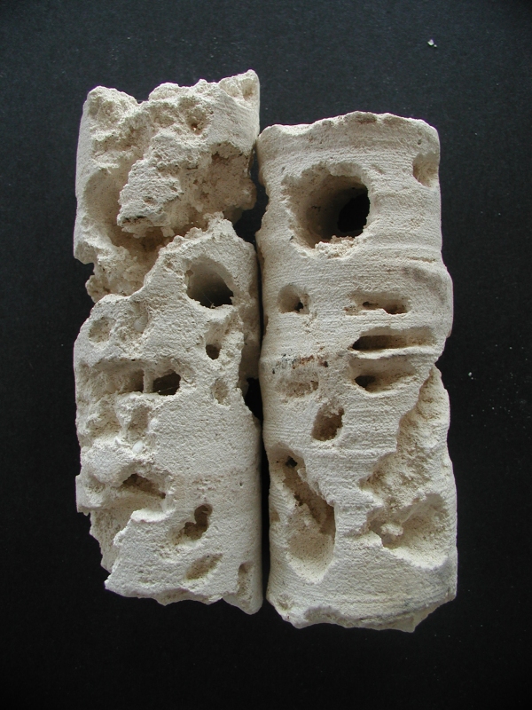
Evidence of subaerial erosion in Core 1.--
Figure 4. Solution channels and borings at minus 10 ft (left), and minus 16 ft, in core 1.
Our descriptive log for core-hole 1 shows evidence of subaerial erosion. The uppermost 2.0 ft consists of loose sand. Between -10 ft below mean sea level and -26.8 ft there was 85 per cent recovery of light grey limestone with small to moderate-sized (inch-sized) solution channels. (See Fig. 4). This unit probably represents lime mud or lime silt deposited offshore below wave base, as was observed in the Bimini environment by G. Friedman.9
From -26.8 ft to the bottom of the hole there was 25 to 50 percent recovery of grey to white limestone containing considerable solution cavities and channels up to one-half inch in diameter. At minus 35 to minus 36.6 ft a layer of cemented shell hash was recovered.
Between -41 and -47 ft the core barrel returned 50% of a layer of cemented shells with numerous solution cavities. And from -47 ft to -51.5 ft the core barrel returned 90% of a layer of limestone with medium-sized shells and coral fragments. Ninety per cent recovery of this stratum exhibited numerous solution cavities and channels, and medium-sized shells and coral fragments.
CONCLUSION
The gap of time at Bimini represented by missing rock strata and subaerial erosion is emblematic of a geologic disconformity. This stratigraphic feature is marked by evidence of erosion during a break in sedimentation, in which the bedding below the erosion surface is parallel to that above; that is, there has been no deformation of the lower series of beds prior to erosion.
Evidence of fossil coral ages, as backed up by a C-14 date, indicates that a considerable thickness of Pleistocene and Holocene strata is missing from the near-surface geologic section beneath Bimini. A reasonable implication of these missing rocks is that during a period of time covering perhaps 800,000 years -- or a minimum of 120,000 years at the least -- an ancient land surface in the Bimini area was above sea-level during times of the continental glaciations. This land surface could well have been inhabited by human beings.10
REFERENCES
- HARRISON, W., Nature, Vol. 230, No. 5292, pp. 287-289, April 2, 1971.
- American Association of Petroleum Geologists Bulletin, 1980, v. 64, n. 10, pp. 1634-1642.
- Fossil coral identifications were made by Prof. N. Noffke and graduate student D. Bower, School of Oceanography, Old Dominion University, Norfolk, VA
- M. TOSCANO and I. MACINTYRE, Coral Reefs, Oct. 2003, pp. 257-270.
- R. Hatfield, Deputy Director, Beta Analytic, Inc., Miami, FL made the interpretations given here.
- E. Hoffman, 2007, Actlabs Report A07-3318.
- H. VEEH and TUREKIAN, K., 1968, Cobalt, silver, and uranium concentrations of reef-building corals in the Pacific Ocean, Limnology And Oceanography, v. 13, no. 2.
- B. Waller, Hydrologic Assoc., Miami, FL, 2002, written communication. U. Miami graduate student T. Manne logged the cores. Note that H2S was encountered at 90 ft in these two cores. Presence of this gas is similar to that found in an extremely active diagenetic zone around 320 ft deep at the ODP Site 1004 hole by G. Eberli, et al., in 1996, south of Bimini at 24.33N and 79.15W.
- G. FRIEDMAN, 1970, The Bahamas and southern Florida: A model for carbonate deposition, Shale Shaker, v. 21, no. 1, p. 8.
- J. Eagle provided considerable efforts and counsel during the field work.
A permit for coring was granted by the Government of the Bahamas, Ministry of Agriculture, Fisheries, and Local Government. Thanks to D. Choi for alerting me to the 1980 study by D. Beach and R. Ginsberg (reference 2 above).
BACK STORY
A “back story” is the history behind the situation extant at the start of the main story A Brief History Of One Man's Search For Atlantis The author of the attached paper (the main story) has been searching for evidence of rocks of Atlantis intermittently for over 50 years. But the fundamental requirements of right information, right time, right place, right equipment, and right people came together only in March of 2007. The information as to the right place to sample the potential rocks of Atlantis was given in the following portion of Edgar Cayce psychic reading 364-3, in 1932.
…while the destruction of this [Atlantean] continent and the peoples are far beyond any of that as has been kept as an absolute record, that record in the rocks [emphasis added] still remains…
The position as the continent Atlantis occupied, is that as between the Gulf of Mexico on the one hand - and the Mediterranean upon the other. Evidences of this lost civilization are to be found in the Pyrenees and Morocco on the one hand, British Honduras, Yucatan and America upon the other. There are some protruding portions within this that must have at one time or another been a portion of this great continent. The British West Indies or the Bahamas, and a portion of same that may be seen in the present - if the geological survey would be made in some of these - especially, or notably, in Bimini and in the Gulf Stream through this vicinity, these may be even yet determined.
As the main story implies, rocks of "Atlantis" were sampled in drill-cores taken by W. Harrison, and his colleague J. Eagle, from the bottom of the Bimini Inlet, in the Bahamas, on March 28, at 11:00 am, 2007.
(GPS coordinates were: N 25º 43 min. 9.4 sec; and W 79º 17 min. 55.6 sec.)
The key sentences in the abstract of the enclosed paper are these:
"...during a period of time covering perhaps 800,000 years -- or a minimum of 120,000 years at the least -- an ancient land surface in the Bimini area could have been above sea-level during the Pleistocene continental glaciations. This old land surface would have been available for human habitation for upwards of the last 120,000 years, at minimum."
This old, and shallow land surface (just 10-ft below mean sea level in the Bimini Inlet) could well be the ancient surface of "Atlantis," as mentioned above in Cayce reading 364-3.
An "Omen" Experienced At The Beginning Of TheRock-Coring Project In The Bimini Inlet?
Something unique happened when J. Eagle and I began drilling for possible Atlantean rocks on Bimini. What exactly took place? Something that only I experienced. Others of our group did not notice anything unusual.
When Jonathan and I had finished helping the crew prepare the drilling barge at the first rock-coring site, there was a pause before the actual drilling began. I moved to the back of the barge, to a relatively quiet area. There, I concentrated on making an internal affirmation, one that I had often made in the previous 50 years. It was simply, "Lord disclose to us anything you wish to have revealed about Atlantis at this time, as we begin our work." (The time was 9:00 am, March 28).
I did this with closed eyes and great concentration. When I opened my eyes again, I for some reason looked up. The sky was clear except for a stunningly beautiful ring around the Sun. Initially, I told myself that there was some unusual atmospheric condition that had produced the ring. But then I felt the Sun and its ring in its gorgeous manifestation. This feeling was something like the one that a person experiences during a total eclipse of the Sun. I mentioned this to Jonathan, and suggested that the display might be a positive omen of sorts, one indicating that something of true value would be revealed to us in our rock-sampling effort.
Little did we realize then that the "something of value" would be our eventual determination that rocks of the ancient surface of Atlantis existed there in our very first drill hole, only ten feet below sea-level in waters of the Bimini Inlet.
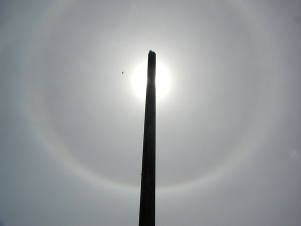
The Sun's ring as photographed by Jonathan with the drilling barge's mast in the foreground
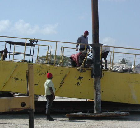
Workers attaching spuds (legs) to the barge in a North Bimini drydock
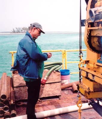
J. Eagle taking a positional fix on the drilling barge
with a handheld GPS
with a handheld GPS
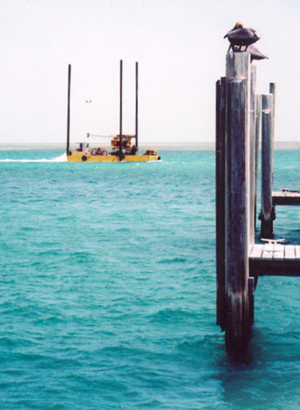
The drilling barge motoring to its first drilling location after being assembled.
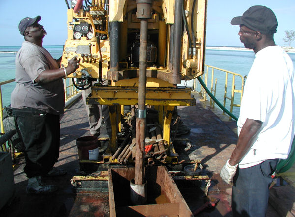
"Tiny" (on left) and his cousin, setting up to attach a section of drill pipe to the end of the drill rotor
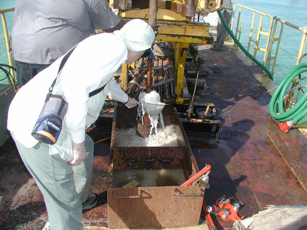
W. Harrison sampling rock cuttings brought up in drilling water return-flow,
as the drill bit penetrates rock formations beneath the Bimini Inlet floor.
as the drill bit penetrates rock formations beneath the Bimini Inlet floor.
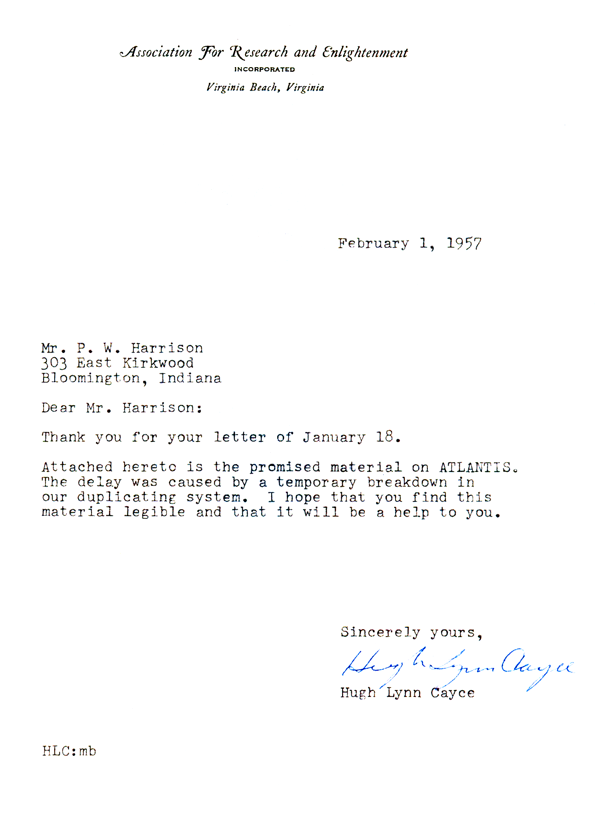
W. Harrison's personal search for Atlantis began with the Edgar Cayce readings supplied to him by Cayce's eldest son, Hugh Lynn, in 1957.