
Archived Articles
Which Portions Of Ohio, Indiana,
And Illinois Will Be Safety Lands?
And Illinois Will Be Safety Lands?
Introduction
This past Thanksgiving holiday I took an automobile trip from Virginia, to Waterloo, Illinois, near St. Louis. This took me across the southern portions of the Cincinnati arch (in Kentucky), the Wabash Valley seismic zone in Indiana, and part of the Rough Creek graben in Illinois.
In addition to the productive farms and woodlands, one could see numbers of small oil wells, some abandoned and some pumping. I was reminded of Thomas Gold's hypothesis that rising primordial gases from deep within the Earth cause earthquakes. These also could be the same gases that produce oil fields like those of the Illinois Basin. (See our Subscribers Only article on the subject.) It was difficult to imagine that in 1811 and 1812 three enormous earthquakes shook the foundations of the very region that I was traversing. These quakes originated in the Mew Madrid, Missouri, seismic zone (NMSZ).
That the NMSZ is capable of major earthquakes and widespread, massive damage was decisively proven almost 200 years ago during a five-month period, from December 16, 1811, to the following May, 1812. More than 2,000 earthquakes originated from the NMSZ during that span of time, five of which are thought to have been near 8.0 in magnitude, 15 are considered to have been of magnitudes 6.7 to 7.7, and another 35 were probably 5.9 in magnitude or slightly more.
The Reading Mentioning Coming
Disturbances To The Central U.S.
In 1941, four months before WWII began, Mrs. 1152 was given a reading that is probably the second best of all of the Earth changes readings. This woman was given a false name by Hutton to protect her true identity in the article, “Mrs. Whitsell's 1936 Christmas, and 1941 Earth-Change Readings.”
Mrs. Whitsell had been concerned about living in New York City. She had asked that sleeping Cayce address the advisability of her continuing to live there. The following comprehensive response was channeled by Cayce from a source believed to be truthful. As we said in our summary evaluation for reading 1152-11, this reading ranks a close second to 3976-15 in truthfulness and reliability for predicting potential Earth changes. And like 3976-15, which correctly predicted the rise and fall of Hitler, the [1152-11 reading] correctly predicted the time of the end of WWII and establishment of the United Nations in 1944 and 1945.
Here is the relevant “safety lands” part of the 1152-11 reading.
No wonder, then, that the entity feels the need, the necessity for change of central location. For, many portions of the east coast will be disturbed, as well as many portions of the west coast, as well as the central portion of the U.S. In the next few years lands will appear in the Atlantic as well as in the Pacific. And what is the coast line now of many a land will be the bed of the ocean. Even many of the battle fields of the present will be ocean, will be the seas, the bays, the lands over which the NEW order will carry on their trade as one with another. Portions of the now east coast of New York, or New York City itself, will in the main disappear. This will be another generation, though, here; while the southern portions of Carolina, Georgia - these will disappear. This will be much sooner. The waters of the lakes will empty into the Gulf, rather than the waterway over which such discussions have been recently made. It would be well if the waterway were prepared, but not for that purpose for which it is at present being considered. Then the area where the entity is now located [Virginia Beach for rdg.] will be among the safety lands, as will be portions [emphasis added by Hutton] of what is now Ohio, Indiana and Illinois, and much of the southern portion of Canada and the eastern portion of Canada; while the western land - much of that is to be disturbed – in this land - as, of course, much in other lands.
1152-11; August 13, 1941
Which Portions?
We have already dealt with the Virginia Beach area safety land in a separate article. What we would like to know now is just what portions of the Ohio-Indiana-Illinois (OH-IN-IL) region are geologically suitable for the safety-land designation.
It seems logical to begin our considerations by first eliminating geologically unsuitable areas.
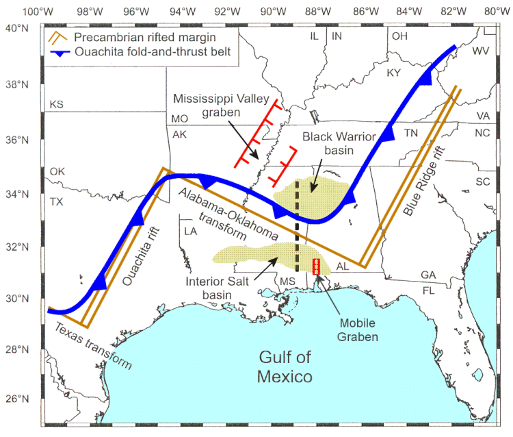 Fig 1. Simplified tectonic map of the southeastern United States (after Harry et al., 20031).
 Earthquake prone areas. The southern portions of Indiana and Illinois, although containing many areas of rich farmland for food production, are just too close to the New Madrid and Wabash Valley Fault Zones to allow us to accept them as safe for any period of accelerated Earth changes.Note the NE-SW trending walls of the Mississippi Valley graben on Figure 1. [A graben is an elongate, relatively depressed crustal unit or block that is bounded by faults on its long sides.] This ancient feature is the big troublemaker in the east-central U.S., having produced three major or great earthquakes in 1811 and 1812 in what is referred to as the Mew Madrid, Missouri, Seismic Zone.
As an aside, note the location of the Black Warrior basin in northwestern Alabama. It coincides with the part of Alabama (and by extension, Mississippi) that was to experience “physical changes in the Earth's surface” in reading 311-8.
Q) Are there to be physical changes in the Earth's surface in Alabama? A) Not for some period yet.
Q) When will the changes begin? A) Thirty-six to thirty-eight.
Q) What part of the state will be affected? A) The northwestern part, and the extreme southwestern part.
311-9; August 6, 1932
This was followed up in a reading three months later.
Q) Are the physical changes in Alabama predicted for 1936-38 to be gradual or sudden changes?
A) Gradual.
Q) What form will they take?
A) To be sure, that may depend upon much that deals with the metaphysical, as well as to that people called actual or in truth! for, as understood - or should be by the entity - there are those conditions that in the activity of individuals, in line of thought and endeavor, keep oft many a city and many a land intact through their application of the spiritual laws in their associations with individuals. This will take more of the form here in the change, as we find, through the sinking of portions with the following up of the inundations by this overflow.
311-10; November 19, 1932
Now, in the extreme southwestern part of Alabama we find the Mobile graben (Fig. 1), which extends roughly north-south from just north of Mobile Bay. This graben reveals a structural feature of the crust that tends to subside, as does also the Black Warrior basin and the Mississippi Valley graben. That is, grabens and basins, by their very nature are subsiding at various rates.
What do we want to look for in a time of accelerated Earth changes concomitant to the crustal movements induced by pole shift? We want to identify crustal units that tend to remain stable, or even rise, over geologic time. These are broad, open folds on a regional scale that usually reflect doming of basement rock. Such units are called simply arches, and there are two significant arches in portions of the OH-IN-IL safety land. They are the Kankakee and Cincinnati arches (Fig. 2).
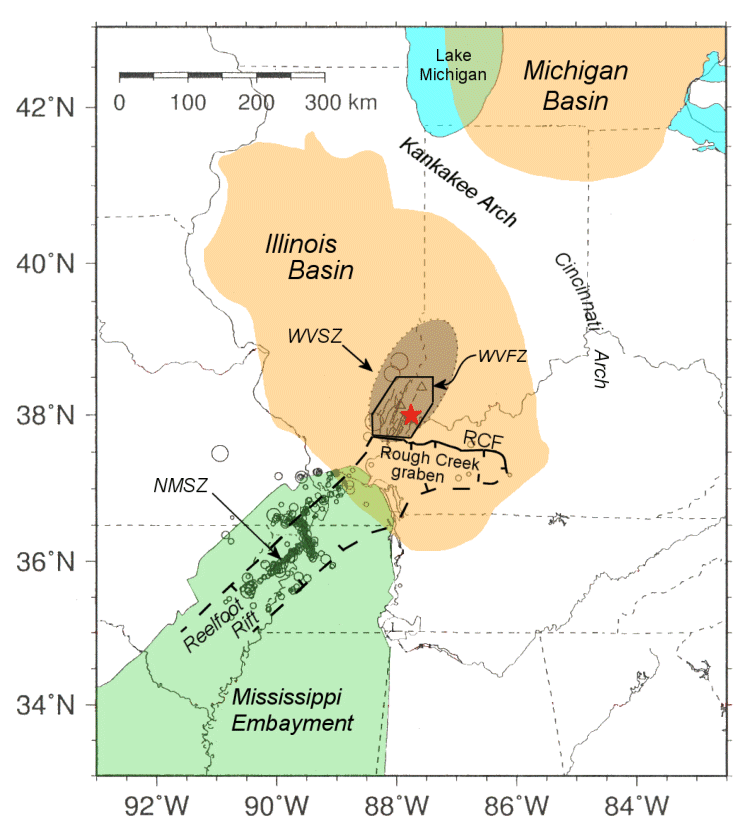 Fig. 2. The New Madrid Seismic Zone earthquake epicentral area, showing major surrounding geologic features. The epicenter of the 18 June 2002 Caborn, Indiana, quake is plotted with a red star.
 WVSZ = Wabash Valley Seismic Zone (shaded, elliptical area).
WVFZ = Wabash Valley Fault System.
Reelfoot Rift is indicated by heavy dashed lines.
The Rough Creek graben in western Kentucky separates the WVFS from the Reelfoot rift to the south.
The Rough Creek fault is indicated by the solid line (RCF). After Kim, W.-Y., 2003.2
Current Geological Thought About The Earthquake Hazards
Originating In the New Madrid Fault Zone
Geologists S. Marshak and T. Paulsen of the University of Illinois in Urbana-Champaign say that there are over a hundred fault and fold zones in the midcontinental U.S. They argue that most were created by ancient rifting events similar to the one that formed the New Madrid Seismic Zone. Marshak thinks that although the chance of another quake such as those in the 19th century is low, the possibility cannot be ruled out. M. Tuttle and five other authors, however, in their comprehensive 2002 study entitled, “The earthquake potential of the New Madrid seismic zone,” concluded that on the basis of a minimum recurrence rate of 200 years, “we are now entering the period during which the next 1811-1812-type event could occur.”3
Because the NMSZ is the primary source zone for damaging earthquakes in the region, it is instructive to look at the possible effects of an earthquake as severe as the initial 1811 quake in the three-quake series that occurred along the Mew Madrid seismic zone. Figure 3 shows contours for the probable distribution of Modified Mercalli Intensity (MMI) values for such a quake.
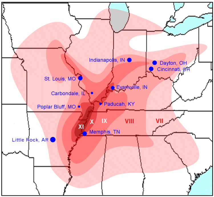 Fig. 3. Estimated distributions of values of Modified Mercalli quake intensities for a repeat of the first major quake of the three-quake New Madrid series in 1811-1812. (Source: USGS)
 Table 1 provides descriptions for each MMI grade scale from VII to XII. MMI values of VIII and above indicate areas of questionable safety, when disturbances to “the central portion of the U.S.” begin. For safe living, this eliminates the lower one-third (roughly) of Ohio, the lower half of Indiana, and the lower one-fourth to one-third of Illinois. The MMI area labeled VII should be safe enough, however, for carrying out most all normal activities.
|
FOUR TYPES OF MASONRY
|
Summary
There is much more that could be written about the earthquake hazard zones in and around the OH-IN-IL region. We have covered the effects of the most significant earthquake source zone, however, and it seems best to leave things there. The effects of other earthquake source areas are eclipsed by those originating in the NMSZ.
Figure 2 indicates where the important arches are located. Arch safety, in terms of closeness to the NMSZ, must take into consideration the MMI values that cross the arches. For example, the Cincinnati Arch in the vicinity of Cincinnati and Dayton, Ohio, is safe only in the sense of itself not being an earthquake source zone. It is not safe, however, in the context of reading 1152-11, because a safe portion of the three-state safety land cannot lie in the zone of value VIII for Modified Mercalli earthquake intensity.
Other potentially disruptive earthquake source zones have been identified in northwestern Ohio (centered on Anna, Ohio), and in northwestern Illinois. These source zones are limited in area and pale in strength by comparison to that of the New Madrid seismic zone.
One must remember too that more than geological and seismological factors will define portions of the OH-IN-IL region that are “safe” for the Earth-change days ahead. One must think of the life-supporting factors of water supply, good soils for agriculture, and the presence of a majority of non-violent people of right mind and spirit.
- Harry, D.L., et al., 2003, Early Paleozoic transform-margin structure beneath the Mississippi coastal plain, southeast United States, Geology, v. 31, no. 11, p. 969-972.
- Kim, W.-Y., The June 2002 Caborn, Indiana, earthquake: Reactivation of ancient rift in the Wabash Valley Seismic Zone?, Bull. Seismological Soc. America, v. 93, no. 5, p. 2201-2211.
- M. Tuttle, et al., 2002, Bull. Seismological Soc. Amer., v. 92, no. 6, pp. 2080-2089.