
Archived Articles
A Small Pole Shift Can Produce Most,
If Not All, Of The Earth Changes
Predicted In Cayce's Readings
If Not All, Of The Earth Changes
Predicted In Cayce's Readings
Introduction
A reading given by Edgar Cayce in 1933 says that we are living -- right now -- at a time when "the change" is imminent in the Earth,
which change, we see begins in '58 and ends with the changes wrought in the upheavals and the shifting of the poles, as begins the reign in '98 of those influences that have been kept by those sojourners in this land of the Semitic peoples.
(378-16)
The following exchange in reading 826-8 sheds further light on the date of the shifting of the poles:
Q. What great change or the beginning of what change, if any, is to take place in the Earth in the year 2000 to 2001 A.D.?
A. When there is a shifting of the poles. Or a new cycle begins.
(826-8).
When speculating about the path of the upcoming pole shift, it makes sense to start with available scientific information on the present drift-direction of the north pole. (Data for the south pole are unavailable, but a movement direction identical to that of the north pole is assumed throughout the article). It is much harder to speculate about the distance of a pole shift than it is to estimate its direction. The approach used here is, wherever possible, to work backward from Earth-change descriptions in the Cayce readings to infer the minimum degree of pole shift that could produce those changes. Positing too large a pole shift will give outrageously improbable Earth-change results.
What we are looking for is a credible first approximation to the minimum degree of pole shift necessary to achieve all of the Earth changes predicted in Cayce's readings. Wild speculations about pole shifts of many degrees of latitude are not necessary, and they raise more problems than they solve. Preservation of the Earth's ice sheets, for example, cannot be accommodated by a pole shift of more than about 10 degrees. Ice in Greenland and Antarctica has been in place for more than 125,000 years, and so past pole shifts inferred from the readings could not have amounted to more than a few degrees, to preserve the ice during this period of time.
Present Drift of the North Pole
Scientists1 analyzingobservations of polar wander conclude that between 1900 and 1992, the Earth's pole of rotation has drifted southward along the 79.2 ± 0.2°W longitude; that is, roughly toward Toronto, Ontario. What is involved here is a change in pole position relative to fixed stars or to far-distant pulsars. The speed of this drift, or pole shift, approximates 33 ft per century. It is due to "some sort of mass redistribution" within the Earth.2 Thus, the Earth is currently undergoing a very slow shift in the average location of the north pole of the rotation axis.
Three Types of Pole Shift
The ongoing drift of the north pole could be explained by three possible mechanisms of pole shift. In the first mechanism, all the layers of the Earth remain together and the axis and entire spinning globe tilts relative to the plane of Earth's orbit around the sun. (See Fig. 1, A). This results in the north and south poles assuming new locations relative to the positions of fixed stars. Note that in this type of pole shift there is no displacement of the equatorial bulge during axis shift. Centrifugal forces that produce the equatorial-radius bulge of 13.5 miles relative to the polar radius are the same under both the former and new axis orientations. Thus, sea level, and the distribution of land and sea areas, are unchanged under both the old and new pole locations.
Any observed drift of the poles would then be due only to continental drift. But as stated by Kerr, "By the standards of continental drift, that [pole motion of 10 meters per century toward eastern Canada] is a gallop, but the [continental] drift of North America had nothing to do with it. Instead, the north pole appears to be wandering."
Fig. 1. Diagram A shows a whole-Earth axis shift for a cross-section of Earth through its rotation axis. N' and S' are the north and south poles after the axis shift. The shift angle is N' ON (or S' OS). Diagram B shows a mantle-slip type of pole shift in which the spin axis of Earth's dense, spinning, inner iron core remains fixed relative to the stars after the entire mantle and crust have slipped as one unit over the surface of the liquid outer core. The surficial Earth-change consequences of a mantle-slip type of pole shift are immensely greater than those experienced by a whole-Earth type of axis shift. And, while the points on the Earth's surface where the spin axis penetrates the surface remain the same for the whole-Earth type of shift, they occupy new positions on Earth's surface for a mantle-slip type of shift.
A second type of axis shift would involve no change in the direction of the axis relative to fixed stars. But here, a slight shift in masses either upon or within the Earth would cause the globe to roll beneath the rigidly spinning axis so that different places on Earth's surface would be at the poles. To visualize this process, imagine a ball set spinning on ice with a silver dollar, a quarter, and a dime taped at different places on its surface. The ball would orient itself so that the greatest masses were at the equator, where the greatest centrifugal forces occurred. If the quarter were then removed, the unbalanced ball would reorient itself so that a new equator would be on line with the silver dollar and the dime. The axis of rotation would still point in the original direction, but the poles would have shifted.
The main obstacle to such an axis shift is the stabilizing effect of Earth's equatorial bulge. Extra mass around the equator - rotating as it does at a very high speed - acts like the rim of a gyroscope to keep Earth on a steady axis. Nineteenth century greats of geology like James Clerk Maxwell and Sir George Darwin considered the problem and concluded that the stabilization of the equatorial bulge was so great that no conceivable force originating on or within the Earth could make it shift on its axis. We agree.
Consider now the third mechanism capable of producing "pole shift." This is our preferred mechanism and it will be referred to as the mantle-slip mechanism. Such a term is shorthand for "the slip of the Earth's crust (lithosphere) and mantle over the liquid core (or perhaps some other easily-yielding surface above the core)." [Note that when referring to pole shift, geoscientists assume for their own convenience the perspective in which Earth is fixed but the poles move.]
As shown in Fig. 1, B, Earth's spin axis remains unaffected, defined as it is with respect to the dense, spinning, iron core. The north pole of rotation moves across Earth's surface as the lithosphere and mantle slip over the core's surface. (Earth's outer core is about 1,400 miles thick. It consists of fluid iron that is thought to have a viscosity close to that of water.) This type of mantle-slip pole shift also causes the pre-shift equator to move over the surface of the Earth. As the pre-shift equator moves into new regions of Earth's surface, these regions begin to experience changes in centrifugal forces and sea levels. This leads to new distributions of land and sea, and to crustal tectonic movements.
When trying to determine the consequences of a predicted shift of the poles, it is of prime importance to specify which of the two types of shift are expected. In 2001, we expect the type shown in Fig. 1-B. Only a mantle-slip type of shift will engender the many catastrophic Earth-change events predicted to occur during the upcoming pole shift. A whole-Earth axis shift, however, primarily
Definitions of "Axis Shift" and "Pole Shift"
Axis shift. An axis shift involves a change in the orientation of Earth's rotation axis with reference to the fixed stars. It does not involve slippage of Earth's layers over one another. Thus, we term an axis shift a "whole-Earth axis shift." If such a shift occurs, it would probably cause few significant sea-level changes, or tectonic or volcanic Earth changes; climatic changes would be the major type of "changes" generated by a whole-Earth axis shift. Thus, while axis shifts may have been involved in readings 364-13 and 5748-6 below, this type of whole-Earth axis shift certainly does not seem to be the kind of pole shift predicted for 2000-2001 (see reading 826-8 at the beginning, where the upcoming shift is referred to as "a poles").
You see, with the changes - when there came the uprisings in the Atlantean land, and the sojourning southward -- with the turning of the axis, the white and yellow races came more into that portion of Egypt, India, Persia and Arabia.
364-13; November 17, 1932
Q What will be the type and extent of the upheaval in '36?
A The wars, the upheavals in the interior of the Earth, and the shifting of same by the differentiation in the axis as respecting the positions from the Polaris center.
5748-6
Pole shift. As used in this article, a pole shift refers to a relatively sudden change in the location of the imaginary piercing point of Earth's rotation axis at the surface of the globe. Such a shift is brought about by differential movement between the Earth's crust -- and including some (or all) of the material of the mantle -- with respect to the deeper layers of our planet. It is these deeper layers whose mass and momentum govern planetary rotation. This type of shift has profound implications for the redistribution of centrifugal forces over Earth's surface, and for sea-level changes worldwide, new distributions of land and sea areas, and extreme geotectonic events.
Approach To Determining The Path Of The Pole Shift
Our approach to determination of the shift path will be to assume that the current drift direction of the north pole will be maintained, but that the drift will suddenly accelerate into a full "shift."
Determining The Consequences of Mantle-Slip Pole Shift
As for the consequences of a mantle-slip pole shift, it seems that a retired engineer may have come pretty close to explaining the possibilities. Mac B. Strain published his approach to determining the consequences of an axisshift in 1997. His book is entitled, "The Earth's Shifting Axis."3 Strain considered only a one-degree shift in the pole, not the 10-degree shift that I had suggested in Coming Earth Changes. Also, Strain's axis-shift direction follows a path down the 70°W meridian, not the 79.2°W meridian determined by Gross and Vondrák two years after Strain had published his book. For our first approximation to pole-shift consequences (i.e., Earth changes) we will assume that Strain's 70° W shift path is equivalent to the Vondrák 79.2°W drift path.
In presenting his dynamic axis theory, Strain first addressed the response of ocean waters to changes in centrifugal forces created by a shift of the spin axis, while assuming all other layers of the upper Earth were rigid. His calculations for a 1° axis shift of the north pole southward along the 70°W meridian were intended only as an illustration of how the oceans would respond to an axis shift, not as a specific prediction. Strain then addressed the response of Earth's plastic and liquid layers below Earth's crust to changes in centrifugal forces. Unfortunately, there is an unknown lag time between ocean-water response and the much slower response of Earth's liquid outer core, plastic mantle, and semi-brittle crust to a shift-induced change in centrifugal forces. The response of the aqueous geoid4 at any point on Earth can be calculated to within a foot or less. The crust's response, however, depends upon many unknown factors, such as the rate of deformation of inner Earth materials to newly-imposed centrifugal forces, and the thickness, weight, and strength of the crust itself. Theoretically, given enough time, the crust and the sea-level geoid will respond equally and there will be no changes in land elevations. Initially, however, the land elevation changes that we calculate herein may all be expected to occur, immediately after a pole shift.
As we shall see, most of the Earth changes mentioned in the readings follow from the crustal deformations and changes in sea-level predicted by Strain's analysis of the consequences of his one-degree axis shift.
Readers may be concerned that we use Strain's analysis of the Earth-change results of an axis shift to explain the Earth-change consequences of our mantle-slip type of pole shift. But it doesn't matter that Strain's axis-shift analysis is used for what we believe to be a physically impossible model for pole shift. This is so because his shift analysis methodology will yield the same consequences whether it is applied to either the second or the third type of pole shift, as discussed above "Three Types of Pole Shift."
Strain's Shift Methodology Applied to a One-Degree Pole Shift
To explain the effects of a mantle slip on Earth's crust, and the distribution of land and sea, we begin with the simple case of a one-degree shift in the latitude of the north pole, from 90°N to 89°N. The main points of Strain's analysis are as follows:
1) Consider a slice of the Earth through the rotation axis. This slice is described by a great circle on Earth's surface. Because the poles shift along this longitudinal (meridional) circle, we will refer to it as the shift meridian.
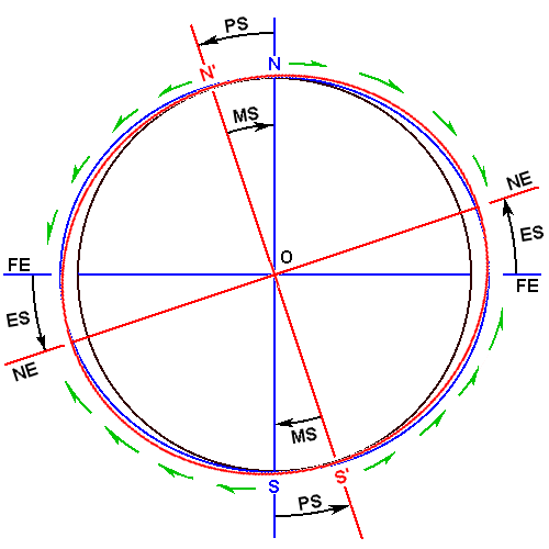
Fig. 2. Cross-section of the Earth showing two equatorial bulges along a shift-meridian great circle. The north and south poles have moved from N to N´, and S to S´, respectively, as the Earth's mantle has shifted 1° clockwise. Centrifugal forces thrust ocean waters toward the pre-and post-shift equators, forming equatorial bulges.
| PS= pole shift | MS = mantle slip | |
| NE = new equator | FE = former equator | |
| ES = equator shift | Arrows = centrifugal forces | |
| FE -NE = shift of equator and the equatorial bulge | ||
| blue circle = Pre-shift equatorial bulges | red circle = Post-shift equatorial bulges | |
2) Centrifugal forces produced by the spinning Earth cause ocean waters to move toward the equator. (See Fig. 2) An equatorial radius is about 13.5 miles (71,280 ft) longer than a polar radius. Earth's crust is also found to extend somewhat farther at the equator than it does along a polar radius. This is due to centrifugal force acting on molten or plastic mantle and (or) core material underlying the crust.
3) Assuming that the axial shift in Figure 2 is exactly one degree, Strain's analysis is now advanced by reference to Figure 3.
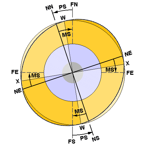 Fig. 3. Mechanism and consequences of a mantle-slip pole shift.
| NN-NS = Earth's rotation axis, fixed in space | ||
| FN = former north pole | NN = new north pole | |
| FE = former equator | NE = new, post-pole-shift equator | |
| PS = pole-shift track over Earth's surface | MS = mantle slip direction | |
| W, X = neutral meridional and equatorial great circle traces (theoretically, sea-level does not change at W or X, because latitudes have not changed there). | ||
Positive quadrants (see text) are W-FN-NE-X and W-FS-NE-X. They exhibit increased centrifugal forces, higher sea level, and, therefore, decreased elevation of land features relative to the mean-sea-level geoid. Negative quadrants exhibit lower sea level and elevated land surfaces.
Here we see that point FN at the ground surface on the shift meridian has moved from the former north pole to point NN, the location of the shifted pole. Sea level at NN is now suddenly lower than it was originally. Strain computes (in his Table B-1) that the lowering of the original (sea-level) geoid at NN is 65 ft. Note that Earth's geoid for the crust or ocean surface at the new south pole (NS) is also 65 ft lower than it was before mantle slip. At this point, it is useful to explain Strain's term, quadrant.
Following a pole shift, two quadrants of Earth's surface will experience lower latitudes at all pre-shift points. These points will also experience higher sea levels and flooding. Such quadrants are referred to as positive quadrants. Such quadrants also display higher elevations of plastic or liquid mantle and core material that puts Earth's crust under tension.
The other two quadrants are termed negative quadrants. Points on Earth's surface prior to pole shift suddenly experience higher latitudes after the shift. This leads to lower sea levels at the post-shift points and to draining of lowlands. Beneath the crust, molten or plastic rock is slowly lowered as well, placing the crust under compressive forces.
Maximum changes in surface elevations occur at the center points of each quadrant; that is, at a point 45.5° north or south on a given shift meridian. Elevation changes decrease to zero at the meridional and equatorial great circles. For a rigid crust and a 1° pole shift, 1238 ft is the maximum elevation or lowering at the center point of each of Earth's four quadrants.
At latitudes all along the shift meridian between the new north pole and the new equator, it is now possible to compute the changes in surface elevations of the ocean or land. If we proceed along W-FN-NE-X, we see that former points between W and X are now, post-shift, experiencing higher elevations of the sea-level geoid, and lower land elevations, than they were before. These higher geoid elevations define a positive quadrant.
Again, negative quadrants, like X-FE-NN-W (Fig 3), are those in the direction of pole shift. There, centrifugal forces are reduced at former pre-shift points at all latitudes within the quadrant; sea level is lowered; and ocean water is withdrawn from portions of
Earth Changes Caused by a 1° Pole Shift to 89°N and 70°W
We now use Strain's example of a pole shift down the 70°W meridian of just one degree (to 89°N). This will allow us to see how the sea-level geoid changes correspond with several of the Earth changes mentioned in Cayce's readings. It matters only a little that Strain did not use Gross and Vondrák's estimate of 79.2°W for the present pole-drift direction in his analysis. The 9.2° difference has
Using the notion of geoid change discussed above, and the shift meridian values in Strain's Table B-1 (that assumes a rigid crust), it is possible to calculate approximate elevation changes for many points on Earth for a hypothetical 1° pole shift. It is fascinating to compare Strain's results with the Cayce readings' Earth changes. The comparisons are reminiscent of the story of the author who wrote about the sinking of the Titanic years before it happened. Strain is akin to that author, and it is about the readings' pole shift and Earth changes that he is writing -- before they happen.
Strain begins his analysis of the results of the pole shift with an examination of altered land and sea configurations. The shift meridian follows 70°W for the Western Hemisphere and 110°E for the Eastern Hemisphere. The continent of Asia falls into a "positive quadrant where the higher geoid floods much of the lowlands around the edge of the continent" (Strain, p. 38). This flooding of coastal lowlands around Asia includes the WWII-ravaged Pacific islands of Wake, Midway, Guam, Okinawa, and the Philippines. Included also are both WWII and later battlefield regions like Korea, China, Japan, Vietnam, Kuwait and the Persian Gulf countries. Tokyo would be 952 ft. lower than now, and so most of Japan's lowlands would be flooded. All of the former USSR war cities would be lowered (relative to a rising sea-level geoid) and some would be flooded. These results remind us of the following two
...what is the coastline now of many a land will be the bed of the ocean. Even many of the battle fields of the present will be ocean, will be the seas, the bays, the lands over which the NEW order will carry on their trade as one with another.
1152-11; August 13, 1941
The greater portion of Japan must go into the sea.
3976-15; January 19, 1934
Strain's analysis of sea-level changes shows that almost all of North America falls into a negative quadrant. The lowered geoid in this quadrant exposes most of the present continental shelves. Because the west coast is more than 45° of longitude west of the shift meridian, and because the continental shelf is narrow, the alignment of the new coastline there is rather similar to the present one. Puget Sound and San Francisco Bay become drained and Lower California widens a bit more than lands to the north. According to Strain's computations, San Francisco will rise 798 ft, Seattle 821 ft, Los Angeles 817 ft, and San Diego 804 ft. Continental shelves offshore of these cities would be exposed down to a depth equal to Strain's predicted "elevation" values. For example, the shelf off San Francisco would be exposed down to 798 ft below present sea level.
As I mentioned in Coming Earth Changes, in reading 509-1 we have an intimation that in the near future the Santa Rosa/Petaluma area of California will be "fading into Mu, or joining with [formerly submerged land of] the Pacific lithospheric plate." Here's the relevant reading fragment:
And the entity was among those that - in what is not far from that land in which the entity in this sojourn first saw the light [Petaluma, CA] - (that must in the near future fade again into those joinings with the land of Mu) - established a temple of worship for those that escaped from the turmoils of the shifting of the Earth at that particular period.
We may presume here that "joinings" with the land of Mu simply means that continental shelf land suddenly exposed off California will be seen as merging with that of the original, pre-pole-shift California landscape. Remember, too, this reading
The early portion [of the Earth changes] will see a change in the physical aspect of the west coast of America.
3976-15; January 19, 1934
Strain now continues with the words quoted below, which contain several correspondences with several other Earth-change readings:
"The New Honduras and Nicaragua east coasts of Central America extend to the east for 100-200 miles. The Yucatan Peninsula extends about two degrees further north. The continental shelf off the east Texas and south Louisiana coasts are drained to move the coastline out about two degrees into the Gulf of Mexico. Florida picks up more than its present width from the Gulf of Mexico, while extending the state south to below the Florida Keys. The east coast of the United States from Florida to New Jersey gains about one degree of continental shelf lands from the Atlantic. An area about the size of Pennsylvania is added off Cape Cod as Georges Banks is drained. Even more land appends to Nova Scotia by exposing the Sable Island Bank. Over 300 miles of new continent are added to the east of Newfoundland as the lowered geoid exposes the Grand Banks... An island about the same size as Florida forms by the drainage of the Great Bahama Bank."
The foregoing exposed sea-floors would be created by the draining of continental shelves, and all of the emergence of lands would be due to the mere 1° pole shift. Assuming that the crust in the areas just mentioned is rigid, which it is not, Panama City would rise (relative to the post-shift sea level) some 1030 ft, Tampa 999 ft, Miami 953 ft, Jacksonville 1045 ft, Charleston 1110 ft, Norfolk 1180 ft, New York City 1222 ft, Boston 1228 ft, and Halifax 1230 ft. More later about these seemingly excessive east coast elevation changes.
Here again we see clear correspondences
Land will appear off the east coast of America... There will be new lands seen off the Caribbean Sea, and DRY land will appear.
3976-15; January 19, 1934
In the next few years lands will appear in the Atlantic as well as in the Pacific.
1152-11; August 13, 1941
Then, with the leavings of the civilization in Atlantis (in Poseidia, more specific), Iltar - with a group of followers that had been of the household of Atlan, the followers of the worship of the ONE with some ten individuals - left this land Poseidia, and came westward, entering what would now be a portion of Yucatan. And there began, with the activities of the peoples there, the development into a civilization that rose much in the same matter as that which had been in the Atlantean land. Others had left the land later. Others had left earlier. There had been the upheavals also from the land of Mu, or Lemuria, and these had their part in the changing, or there was the injection of their tenets in the varied portions of the land - which was much greater in extent until the final upheaval of Atlantis, or the islands that were later upheaved, when much of the contour of the land in Central America and Mexico was changed to that similar in outline to that which may be seen in the present.
The first temples that were erected by Iltar and his followers were destroyed at the period of change physically in the contours of the land. That now being found, and a portion already discovered that has laid in waste for many centuries, was then a combination of those peoples from Mu, Oz and Atlantis.
Q In which pyramid or temple are the records mentioned in the readings given through this channel on Atlantis, in April, 1932?
A As given, that temple was destroyed at the time there was the last destruction in Atlantis.
Yet, as time draws nigh when changes are to come about, there may be the opening of those three places where the records are one, to those that are the initiates in the knowledge of the One God:
The temple by Iltar will then rise again. Also there will be the opening of the temple or hall of records in Egypt, and those records that were put into the heart of the Atlantean land may also be found there - that have been kept, for those that are of that group.
The RECORDS are ONE.
5750-1; November 12, 1933
This last reading clearly indicates to me, and a few others, that Iltar's temple that contains the RECORDS was destroyed, is now underwater, but will rise again. What we're saying today is that the coming pole shift will so change the sea-level geoid that the continental shelf off Yucatan will be drained, Iltar's temple remains will be exposed, and the RECORDS will be found.
Pole-Shift Tilting of The Great Lakes
One of the most interesting comparisons between Strain's pole-shift calculations and the Cayce Earth-change readings has to do with the flow of water out of the Great Lakes Region (Fig. 4). The reading of interest (1152-11; August 13, 1941) states that:
The waters of the lakes [Great Lakes] will empty into the Gulf [Gulf of Mexico], rather than the waterway over which such discussions have been recently made [St. Lawrence Seaway].
It has been known since the early 1930s that Earth's crust in the vicinity of the Great Lakes had been tilting gradually toward the southwest. This is due to the rebound of Earth's crust and mantle - increasing in a northeasterly direction across the Great Lakes region - since melting of the last ice sheet. The southwesterly tilting is still in progress, at a rate of about five inches per hundred miles per century. Small as this rate seems to be, in only 1600 years it would cause the upper Great Lakes [Superior, Huron, and Michigan] to discharge through the Chicago River into the Illinois-Mississippi drainage and onward to the Gulf of Mexico. But in addition to this trend, let's now superimpose the effects of the 1° pole shift on the geoid across the region.
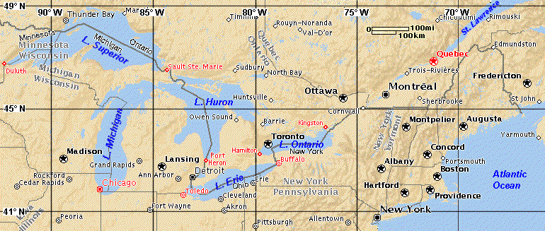 Fig. 4. Map of the Great Lakes Region.
Ground-surface and lake-water surface elevation changes relative to the post-shift geoid in the Great Lakes Region (Fig. 4) demonstrate the effects of the pole shift on the flow of lake waters.
Following Strain's analysis (1997, p. 84), the lowered geoid drainage results in the St. Lawrence River eroding a gorge in the river bottom 1,229 feet above post-shift sea level, where the river crosses the 70th meridian east of Quebec (city). The riverbanks at Quebec are elevated above the geoid by 1,237 ft. This is three feet higher than the elevation at the 70°W shift meridian because Quebec is slightly closer to the 45°N latitude. The 45.5° latitude marks the maximum elevation change on the shift meridian.
Shorelines and water surfaces at the east end of Lake Ontario, near Kingston, are raised from 1,236 to 1,482 ft relative to the new geodetic sea level. This indicates that Lake Ontario must be 15 ft deeper at the west end before it flows out over the higher post-shift east end. Thus, Lake Ontario no longer flows east. The east end of Lake Erie at Buffalo has a new elevation relative to post-shift sea level of 1,792 ft (571 ft pre-shift elevation plus 1,221 ft from the lowered, post-shift geoid). Lake Erie water now flows west toward Toledo. Chicago, on Lake Michigan, has to be 29 ft higher to match the post-shift elevation of Lake Huron. But it is not, and Lake Huron then flows into Lake Michigan, resulting in a 29-ft rise at Chicago. This rise in water level will cause Lake Michigan to overflow into the Chicago River, and then down the Des Plaines, Illinois, and Mississippi Rivers to the Gulf of Mexico. Whether Lake Superior will flow into Lake Huron is problematical at this stage of Strain's analysis.
In reviewing the Great Lakes region work done by Strain, it is clear that this is one region in which the selection of the shift meridian may have an important effect on post-shift elevation changes. Different geoid elevations may affect flow directions differently. For example, if the 79.2°W drift path of Gross and Vondrák5 is chosen for the shift meridian, the results of the geoid shift analysis may have slightly different implications for the flow of waters in Lakes Erie and Ontario than was determined by Strain for a 70° shift meridian.
Before continuing our comparisons it is important that we note a few Earth-change elevations that do not °pole-shift speculations.
Geoid Elevation Changes That Do Not Compare Well With The Readings
Consider this reading:
Portions of the now east coast of New York, or New York City itself, will in the main disappear. This will be another generation, though, here; while the southern portions of Carolina, Georgia - these will disappear. This will be much sooner.
1152-11; August 13, 1941
If New York City will in the main disappear, and the southern portions of Carolina and Georgia are to disappear even sooner, how can that happen if Strain's calculations for the U. S. Atlantic coast are correct? He finds Charleston would be elevated by reference to the post-shift, sea-level geoid by 1110 ft, Norfolk by 1183 ft, and New York City by 1222 ft. But the readings require New York and Charleston/Savannah to sink somewhat and Norfolk to stay about the same in elevation. It would seem that special geological conditions exist in the New York and Georgia areas. Indeed, the following reading implies that some special conditions are to be found, at least along the North Atlantic seaboard.
Q Will there be any physical changes in the Earth's surface in North America? If so, what sections will be affected, and how?
A All over the country we will find many physical changes of a minor or greater degree. The greater change, as we will find, in America, will be the North Atlantic Seaboard. Watch New York! Connecticut, and the like.
Q When will this be?
A In this period. As to just when -
311-8; April 9, 1932
Special East Coast Geologic Conditions That May Affect Strain's Predictions
There is considerable complexity to the movements of buried blocks of Earth's crust along the U. S. east coast, including "the North Atlantic Seaboard" mentioned above. Please refer now to Figure 5.We can perhaps understand the prediction in 1152-11 to the effect that the southern portions of Carolina and Georgia will disappear sooner than New York City if we realize that it's all a matter of knowing enough about the structure of the buried bedrock in both places.
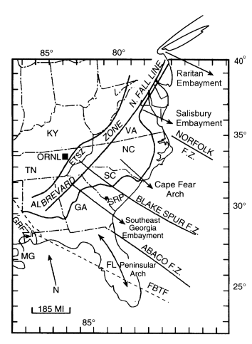
Figure 5. Map of the southeastern United States showing axes of embayments (see text) in the ancient shoreline of the North American continent. Major areas of seismicity are related to these gradually subsiding embayments; minor activity occurs on intervening arches. Trends of major fracture zones mapped on the Atlantic Ocean floor are shown where they are interpreted to exist on shore. The Brevard zone involves strike-slip faulting paralleling the Appalachian trend that becomes the Northern Fall Line fault zone. Explanations: ETSZ = Eastern Tennessee Seismic Zone; ORNL = Oak Ridge National Laboratory; SRP = Savannah River Plant; F.Z. -fracture zone; MG = Mobile Graben; GRFZ= Gulf Rim Fault Zone; FBTF = Florida-Bahamas Transfer Fault (interpreted); solid line near coast = generalized contact between Cretaceous and Tertiary coastal plain deposits; solid line interior= western side Valley and Ridge province.
As mentioned in my book, Coming Earth Changes (p. 102),
"A broad look at subsidence in the belt of Atlantic coastal states shows that areas of subsidence coincide with embayments along the ancient shoreline that existed in Late Cretaceous and Early Tertiary times. These embayments, or deep indentations of the ancient shoreline, coincide with broad, concave upward folds in the rocks (synclines) whose axes run transverse to the ancient shoreline. Embayment axes trend northwest, and the embayments have a history of subsidence since mid-Cretaceous times. The Raritan embayment is named after Raritan Bay, which lies off the south end of Staten Island, New York. The subsiding Raritan embayment is the site of the largest earthquake in southeastern New York....and earthquakes occur around it from northern New Jersey to southwest Connecticut. During the time of the larger earthquake last century Raritan Bay had an unusual subsidence rate. Thus, the ingredients for the natural destruction and disappearance of a major portion of New York City, by earthquake and subsidence, respectively, seem to be in place. Here again, we are struck by the ability of Cayce's psychic source to describe general geophysical conditions well before their discovery by scientists. And we see again that Edgar Cayce's Earth-change readings predict an acceleration in existing geological trends for portions of Connecticut and New York, including New York City."
What might have Cayce's psychic source for reading 1152-11 been seeing as the fundamental tectonic reason behind the predictions of subsidence of the southeast coast from about Charleston southward to the Georgia-Florida line? This stretch of coast is bounded by projections of two northwest-trending fracture zones that occur on the floor of the western Atlantic Ocean. To the north, the Blake Spur Fracture Zone is believed to coincide with the Charleston Seismic Zone, while to the south, a northwest-trending fault zone beneath the coastal plain sediments of southeast Georgia coincides with the landward projection of the Abaco [also called the Jacksonville] fracture zone. The southeast Georgia embayment appears to lie over a crustal block dropped between the two major fracture zones. Coastal seismicity is concentrated at the flanks of the Southeast Georgia embayment, which is (relatively) subsiding at present.
"And so here we have 1) bounding, northwest-trending fracture zones and 2) a gradually subsiding embayment, as the tectonic prerequisites for submergence of "the southern portions of Carolina, Georgia" as described by Cayce's psychic source. And if mantle movements associated with an oncoming pole shift begin to raise the sea floor in the Atlantic, as per reading 3976-15, off the U. S. east coast, one might well expect an acceleration of some of the existing long-term trends in coastal subsidence along the present Atlantic seaboard. This could be especially true for such ancient synclines as the Raritan and southeast Georgia embayments."
Strain points out (p. 56) that minor sags in the crustal plates of negative quadrants may evolve into synclines (or even syncline/ anticline folds) in response to the compressive forces that develop during and after pole shift. If we add to this explanation Strain's calculated changes in sea level for the Atlantic coast, interpretations of land-sea relationships after the 1° pole shift can get rather complicated. But the trends are clear. We paraphrase them thus, speaking only of the states bordering
New land will appear in many places off the east coast of the United States as the pole shift lowers the sea-level geoid and drains the continental shelf. But features like the old Salisbury, Raritan and southeast Georgia embayments will accelerate in their ongoing tectonic sinking and not be stable. Stable areas will be the east coast arches, like the Norfolk and Cape Fear arches. Elevation of the land surface relative to the post-shift sea-level geoid may be expected elsewhere along the Atlantic seaboard.
Incidentally, what Strain would say about the above is as follows. Regional subsidence of New York City and the southern portions of Carolina and Georgia within a negative quadrant could be explained by an over-correction of the crust to the lowered magma seas.
GEOPHYSICAL CONSEQUENCES OF A
1° POLE SHIFT TO 89°N AND 79.2° W
As mentioned earlier, Gross and Vondrák found that the north pole has been drifting 33 ft per century down the 79.2W° meridian, not the 70°W meridian used in Strain's work. Because the recent past is our best guide to future pole drift, we will focus on a 1° pole shift to 89°N and 79.2°W. Our assumption is that it is most likely that the pole drift direction of the past hundred years or so will continue down the 79.2°W meridian and, for reasons given later, will suddenly accelerate into a shift of one
Results of our computations of elevation changes for numerous points on Earth's surface following the pole shift are given in Appendix Table A-2. Readers may be interested in turning to this table to checkelevation changes for locations near their homes.
Immediately below, we begin addressing those worldwide Earth changes mentioned in the readings. It turns out that the changes noted are typical of those that could be expected from a sudden pole shift of 1° on this shift meridian, to 89°N latitude. Also, unless otherwise noted, we will assume that the crust behaves in a non-rigid way when responding to the shift in the geoid.
Canada and United States East Coast Earth Changes
The first thing that we notice about our newly chosen shift meridian is that the following cities or towns all lie one degree of longitude to either side of it. Going southward:
Canada: Rouyn, Quebec Temiskaming, Quebec Toronto, Ontario United States: Buffalo/Niagara Falls, NY Pittsburgh, PA Roanoke, VA Raleigh-Durham, NC Florence, SC Charleston, SC Bahamas: Bimini Islands (located directly on the shift meridian)
Please refer now to Figure 6.
Recall that the greatest pole-shift-induced elevation changes tend to occur closest the shift meridian. And along the shift meridian, the greatest post-shift elevation changes, in a negative quadrant like the one we are dealing with, are at 45.5°N. Such a point in this example is about 120 miles due north of Toronto, a point at which the elevation relative to the post-shift geoid would rise around 1238 ft. The Bimini Islands, however, sit astride the shift meridian at 25.8°N. The post-shift elevation at Bimini would be around +965 ft. These specific elevations assume a rigid crust, but since the Bahamas is underlain by upwards of 40,000 ft of carbonate sediment the land surface there may take longer to respond to underlying movements in the uppermost mantle than, say, the land surface along the southeastern seaboard of America.
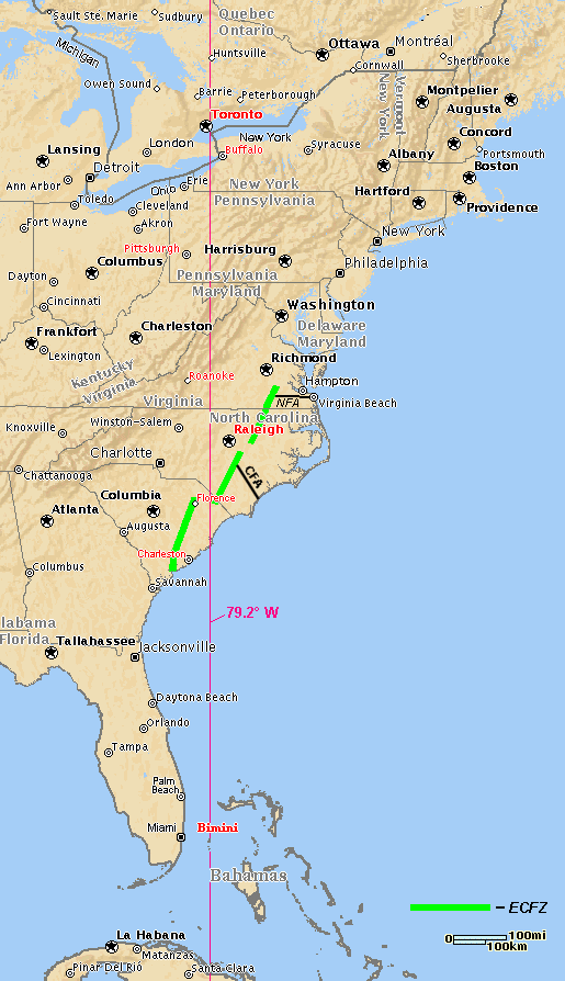 Fig 6. Map of eastern North America showing the 79.2°W meridian, the East Coast Fault Zone (ECFZ) segments, and the Cape Fear (CFA) and Norfolk (NFA) arches.
 In 1927, a man interested in developing a resort at Bimini asked the sleeping Cayce:
Q) Is this the continent known as Alta or Poseidia?
A) A temple of the Poseidians was in a portion of this land.
996-12, March 2, 1927
And in 1935, a woman asked about developing a well that she had visited on east Bimini:
As to how, this should be considered seriously from many varied angles that exist. For, as understood, there are those conditions as related to the varied powers that are in power or in affluence as respecting activities of any nature there. And as they exist in the present there are some complications for agreements, contracts, the lettings of this, that or the other.
But this should NOT be left alone; it should be considered from many angles.
Also aid may be induced from the varied societies that have been formed for the study of geological and archaeological activities, or such. For much will be found.
And, as may be known, when the changes begin, these portions will rise among the first. [Emphasis added].
587-4; July 1, 1935
Since the Bimini area will be rising "among the first" - due to the change in the geoid and draining of the Great Bahama Bank as the pole shifts - it should soon be relatively easy to locate any temple remains that may exist "in a portion of this land" (the northwest Great Bahama Bank). But do these remains lie under water less than 950 ft deep today, the amount that Bimini is supposed to be elevated post-shift? My guess is "yes."
Proceeding northward along the shift meridian from Bimini to Charleston, Florence, and Raleigh-Durham, we see (Fig. 6) that the meridian bisects the East Coast Fault Zone (ECFZ), which lies buried beneath the Coastal Plain sediments. In 1943, the following reading was given for a Navy man who wanted to find out if Norfolk, VA, would be a safe place to develop a home.
It's a mighty good place, and a safe place when turmoils are to arise; though it may appear that it may be in the line of those areas to rise, while many a higher land will sink. This is a good area to stick to.
2746-2; November 11, 1943
As mentioned in "In Line of Those Areas To Rise..." (Effects of the East Coast Fault Zone)
"the eastern United States has been experiencing east-west compressional deformation for perhaps the last million years. In response to this compression, crustal rocks buried beneath the Coastal Plain sediments are undergoing local vertical uplifts along the trend of the ECFZ. This has been going on for at least the last 130 thousand years. Current uplift rates along the ECFZ are estimated to be slow (0.02 to 0.3 mm/yr). The fastest rates of uplift are in the southern segment and the slowest in the northern.
"Regional uplift associated with the Cape Fear and Norfolk arches terminates to the west against the East Coast Fault Zone. Initiation of faulting along the ECFZ, perhaps a million years ago, 'decoupled the upper crust west of the ECFZ from the crust to the east.' Consequently, regional uplift was terminated to the west against the fault system..."
And if pole shift were to begin suddenly,
"mildly accelerated compression could produce uplift along the ECFZ. In agreement with the present trend in uplift rates, the greatest uplift would begin in the southern segment of the ECFZ, with lesser rates of uplift occurring as one moved northward. If so, a person living in Norfolk might conclude that his hometown could be "in the line of those areas to rise."
According to Strain (p. 55), compressive forces in Earth's crust can be expected in negative quadrants. Regional subsidence, due to a lowering of magma below the semi-rigid crust, can result in the formation of folded strata. Folding results when a block of the crust sags and the continued horizontal compressive forces cause the crust to increase buckling. As just mentioned, horizontal compression is occurring along the ECFZ today. It might well be expected to accelerate in response to the pole shift under consideration, thus revealing the truth of the statements in the reading about Norfolk appearing to be in the line of those areas to rise.
South America Due For Severe Earthquakes
Following the pole's shift to 89°N, 79.2°W, a positive quadrant will be found lying to the south of the negative North American quadrant. It will manifest south of the equator over South America all the way to and including the Palmer Peninsula and Marie Byrd Land regions of West Antarctica. This positive quadrant will be centered at 45.5°S and 79.2°W, near southernmost Argentina. Much flooding can be expected to occur in southern Argentina. This seems to contradict reading 3976-15, which speaks of the appearance of land "in the Antarctic off of Tierra del Fuego" [Cape Horn]. As explained later, however, West Antarctica is currently undergoing rapid uplift.
South of Quito, on the post-shift equator, all of South America lies in a positive quadrant.
Moving southward from the equator down along the 79.2°W shift meridian we see that it runs just west of Quito, Ecuador, and Lima, Peru, and then continues southward in the Pacific, along a line up to about six degrees of longitude west of the coast of Chile. This means that the geoid has risen everywhere in South America south of the equator and flooding there becomes progressively worse until latitude 44.5°S is reached. Remember this part of reading 3976-15?
South America shall be shaken from the uppermost portion to the end, and in the Antarctic off of Tierra Del Fuego LAND, and a strait with rushing waters.
Regional uplift may be strong in the vicinity of the shift meridian in a positive quadrant. This is due to pressure on the crust from below as liquid magma seeks to obey the imperative of the higher, post-pole-shift geoid (Strain, p. 40). Sea level rises quickly in a positive quadrant during a pole shift. Indeed, we may expect tsunamis frequently to cross the oceans, especially if the pole moves in fits and starts to its final resting place. Christ said,6 in the Bible under the heading "Signs of the End of the Age:"
"There will be signs in the sun, moon, and stars. On the Earth, nations will be in anguish and perplexity at the roaring and tossing of the sea."
Tsunamis cause the sea to begin "tossing" when they mound up over the shallow continental shelf as they move toward shore. They often cause "roaring" when they begin to overtop the coastline itself.
Viscous magma rises much more slowly than sea level when a pole shift moves a region into a positive quadrant In the Andes, rising magma, or rising plastic rock of the uppermost mantle, could lead to numerous powerful earthquakes as the mountains are stretched over the elevated hot rock beneath. Thus can one explain the shaking of South America "from the uppermost portion to the end."
The appearance of land off Tierra del Fuego may again be explained as due to regional uplift in the vicinity of the shift meridian, a region close to the peak line of flooding in this positive quadrant. Elevation of the geoid results also in upward magma pressure at the base of the crust, pushing up the sea-floor surface until it may in some places rise above the water.
ARCHANGEL HALALIEL'S PREDICTIONS
Pole Shift Precursors: Polar Upheavals And
Torrid-Area Volcanic Eruptions
Of all of Edgar Cayce's psychic readings, few have caused as much controversy as number 3976-15. The worldwide occurrence and severity of the Earth changes described in this reading are too much for some to accept. A few people have felt that the predictions in the reading were all to happen in 1934, and that they failed to occur as predicted. This conclusion is based on the interpretation of just two words in the reading. Yet others have felt that correlation of the Earth changes described in 3976-15 with other end-time prophecies actually lend credibility to those given through Cayce. Yes, the reading is a discourse given through Edgar Cayce, by an entity of the spirit world. Here's what happened.
On the morning of January 19, 1934, Cayce gave a reading at the home of Mr. and Mrs. T. Mitchell Hastings, on Park Avenue in New York City. Hugh Lynn Cayce conducted the reading. Gladys Davis acted as stenographer. A Josephine Macsherry was also present. Mrs. Hastings led the group in meditation before Edgar entered his sleep state. Hugh Lynn then began, "We seek at this time such information as will be of value and interest to those present regarding the spiritual, mental, and physical changes which are coming to Earth. You will tell us what part we may play in meeting and helping others to understand these changes."
As I interpret the reading, Hugh Lynn's "you" turned out to be an archangel named Halaliel. For toward the middle of the reading -- and after describing most of the spectacular Earth changes found therein -- he reveals himself with the words, "I Halaliel, have spoken". (Occasionally, messages came through Cayce from specific entities in the spirit realm but, except for 3976-15, never was an entire reading credited to a single spirit entity).
According to other readings, Halaliel is "one who from the beginning has been a leader of the heavenly host, who has defied Ariel, who has made the ways that have been heavy -- but as the means for the understanding." (254-83). [Ariel] was "a companion of Lucifer or Satan, and one that made for the disputing of the influences in the experiences of Adam in the Garden." (262-57). This Halaliel is "not the Christ, but His messenger, with the Christ from the beginning, and is to other worlds what the Christ is to this Earth." (262-71)
And it is Halaliel who said through Cayce, on that wintry New York day in 1934, that:
As to the changes physical again: The Earth will be broken up in the western portion of America. The greater portion of Japan must go into the sea. The upper portion of Europe will be changed as in the twinkling of an eye. Land will appear off the east coast of America. There will be upheavals in the Arctic and in the Antarctic that will make for eruptions of volcanoes in the torrid areas, and there will be shifting then of the poles -- so that where there has been those of a frigid or the semitropical will become the more tropical, and moss and fern will grow. And these will be proclaimed as the periods when his light will be seen again in the clouds. As to times, as to seasons, as to places, ALONE is it given to those who have named the name -- and who bear the mark of His calling and His election in their bodies. To them it shall be given.
3976-15; January 19, 1934
We have already dealt with two of Halaliel's above predictions. Let's turn now to the upheavals "in the Arctic and in the Antarctic that will make for eruptions of volcanoes in the torrid areas, and there will be shifting then of the poles -- so that where there has been those of a frigid or the semitropical will become the more tropical, and moss and fern will grow."
Refer now to Fig. 3, showing a diagrammatic cross-section of the ellipsoidal Earth. The shift meridian in the western hemisphere (left half of figure) is 79.2°W. In the eastern hemisphere it is the 100.8°E meridian. Assume that an incipient mantle slip (MS) down the 100.8°E meridian is being driven to accelerate by unspecified redistributions of mass in the interior of the Earth. This will tend to lead in kind to an acceleration of the existing pole drift down the 79°W meridian. Imagine now an area of Earth's crust in the vicinity of 85°N and straddling the 100.8°E shift meridian. (This area could be represented by a short line on the Earth's surface to the right of the present north pole, FN, on the diagram). This crustal area will be under growing pressure to begin to move into what will become the positive "shift" quadrant NN-W-FN-NE-X. Recall that the positive shift quadrant is away from the pole-shift direction and becomes, post-shift, a quadrant where centrifugal forces have increased. Sea levels are higher, and plastic or molten rock beneath tends to rise as well, although more slowly than the sea.
What can we expect to happen to this area if it is undergoing incipient movement into a positive quadrant? As explained by Strain's dynamic-axis hypothesis (p. 40), when the crust "is stretched over the higher magma seas of the positive quadrants, the crust's poor strength facilitates magma intrusions."7 Such intrusions are common in extensional geologic environments. Crustal extension may lead normal faulting of broken-up crustal blocks, to huge intrusions of magma, or to small-scale dikes and sills. Volcanoes are also produced in extensional environments. Lets look at a telling recent example of possible incipient pole-shift activity from the high arctic, in our hypothetical area straddling the 100.8°E shift meridian.
Beginning in October 1998, a swarm of earthquakes began to be recorded on distant seismographs. This "seismic swarm" originated from the submerged, Gakkel Ridge, north of Severnaya Zemlya, Russia. C. Müller and W. Jokat (2000, EOS, v.81, no. 24) interpreted this swarm, saying that "these events clearly show extensional focal mechanisms characterized by normal-faulting patterns..." [emphasis added]. The seismic-swarm activity lasted an unusually long seven months, and epicenters of quakes were distributed over a distance from 86.4°N, 70°E to 84.4°N, 106.0 °E. The densest part of the cluster was centered at 85.5°N and 87.0°E. The seismological data were further interpreted to be emblematic of "cone-shaped [volcano] caldera-collapse events." They continue by saying that "most earthquake swarms occur in volcanic regions, and their occurrence is often related to the movement of magma." Thus, all of the criteria for an upheaval in the arctic, as associated with incipient, pole-shift induced movement of the crust toward a positive quadrant, have been satisfied. The crustal behavior under extension - resulting in block faulting, magma movement, and volcanism - has been met. The authors conclude that the earthquake swarm "is the first direct evidence of recent volcanic activity in the high Arctic," and state that "in March 2000, the Hawaii Mapping Research Group reported the "on the sea floor there.
This historically-unprecedented seismic and volcanic activity, occurring as it has in the very recent past, seems to correlate well with the prediction by Halaliel (3976-15) to the effect that "there will be upheavals in the Arctic and Antarctic... and there will be shifting then of the poles..." The time of the shifting of the poles is given in reading 826-8 as 2000-2001. Thus, with the above-reported arctic volcanism suggesting that pole shift may be in the process of beginning, the Earth may have only a few months left before the shift itself becomes obvious and Earth changes begin in
How Can The Upper Portion of Europe Be Changed In The Twinkling Of an Eye?
Continuing with reading 3976-15, we find this startling sentence:
The upper portion of Europe will be changed as in the twinkling of an eye.
The upper portion of Europe probably includes northern Norway, Sweden, Finland, and perhaps Russia as far east as Archangel. Its southern boundary might be around the 64°N, or about 2-1/2 degrees latitude south of the Arctic Circle. This land mass is probably close enough to the arctic region to be affected by "upheavals in the Arctic," of the type discussed above.
The neutral shift meridian (10.8°E) runs roughly through Oslo, Norway. Here, the 10.8°E meridian divides the negative North-American post-shift quadrant from the positive northern-Asia post-shift quadrant. Because the neutral shift meridian runs just to the west of the land designated in the reading as "the upper portion of Europe," all of this land will lie in the same positive post-shift quadrant that was discussed just above. Because of the suddenness of the change for northern Europe mentioned in the reading, and owing to the fact that the first thing that occurs during a pole shift is a change in sea-level and a related redistribution of areas of land and sea, we may reasonably speculate that - initially -- former land elevations will decrease as the positive quadrant is flooded. This will affect the lowlands of northern Norway (including possibly Spitsbergen), Sweden, Finland, and Russia in Europe.
How Can Polar Upheavals Cause Torrid-Area Volcanic Eruptions?
Earth's torrid areas lie roughly between the Tropics of Cancer and Capricorn, or approximately latitudes 23.5°N and 23.5°S of the equator, respectively. Once again, Halaliel's message, as channeled through Cayce in reading 3976-15 says:
There will be the upheavals in the arctic and antarctic that will make for the eruption of volcanoes in the torrid areas, and there will be the shifting then of the poles...
Stated clearly here is the proposition that eruptions of volcanoes in the torrid areas can be induced by crustal upheavals in the arctic and antarctic. This seems to imply that upheavals in the polar regions must be of sufficient magnitude to start to unbalance the rotating Earth and induce the poles to attemptto shift. Such activity will cause those volcanoes located to either side of the equatorial bulge in the torrid areas to respond to the incipient pole shift.
Any attempt of the overlying mantle and crust to move over or away from the equatorial bulge will cause sufficient disturbance to cause magma to rise into many of the torrid-area volcanoes. Volcanoes closest to the eventual shift meridian could be expected to be the most eruptive. The idea here is that as a region of the crust and mantle straddling the incipient shift meridian tries to move toward the equator, it must cover a somewhat larger area (or, in three-dimensions, fill a greater volume). But there is insufficient material available to do so. On the other hand, any torrid-area mass trying to move away from the equator is subjected to contraction, as there is an excess of material available.
In regions of existing torrid-area volcanism, such disturbances of the crust and mantle related to pole shift would be sufficient to facilitate magma flows. Such magma flows would very often lead to eruptions through paths of least resistance in the crust. These would be paths through incipient fractures and existing volcanoes. Old fractures could be reactivated allowing magma to move through them.
Some of the best work on shift of the mantle and crust over the equatorial bulge was done by J. Campbell for C. Hapgood's book entitled, The Path of the Pole (1970, Chilton Book Co., New York). For example, consider Figure 7 below, adapted from Fig. 34 in Hapgood's book. The figure shows diagrammatically the pattern of faulting and folding during displacement of the crust and mantle. Only one meridional fault (the shift meridian) is shown, which is moving toward the equator in the northern hemisphere. The dotted lines indicate other faults opening from the bottom of the crust as the arc of the surface diminishes. Across the equator, where the crust is moving toward the pole, and compression is resulting, the continuation of the major expansion fault is shown as a pressure ridge. Dashed and solid vertical lines designate other crustal fractures that may be expected to parallel the major meridional fracture.
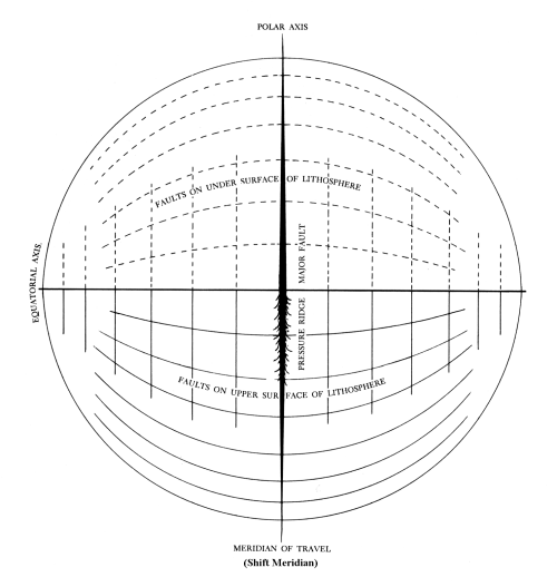 FIGURE 7 - Fractures resulting from movement of the mantle and crust over the equatorial bulge.
Now we are only talking about the incipient motion of the mantle and crust over the equatorial bulge. Magma can follow paths through fractures under stress; fractures that are trying to begin to open fully from the bottom of the lithosphere in the quadrant moving toward the equator, and through fractures trying to open fully through the top of the lithosphere. Pre-existing volcanoes that are already magma conduits will tend to erupt first.
For our hypothesized shift meridian of 79.2°W and 100.8°E, the most eruptive volcanoes will be those in a broad torrid-area region from Indonesia and the Andaman Islands, eastward to the Philippines, New Guinea, and the Bismark Archipelago. In the western Hemisphere, the most sensitive and eruptive volcanoes will be those extending from southern Mexico, central America, and the Caribbean Leeward Islands, to the Galapagos Islands, Columbia, Ecuador, Peru, Bolivia, and northernmost Chile and Argentina in South America. The subset of volcanoes that will erupt most vigorously will tend to be those closest to the equator in the torrid areas, as well as those nearest to the shift meridian. Thus, the volcanoes of Indonesia and Ecuador (includes Galapagos Islands) are the centers of the most dangerous volcano regions in their respective hemispheres.
The Toba caldera in Sumatra, Indonesia, is the site of what may be the world's largest super-volcano. Super-volcanoes lie above huge magma reservoirs and their magma is full of trapped dissolved gases like carbon dioxide or sulfur dioxide. Intense eruptions occur when the trapped gases break out of confinement during an eruption and blast the frothy magma to high altitudes. Around 74,000 years ago, Toba erupted catastrophically, releasing an estimated 1,735 cubic miles of sulfur-charged magma (mostly as ash) to great heights. This eruption reduced world temperatures 5° to 10° C for several years.
Toba is located at 2.6°N, 98.8°E, or about 105 miles west of the shift meridian and 200 miles north of the equator. It seems to be a prime candidate to wreak havoc once again when "the upheavals in the arctic and in the antarctic…make for the eruption of volcanoes in the torrid areas." Masturyono, And Others (2001, Geochem. Geophys. Geosys., v.2) conducted a geophysical survey across Toba to image its internal structure. They identified areas where magma is present down to mantle depths. The largest magma body underlies about one half of the caldera. Melts in the mantle are providing the heat for crustal melting that forms large explosive reservoirs. We speculate that as the incipient mantle slip tries to bring Toba 1° closer to the equator, the crust will begin to stretch and centrifugal forces will begin to increase. A large eruption might then ensue.
Before leaving Figure 7, consider an incidental observation. Recall the reading that says:
If there are the greater activities in the Vesuvius, or Pelée, then the southern coast of California - and the areas between Salt Lake and the southern portions of Nevada - may expect, within the three months following same, an inundation by the earthquakes.
270-35; January 21, 1936
Now it just so happens that the southern coast of California and the areas between Salt Lake and the southern portions of Nevada all lie on the same great circle with Vesuvius. And that great circle seems very similar to one of the upper hemisphere great circles presented on Figure 7.The meridian that is perpendicular to the great circle in question is the 48°W meridian. Question: could the 48°W meridian be an old shift meridian for a previous pole shift? And could the great circle linking southern California and Vesuvius coincide with an old fracture whose weakness might be reactivated in various locations as the pole tries to begin to shift this year? Have we identified a weak doomsday fracture that will respond sensitively to the imperative of the stresses and strains of an upcoming pole shift?
Now we'll move on to consider additional evidence for the upheavals in the arctic and antarctic mentioned by Halaliel as causing increased torrid-area volcanism just prior to pole shift. In Coming Earth Changes (p. 39), I mentioned the outstanding study8 that T. James and E. Ivins had made of present-day antarctic ice-mass changes, associated crustal uplift, and their effect on polar motion. In their paper reporting their study they said:
If Antarctic deglaciation history portrayed in the ICE-3G crustal rebound model is realistic...., then a vast geographical region in West Antarctica is uplifting at a rate in excess of 20 mm/yr, and the predicted changes in polar motion are quite substantial. [Edited composite of quotes from the paper].
Updates to the latest crustal-rebound model (ICE-4G) have been made since 1995. They show predicted uplift rates that are somewhat smaller than those first given for crustal upheavals due to the slowly melting Antarctic ice sheet. But according to James, "the newly computed uplift rates are still quite substantial" (1997, personal communication). This broad-scale uplift of the crust in West Antarctica may turn out to be of great importance with respect to inducement of a sudden pole shift.9
Return now to the arctic. Although puny with respect to the broad-scale antarctic crustal uplift mentioned just above, there is evidence for an upheaval in the southern Arctic. It is found in an abstract [AGU Annual Meeting, no. T22A-17, 2000] by F. Sigmundsson entitled, 1994-2000 Volcanic and Seismic Unrest at a 200-km-long Stretch of the Mid-Atlantic Ridge Plate Boundary in Iceland: Episodic Magma Delivery," We read that after a quiet period during the middle part of the 20th century, volcanic and earthquake activity began to increase. In south and central Iceland, activity has been unusually high since 1994. "Magma accumulation and intrusion has taken place beneath two...volcanoes: Hengill volcanic area, and Eyjafallajökull. In both cases uplift [emphasis added] is confirmed by geodetic measurements and earthquake activity has been unusually high...(two tectonic earthquakes of "
Finally, in a September, 1997, paper in EOS (v. 78, no. 35), entitled "Center of the Iceland Hotspot Experiences Volcanic Unrest," we are reminded that the volcanoes of Iceland, located near the Arctic Circle, can "produce catastrophic events of global importance....[and]....there is every reason to worry when they become restless. Simply put, a plume of deep mantle material may be getting ready to erupt extensively in Iceland." Such plume-eruption activity may or may not rate as an upheaval, but one is tempted to think that it does.
The Break Up Of Western America
Near the middle of reading 3976-15, Halaliel begins to respond to Hugh Lynn's instructions to sleeping Cayce, which asked for a forecast "regarding the spiritual, mental, and physical changes which are coming to the Earth." The answer begins:
As to the changes physical again: The earth will be broken up in the western portion of America.
From a geologist's perspective, the western portion of America that would be broken up includes practically all land west of the boundary between the Great Plains and the Rocky Mountains, from north-central New Mexico north through Colorado, Wyoming, and Montana. (South of central New Mexico, this boundary is between the Great Plains and the Rio Grande Rift).
M. Strain is the first to explain how a small pole shift can cause crustal subsidence in a negative quadrant of the Earth into which the pole moves. This quadrant is one of two antipodal quadrants. Strain's "dynamic axis theory" states that, for a non-rigid crust, "reduced magma pressure in the negative quadrants generates compressive forces since a shortened crust must span the lower magma seas" [and] "synclines, anticlines, subduction zones, and overthrust belts are characteristic of the geologic phenomena associated with decreased magma pressure in the negative quadrants."
Strain's use of the term "magma seas" is unconventional. He says that it "refers to Earth's interior below the lithosphere that can be remolded without fracturing." Accepting this usage, it's clear that the thinner the lithosphere and the hotter (more easily remoldable) the underlying plastic rock beneath, the quicker will the crust react to compressive forces generated during and after pole shift into a negative quadrant. It turns out that this is in fact the situation throughout most of Western North America. Please refer now to Figure8.
Quoting from Coming Earth Changes (p. 257),
R. A. Kerr, in a recent review article in Science (March 14, 1997, p. 1564), says, "New geophysical research shows that the lofty peaks and plateaus of the American West are buoyed up not by the continental crust alone, but also by deeper forces from Earth's mantle." He goes on to state that the West, floating on hot buoyant mantle beneath, is slowly spreading outward. Because it is hemmed in on most sides by rigid lithospheric plates, it may slowly "be heading for the Pacific Northwest, where plate motions open a small escape hatch."
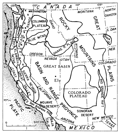
Recent geophysical measurements that permit analysis of slowly changing distances between points on the surface show that the Colorado Plateau is hardly moving. But at Ely (Fig. 8), in eastern Nevada, the land is moving westward across the Basin and Range Province, "sliding from the heights supported by the hot, buoyant mantle," according to Kerr's review. In Utah, the "areas between Salt Lake and the southern portions of Nevada" lie roughly along the boundary between the Colorado Plateau and the Basin and Range Province. This boundary now appears to be a zone of crustal extension and, if suddenly subjected to accelerated mantle motions, the crust there could experience catastrophic earthquakes and faulting. But such a surmise is exactly opposite to the fate that would be predicted from analysis of this article's small pole shift down the 79.2°W meridian into a negative quadrant.
According to Kerr's review of this new model of the mantle and crust of the American West, the push of land sliding westward from the heights across Nevada's Basin and Range is pushing the crust into the Sierra Nevada and "crunching up the crust along the San Andreas [fault]." That's the reverse of the conventional view, which holds that it's the Pacific Plate pushing eastward that shoves up the Coast Ranges (Fig. 8) along the length of California. And both views differ from what we think will happen if and when our small pole shift brings all of North America into a negative quadrant.
If the pole shift brings North America into a negative quadrant, the buoyant hot mantle currently underlying so much of the American West will relatively quickly begin to lower, to agree with the progressively-lowering geoid. The crust overlying the mantle will then undergo compression as it too is lowered. The magnitude and speed of this readjustment will affect the severity of crustal fracturing and break-up. And it will also determine the frequency and strength of earthquakes associated with any failures of the crust as it sinks to rest on the lowered substratum of hot, plastic rock. Thus, areas of local subsidence may appear.
Strain thinks that, "Any over-correcting by the crust, as it collapses or is driven down into the magma interior like a hydraulic plunger, creates a local increase in magma pressure. This can explain how local positive pressure is creating volcanic activity along negative quadrant crustal features..." An example of such activity may have just recently been reported. Two geologists with the U. S. Geological Survey haveproduced a study entitled, "Large-Scale Geologic Patterns Point To The Birth Of A Hotspot In The Western U. S." This "hotspot" seems to be a regional focus for the breakup of the Oregon-Idaho portion of the American West. Such a hotspot might even be reflecting surrounding crustal lowering due to the first ephemeral pressures on the mantle and crust at the beginning pole shift. J. Glen and P. Ponce write [AGU National Meeting Abstr. T21C-15, 2000], "Numerous ...geologic lineations (including fold axes, dike swarms, and faults) when extrapolated intersect at approximately the same location, suggesting that all these features radiate from a single point - a region near the Idaho-Oregon border at about latitude 44 degrees."
Because local, positive magma pressures can be generated in newly-formed negative quadrants by a variety of crustal compression forces, those magma pressures may in many cases be released by volcanic eruptions. Thus, we may expect considerable volcanic activity in the western U. S. during and after pole shift. Strain outlines a number of crustal collapse features that can lead to volcanism in his book.
Will The Small Pole Shift Be Able To Cause Halaliel's Climate Changes?
The mention of a pole-shift-produced climate change is once again repeated from archangel Halaliel's words:
There will be the upheavals in the Arctic and Antarctic that will make for the eruption of volcanoes in the torrid areas, and there will be the shifting then of the poles - so that where there has been those of a frigid or the semi-tropical ["subtropical" in current usage] will become the more tropical, and moss and fern will grow.
3976-15; January 19, 1934
I'll speculate now upon the strangely worded phrase "a frigid or the semi-tropical will become the more tropical." I think that it simply means that locations straddling the shift meridian where the climate was quite cold will warm up, concomitantly with the subtropical area in the same quadrant becoming more tropical. Look, for example, at the positive quadrant centered at 45.5°N,100.8°E. Taking globe in hand, rotate it toward you, down the 100.8°E shift meridian, to simulate the slip of the crust and mantle shown in Figure 3. As you do so, you can see that Earth's tropical-climate areas on the north side of the equator are moving northward (following the northward displacement of the equator) over lands previously in subtropical climate areas. This will allow tropical ferns to grow in the formerly subtropical areas. As one continues to rotate the globe it's clear also that formerly frigid areas at the north end of 100.8°E begin to experience a slightly warmer climate, to the point that arctic moss may begin to grow on exposed surfaces.
This same sequence of climate changes will occur also in the opposite positive quadrant, and most strongly in those regions in general proximity to the shift meridian. Thus, two of Earth's quadrants will experience Halaliel's climate changes, according to the scenario he specified. These are the Asian and the South American pole-shift quadrants.
But through how many degrees of latitude does one have to rotate the globe before these climatic effects become clearly noticeable? On the 79.2°W side of the shift meridian, a one-degree move of the crust up the shift meridian, in the North American negative quadrant, would induce such a small climate change in Florida that it would only be equivalent to the difference in going from Miami to Palm Beach, Florida. (See Fig. 6).
A pole shift of just one degree thus seems insufficient to realize Halaliel's climate-change scenario. How many degrees are necessary then - two, four,...ten? Just how much of a pole shift was Halaliel trying to communicate here? Perhaps he saw a shift that was small, but one just sufficient to make any climatic-change features noticeable. This might be possible in places where there are strong changes in climate types over short distances. For such locales, a sudden change in latitude of 1° could make noticeable differences in vegetation.
What is disturbing about all this is what happens if we start entertaining larger pole shifts, to make Halaliel's climate changes more noticeable. For example, assuming a rigid crust, a three-degree pole shift to 87°N, 79.2°E would cause the land surface in the Miami-Bimini area to rise to +2,853 ft relative to the new sea-level geoid. This higher crustal elevation would effectively block the flow of the Gulf Stream through the Florida Straits and cause the climate of Europe to become much colder than present. (Of course, such a result could also fulfill Halaliel's prediction that, "The upper portion of Europe will be changed as in the twinkling of an eye"). Clearly, we must be open to considering pole shifts larger than 1 ° as we attempt to define the nature and results of the shift to come. But a pole shift of 5 or 10 degrees seems far too much at this stage of our understanding.
What Is Underlying Cause of The Imminent Pole Shift?
There is a mention of a possible relationship between extraterrestrial forces and the predicted pole shift in 2000-2001 , as inferred from two Cayce readings.
Q Will Italy adopt a more liberal form of government in the near future?
A Rather that of a more monarchical government than that of the liberal. Italy, too, will be broken by what NOW is an insignificant or small power [known to us today as Germany] that lies BETWEEN those of the other LARGER, or those of the MOMENT that are of the larger. These will not come, as we find, as broken, before the catastrophes of outside forces to the earth in '36, which will come from the shifting of the equilibrium of the earth itself in space, with those of the consequential effects upon the various portions of the country --or world--affected by same. (Emphasis added).
3976-10; February 8, 1932
Q. What will be the type and extent of the upheavals in '36?
A. The wars, the upheavals in the interior of the Earth, and the shifting of same by the differentiation in the axis as respecting the positions from the Polaris center."
5748-6; July 1, 1932
It's possible that the "catastrophe of outside forces" might, physically speaking, reflect a particular configuration of astronomical bodies (1602-3). And the "differentiation in the axis" in 1936 could refer to either a subtle shift of the whole-Earth rotational axis or to a shift of the rotational axis of the independently spinning core. The latter possibility seems best to reflect the words "the shifting of same", because these words seem clearly to refer back to "the interior of the Earth."
If there is anything to the upcoming pole shift predicted in Cayce's readings, I think it will most likely have been caused, initially, by the production of instabilities near the core-mantle boundary in 1936. Such instabilities could have changed mass distributions in the lowermost mantle sufficient to induce - after a lag in time -- a sudden shift in the poles via mantle slip. See our Gravity of Inner Earth Upheavals article for the latest on mass distributions at the core-mantle boundary and their great importance to crustal movements at Earth's surface.
As inferred from the readings, a roughly 65-year time lag is involved from the time of the catastrophe of outside forces (in 1936) to the present (2001) to engender the predicted pole shift. In terms of geological processes, this seems to be far too little time, unless the dense core fluid reacted extremely quickly to the catastrophe of outside forces. But then, there are so many possibilities to consider when speculating about processes in the interior of the Earth that we might just as well leave the whole pole-shift business to our intuition.
As a matter of fact, that's where this article began - with the psychic intuition of Edgar Cayce. Our own intellectual processes pale beside the blazing Earth-change revelations of Archangel Halaliel and others who sought to counsel us creatures through Cayce's mental apparatus. With just a few months to go before the end of the pole-shift window of 2000-2001, we will soon find out whether or not the readings' predictions are correct.
THE HUTTON COMMENTARIES' YEAR 2001
POLE-SHIFT AND EARTH-CHANGES SCENARIO
Assumptions
"Examine your assumptions. Then examine the assumptions behind your assumptions."
--- Saying
The principal assumptions underlying the scenario below are eight in number:
-
As per the predictions in three Cayce readings, Earth's poles will shift, either close to the present time (readings 3976-15, and 378-16), or this very year, 2001 (826-8).
-
The north pole will begin to shift in the same direction that it traveled throughout the last century.
-
The method of pole shift will involve slip of the mantle over Earth's outer core.
-
Each of the poles will shift a total distance of around one degree.
-
The procedures used for calculating the effects of the pole shift on planetary centrifugal forces and sea levels are valid approximations to the true ones.
-
The procedures used to calculate post-shift changes in elevation of specific points on Earth's surface are correct to within about ±5 percent of the true values.
-
The generalized Earth changes expected according to the positive- and negative-quadrant approach to tectonic assessment are correct.
-
The Earth-change predictions given in the Cayce readings will occur in response to the upcoming pole shift.
The Major Assumption Behind The Assumptions
Pertaining To Cayce's Readings
The Edgar Cayce readings on pole shift and Earth changes exemplify those forms of intuition-based knowledge that go back to ancient times. Such times were those when humankind could apprehend levels of meaning in the universe via symbols. And they were times when people could communicate with the soul minds of higher masters, listen to "angels" and "archangels," or probe the akashic records and the universal cosmic consciousness.
We must now ask, are Cayce's Earth-change readings about to be realized, pushing us into an age that will allow us once again to use kinds of knowledge born of intuition and the brain's multiple non-verbal talents? Or will the pole-shift and Earth change readings not be realized - because they were hopelessly wrong, or simply misunderstood because they were too symbolic for us to interpret properly?
It is known that Mr. Cayce himself had concerns about the validity of the Earth-change readings he'd given. On the night of March 3, 1936, he had the following dream aboard a train returning to Virginia Beach from Detroit. This dream was interpreted for Cayce in a reading he gave for himself four months later. I'll quote now from the CD-ROM records that contain the relevant Cayce reading.
Q Interpret and explain the dream which Edgar Cayce had on March 3, 1936, in which he was born again over two hundred years in the future and traveled to various sections of this country where records of Edgar Cayce could be found.
[Detailed dream not read:]
[3/3/36 On train from Detroit to Va. Beach, following end of court action in re his arrest in 11/35 for "practicing medicine without a license". See 254-89 Reports of Court Trial.]:
I had been born again in 2158 A.D. in Nebraska. The sea apparently covered all of the western part of the country, as the city where I lived was on the coast. The family name was a strange one. At an early age as a child I declared myself to be Edgar Cayce who had lived 200 yrs. before. Scientists, men with long beards, little hair, and thick glasses, were called in to observe me. They decided to visit the places where I said I had been born, lived and worked, in Ky., Ala., N.Y., Mich., and Va. Taking me with them the group of scientists visited these places in a long, cigar-shaped, metal flying ship which moved at high speed. Water covered part of Ala. Norfolk, Va. had become an immense seaport. N.Y. had been destroyed either by war or an earthquake and was being rebuilt. Industries were scattered over the countryside. Most of the houses were of glass.
Many records of my work as Edgar Cayce were discovered and collected. The group ret'd to Nebraska taking the records with them to study.
A These experiences, as has oft been indicated, come to the body in those manners in which there may be help, strength, for periods when doubt or fear may have arisen. As in this experience, there were about the entity those influences which appeared to make for such a record of confusion as to appear to the material or mental-minded as a doubting or fearing of those sources that made for the periods through which the entity was passing in that particular period.
And the vision was that there might be strength, there might be an understanding that though the moment may appear as dark, though there may be periods of the misinterpreting of purposes, even THESE will be turned into that which will be the very proof itself in the experiences of the entity and those whom the entity might, whom the entity would in its experience through the earth plane, help; and those to whom the entity might give hope and understanding.
This then is the interpretation. As has been given, 'Fear not.' Keep the faith; for those that be with thee are greater than those that would hinder. Though the very heavens fall, THOUGH THE EARTH SHALL BE CHANGED, though the heavens shall pass, the promises in Him are sure and will stand - as in that day - as the proof of thy activity in the lives and hearts of those of thy fellow man.
For indeed and in truth ye know, "As ye do it unto thy fellow man, ye do it unto thy God, to thyself." For, SELF effaced, God may indeed glorify thee and make thee STAND as one that is called for a purpose in the dealings, the relationships with thy fellow man.
Be not unmindful that He is nigh unto thee in every trial, in every temptation, and hath not willed that thou shouldest perish.
Make thy will then one with His. Be not afraid.
That is the interpretation. That the periods from the material angle as visioned are to come to pass matters not to the soul, but do thy duty TODAY! TOMORROW will care for itself.
These changes in the earth will come to pass, FOR THE TIME AND TIMES AND HALF TIMES ARE AT AN END, and there begin those periods for the readjustments. For how hath He given? "The righteous shall inherit the earth."
HAST THOU, MY BRETHREN, A HERITAGE IN THE EARTH?
294-185; 6/30/1936
We're not the first to be confused by the words that begin the second paragraph from the end of the above quote. To what changes does the pronoun these refer? The changes in the Earth mentioned in the quote itself, or the changes in the Earth given in Cayce's readings? Various students of the readings believe one or the other, or even both! I think that these refers to the Earth changes predicted in Cayce's previous readings. It was those predicted changes that were bothering him, not the symbolic Earth changes given in his dream.
At any rate, those of us who are confused about whether the Earth changes will come to pass are now in the same shoes that Cayce was in when he had his dream. Sometimes we think that pole shift and Earth changes will surely take place. At other times we think the whole subject is somewhat absurd. A certain way to arrive a decision seems to be to give the process time to work; that is, have patience, watch, and do one's duty to others while waiting. My assumption, however, is that the Earth changes will take place, and soon!
The Scenario
Imagine that we have been transported in time to 2201 A.D. We are attending a lecture by a geologist who is reporting on the pole-shift and Earth-change events that took place 200 years earlier. Here are the principal events that he says occurred in those days. [Note that the lecturer has no problem mixing what we recognize as the Cayce predictions with factual data collected by the scientific community of the 23rd century.]
-
A "catastrophe of outside forces" affected the Earth in 1936.
-
The outside forces engendered upheavals in the interior of the Earth that caused the rotational axis, presumably of the independently spinning core, to shift slightly.
-
Over the next 65 years, there developed a sufficiently-changed distribution of masses at the core-mantle boundary, and (or) in Earth's lower mantle, to prime the Earth's upper layers for a slip of the mantle and crust over the fluid outer core.
-
Toward the end of this 65-year period, mantle/crustal "upheavals" began to be observed in the high arctic and, especially, over West Antarctica.
-
These upheavals had been continuing for perhaps thousands of years. They had the effect of augmenting polar-eccentric crustal masses, and these masses began to act as a trigger to initiate pole shift.
-
As the polar trigger-mechanism slowly expressed itself, sensitive volcanoes in Earth's torrid areas began to erupt, reflecting the pressure build-up that was beginning to start the crust and mantle slipping over the equatorial bulge of Earth's outer core.
-
The 79.2°W meridian became the pole-shift meridian, because for roughly the prior century, the north pole had been moving down this meridian toward Toronto, Ontario.
-
As Earth's mantle and crust slipped over the core, down the 100.8°E part of the shift meridian, the north and south poles and Earth's equator all moved in the opposite direction; that is, the piercing points of the Earth's independently spinning axis of rotation seemed to move, in response to the actual slip of the crust and mantle in the opposite direction.
-
The initial manifestations of the shifting poles involved lowering of sea levels and draining of former lowlands in two of Earth's quadrants. Rising sea levels flooded former land areas in the other two quadrants. All the while, tsunamis and sloshing ocean waters moved back and forth across the ocean basins.
-
Following the sea-level changes, changes in Earth's crust began slowly to take place all over the globe. The greatest crustal rising orfalling took place closest to the shift meridian.10
-
As the poles shifted, the changing centrifugal-force field caused a new distribution of areas of land and sea. The quadrant of Earth's surface centered over North America defined 25 percent of the planet's area in the direction of pole shift. In this quadrant, centrifugal forces were reduced and sea level was lowered. Massive drainage of lowland areas occurred and the continental shelves were exposed along most parts of America's east and west coasts.
-
Opposite to the North American negative quadrant there was another in the Southern Hemisphere. It included Australia, New Zealand, southern Africa, and all of the Indian Ocean. Here again land surfaces became elevated relative to a fallen sea-level geoid.
-
The two positive quadrants, of Asia and South America, were in the direction away from pole shift. There, centrifugal forces were increased and sea levels were raised. Coastlines and lowlands were massively flooded. Later, as fluid magma and plastic mantle beneath the crust began to exert pressure on the crust from below, the crust stretched in extension. This facilitated intrusions of magma, forming everything from underground dikes, sills, and batholiths to aboveground flood basalts and volcanoes in places where none had occurred before.
-
The two negative quadrants of North America, and the Indian Ocean and surrounding lands, were located in the direction of pole shift. There, post-pole-shift centrifugal forces were reduced, sea level was lowered,and continental shelves were exposed. Somewhat later, as fluid magma and plastic mantle beneath Earth's crust began to respond to the changed centrifugal forces, the planet's two negative quadrants began to experience compressive crustal forces due to sinking of the crust as deformable hot rock below was withdrawn. In many places this led to either local or regional subsidence, or yet again, to the crumpling of the crust. Folded rock formations, crustal overthrust belts, ocean trenches, and subduction zones were augmented, or new ones began to form.
How Precise Is The Scenario?
Will the pole shift described above definitely proceed southward on the 79.2°W shift meridian?
No, but we think that it will move down a longitude within roughly 60° to 80°W. We plan further to refine the direction of pole shift to better satisfy the
Will the pole shift be exactly one degree of latitude, stopping precisely at 89.0°N?
Probably not, but we do expect that the shift will be small. We think, based on the above results, that a one-degree shift is about right.
Are you saying, then, that your pole-shift and Earth-changes scenario is basically correct as far as trends are concerned, although specific details may vary depending on local geophysical conditions?
Yes. Here's an example. As predicted by the scenario, changed distributions of land and sea will be realized immediately after pole shift. Continental shelves and lowlands will be drained and exposed in two "negative" quadrants, and flooded and submerged in two "positive" quadrants. This will result from a worldwide alteration in the sea-level geoid due to changes in centrifugal forces brought about by the shift.
Changes in Earth's crust will occur over a period of time due to the imperative of the new centrifugal- force patterns acting on plastic mantle and liquid outer-core materials. Some crustal changes will run counter to those expected. Although one might anticipate uniform exposure of the drained continental shelf off the U.S. Atlantic coast, one might actually find places where the land had sunk relative to the surrounding, newly exposed land. This would be due to pre-existing tendencies favoring sinking over geologic time. Magma and/or plastic mantle underlying a given area of crustal subsidence could also have been lowered (along with sea level), causing the crust above to sink even more rapidly.
Places along the U.S. east coast where this sub-plot could occur would be in areas of long-term subsidence, like the southeast-Georgia, Salisbury, and Raritan embayments (see Fig. 5). Also, relative sinking of pre-existing embayments might well occur at different rates along the Atlantic coast. This would be due to differing site-specific geologic factors and the embayments' proximities to the shift meridian (Fig. 6). Such seems to be implied in reading 1152-11 (August 13, 1941):
Portions of the now east coast of New York, or New York City itself, will in the main disappear. This will be another generation, though, here; while the southern portions of Carolina, Georgia - these will disappear. This will be much sooner.
Continuing Research
We plan next to calibrate our pole-shift results against Earth-changes predicted to occur in the readings. What we're looking for is a shift meridian that will satisfy, simultaneously, three readings-based conditions in separate parts of the world. These conditions require that:
1) the modeled shift results for Japan match with Archangel Halaliel's prediction (3976-15) that, "The greater portion of Japan must go into the sea,"
2) the shallow sea floor off Yucatan be drained and "there will be seen new lands off the Caribbean Sea, and DRY land will appear" (3976-15) so that "the temple by Iltar will rise again" (5750-1) and the records of Atlantis can be found, and
3) the Giza Plateau in Egypt (currently at 19 meters above sea level) will not be flooded, so that the records of Atlantis can be found near the Sphinx.
These are the minimum conditions that must be met for one to have confidence in his specifications for the predicted pole shift.
Footnotes
-
R. Gross and J. Vondrák (1999, Geophys. Research Ltrs., v. 26
-
Kerr, R., 1987, Science, v. 236, p. 147
-
1997, ATL Press, Inc., Shrewsbury, Massachusetts
-
The geoid is an imaginary surface that undulates over Earth's areas of varying gravitational attractions. The direction of gravity is everywhere perpendicular to this surface.
-
R. Gross and J. Vondrák (1999, Geophys. Research Ltrs., v. 26
-
New International Version of the Bible (Luke 21: 25)
-
"Magma seas" is a term coined by Strain. It refers to Earth's interior below the lithosphere that can be remolded without fracturing. (I use "crust" and "lithosphere" interchangeably in this article).
-
Geophys. Res. Letters, v. 22, no. 8, April, 1995.
-
An interesting fact in this regard is that the center of gravity of the antarctic ice sheet is off-center relative to the south pole of Earth's rotation. The center of gravity lies roughly at 85° S and 96°E, or only 4.8° of longitude from the 100.8°E shift meridian we are postulating here. This off-center polar ice mass could be considered of importance as an explanation of any pole-shift "inducing mechanism."
-
The shift meridian in the Western Hemisphere ran southward from the North Pole, across Hudson Bay to near Toronto, then through eastern North America, the Bimini Islands in the northwestern Bahamas, central Cuba, Panama City, and Quito Peru. It then ran offshore of South America at Trujillo, Peru, and ran offshore of South America south to the Palmer Peninsula, West Antarctica, and to the south pole. In the Eastern Hemisphere, the shift meridian ran northward from the south pole across western Wilkes Land in Antarctica, across the eastern Indian Ocean to Padang, Sumatra, then to Bankok, and through China and Mongolia to Tura, Siberia, and then north across Severnaya Zemlya (Russia's "North Land") to the north pole.