
Archived Articles
Earthquake & Volcano Potpourri
Introduction
In 1941, Edgar Cayce was asked, “Will Los Angeles be safe? The answer was
Los Angeles, San Francisco, most all of these will be among [emphasis added] those that will be destroyed, before New York even.
1152-11 August 13, 1941
Sixty years have passed since this reading. Students of the readings have concluded that either this prediction was faulty or that it will come to pass as a result of the tremendous strains produced in Earth's crust by the predicted pole shift. Assuming the latter to be true, reading 1152-11 suggests that all of the west coast of America will be affected. This conclusion requires us to examine the state of strain in the crust due to the regional stresses that may be building there now, even before pole shift, from California to Washington. Our approach will be to consider both recent and ancient earthquakes and patterns, and also the prognostications of earthquake experts for the immediate future. We will then examine the possibilities for earthquakes or volcanic eruptions at a selected few of the other cities relevant to the Cayce Earth-change predictions.
The Southern Puget Sound, Washington, Earthquake, And Earlier Ones
The February 28, 2001, M 6.8 earthquake was a slab earthquake, the most frequent and generally the most benign type of quake in the region. A slab earthquake originates within a tectonic plate, or slab, that is sliding beneath another. The quake originated very close to the location of one of similar magnitude in 1949.
Centered beneath the delta of the Nisqually River between Tacoma and Olympia, the tremor should not be assumed to indicate that the region is off the hook. Geologists note that other types of earthquakes, generated offshore or in shallow faults, will certainly visit the area and will likely be more damaging. Several shallow faults lie beneath Seattle.
The Seattle fault zone is forty miles long and about five miles wide. The zone's huge complex of faults runs roughly east-west under Puget Sound and beneath the southern part of Seattle. Research shows that a bedrock basin lies just north of the fault zone. Sediments that filled this basin have become the building ground for Seattle's many structures. Unfortunately, the material with which the basin is filled strongly amplifies earthquake shaking. The structures and earthquake potential residing in the southern Puget Sound area represent an enormous disaster waiting to happen. This is especially true when one considers that Seattle is about 90-95 miles from the Cascadia subduction zone. Anchorage, at roughly the same distance from the Alaskan subduction zone, was strongly shaken by a giant (M 9.2) quake in 1964.
With regard to past large quakes in the central Puget Sound area, J. Bourgeois and S. Johnson (Geological Society of America Bulletin, v. 113, no. 4), indicate that C14 dates from materials in disturbed channel banks along the lower Snohomish delta in the Puget Lowland show evidence of large earthquakes within intervals between A.D. 800-980, 910-990, 1040-1400, and 1400-1640. They conclude that “in the past 1200 yr, this part of Washington's Puget Lowland has been subjected to stronger ground shaking than in historic times, since about 1870.”
Farther South, in Oregon, the Quake Forecast Shifts to Land
Richard Hill, writing in Washington Geology (September, 2000), says that new research shows that a colossal quake could hit much farther inland under the Oregon Coast Range, and cause severe damage in the cities of the Willamette Valley such as Portland, Salem, and Eugene. This is because the locked zone of the Juan de Fuca and North American plates is larger than previously thought, extending beneath the Coast Range as far as the western side of the Willamette Valley. When the locked zone is finally broken by a huge quake, 300 years or more of accumulated strain will be released. Shaking produced from the predicted magnitude 9 quake would last a terrifying two to three minutes.
Seismicity of California's North Coast
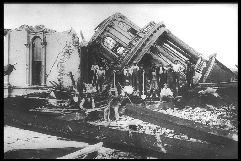
The San Andreas fault zone is the dominant fault system in California. It forms the boundary between the Pacific and North American tectonic plates. At 5:12 a.m., April 18, 1906, the great San Francisco earthquake, measuring Ms 8.2, Mw 7.8, occurred along the northern San Andreas fault segment. [Ms = surface wave magnitude; Mw = moment magnitude. The “moment” is equal to the rigidity of the earth times the average amount of slip on the fault times the amount of fault area that slipped.]
William Bakun, in a paper titled as above (2000, Bull. Seismological Soc. Amer., v. 90, no. 4) reveals his research on the influence of the Mw 7.8, 1906 San Francisco earthquake on the occurrence of M 7 earthquakes along California's north coast in the second half of the nineteenth century. He shows that the 1906 earthquake led to a reduction in the rate of the M 7 earthquakes along California's north coast. Bakun says, “In fact, the nearly 75-year-long relative seismic quiescence after 1906 extended along the entire length of the 1906 rupture, and about 125 km [78 mi] northwest and southeast off the ends of the 1906 rupture, albeit at different thresholds of quiescence. The 1906 earthquake cast its stress shadow over a region far larger than the San Francisco Bay Area.” (See pictures). Bakun's study is a stimulating analysis of the influence of one major quake on future major quakes at other points along and to the sides of a significant strike-slip fault (here, California's San Andreas fault). Currently, there is mounting evidence that the San Andreas fault is once again locked and due for another great quake. The stage has been set. Pole shift this year would knock down the stage.

High School, San Jose. By unknown artist.
Santa Rosa city Hall. By unknown artist.
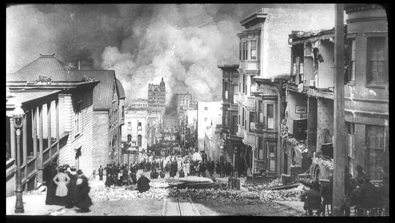
San Francisco burning. By Genthe, Arnold.
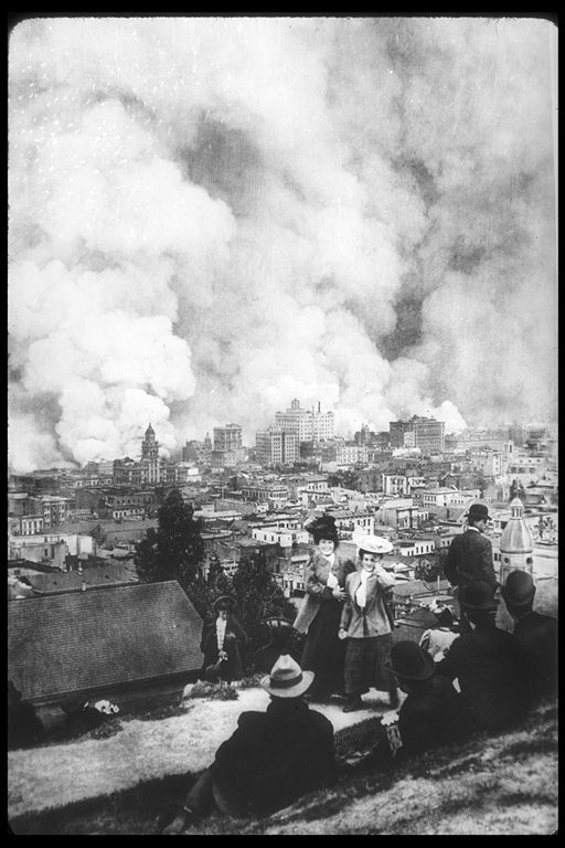
San Francisco burning. By Genthe, Arnold.
Images from the Steinbrugge Collection, Earthquake Engineering Research Center, University of California, Berkeley.
San Francisco Bay Area Quake Forecast
Mid-size earthquakes will soon rumble through the San Francisco area said Tousson Toppozada, of the California Department of Conservation, at the April 2000 annual meeting of the Seismological Society of America. He based his projection on the last two centuries of Bay Area quakes, including four major ones dating back to 1838. Toppozada could not say when or where specific earthquakes would occur, but he told the meeting to expect temblors in the range of 5.5 to 6.0 fairly soon.
Evidence for Large Earthquakes in Metropolitan Los Angeles
Various scientists speculate on whether the Los Angeles metropolitan area itself will be damaged significantly at some time in the future. . More specifically, what is the potential for significant damage from earthquakes along reverse faults in the Los Angeles region metropolitan area? [A reverse fault is one in which the dip of the fault plane is greater than 45 degrees, and the hanging wall moves upward relative to the footwall.] Sudden movements on reverse faults were responsible for the 1971 San Fernando, 1987 Whittier Narrows, 1991 Sierra Madre, and 1994 Northridge earthquakes.
C. Rubin and Others (1998, Science, v. 281, p. 398) present data bearing on reverse fault earthquake magnitudes from the Sierra Madre fault, one of the major reverse faults in the Los Angeles region. This fault has failed in magnitude 7.2 to 7.6 events at least twice in the past 15,000 years, and the quakes occurred only 12 miles northeast of downtown Los Angeles. Such quakes are far stronger than the deadly 1994 Northridge (M 6.7) quake that rocked Los Angeles, and their location is much closer to the millions of people living in the nation's most populous county. More telling, while the Northridge quake hurled much of its force northward, away from the metro region, a quake of 7 or greater on the Sierra Madre fault would rupture southward, directing energy toward the densely populated Los Angeles basin. A quake of the sort detected by Rubin and Others “would probably be the biggest event that this country has ever experienced in a major urban area,” said Thomas Henyey, director of the earthquake center at the University of Southern California. (USA Today. July 17, 1998).
Rubin and Others note that most earthquake hazard assessments in southern California have traditionally focused on the San Andreas fault and adjacent strike-slip faults. Unfortunately, large surface displacements and strong ground motions resulting from greater than magnitude 7 earthquakes within the Los Angeles region are not yet considered in most seismic hazard and risk assessments. Just imagine what such hazard and risk assessments might portend if pole-shift effects on the Los Angeles area faults would be included!
Goodnight Tokyo -- In May, 2001?
And Might a Mt. Fuji Eruption Follow?
On September 1, 1923, at one minute before noon local time, a great earthquake devastated southeastern Japan, including the cities of Tokyo (population of about 3 million) and Yokohama (population about 423 thousand). The earthquake had an estimated surface wave magnitude (Ms) of 8.19. Immediately after the shock numerous fires broke out in Tokyo and Yokohama. The city and harbor of Yokohama were entirely wrecked or burned. A large part of Tokyo shared the same fate. Loss of life was extraordinary, exceeding 140 thousand lives. Property damage was estimated to exceed one billion US dollars at the time.
“The biggest quake in over a century is threatening Japan's capital city,” says Peter Hadfield in the April 19, 2001, issue of the New Scientist Magazine. His article updates our own posting, Tokyo and Tokai, Japan, at the Brink (see Archives), which was based in part on earlier material from Hadfield.
Recall that Tokyo borders on the industrial area of Tokai to the southwest. Tokai earthquakes occur every 100-150 years along the plate boundary that runs through Suruga Bay. The last major quake was in 1854. Seismologists believe that stress that has built up along the Tokai fault line since 1854 could cause a quake up to M 8, which would be one of the largest in Japan in this century.
It seems that S. Matsumura, head of Tokyo's Advanced Seismicity Analysis Laboratory, believes that some of the stress between the Philippine Sea and Eurasian tectonic plates was relieved over the past few years, as indicated by the high number of small earthquakes (M1.5 or higher). But last October, the number of microquakes on the Eurasian plate was only about half the normal level. This happens when the Philippine Sea plate makes a sudden downward motion, but stops just before it triggers a large quake. Matsumura has found that a decrease in minor earthquake activity precedes earthquakes along other parts of Japan's east coast. And the data from instruments in the Suruga Bay area show that these slips are becoming increasingly frequent.
The interval between the first slip in October 1996 and August 1999 was 34months. The second slip came only 14 months later. Matsumura is expecting another slip in May, 2001. “Sooner or later one of these slips will turn into a major earthquake,” reports Hadfield. . One can only imagine what would happen if a pole shift were to begin and the rates of movement of all tectonic plates on Earth were to accelerate to varying degrees or in new directions.
Hadfield concludes his article with this observation regarding the volcano just west of Tokyo: “ Seismologists are also concerned about recent earthquakes under Mt. Fuji that suggest magma is rising. 'I think there's a relationship between volcanic activity at Mt. Fuji and earthquakes,' says Matsumura. 'There was a big earthquake in the Nankai in 1706 and a major eruption of Mt. Fuji in 1707.'”
Gauging Short-Term Volcanic Hazards at Popocatepetl
An article with this title appeared in the April 17, 2001, issue of Eos, the newspaper of the geophysical sciences. Popocatepetl, or Popo for short, is a giant volcano lying only 32 miles southeast of Mexico City, and 25 miles west of the city of Puebla. More than 30 million souls dwell in the combined metropolitan areas. It was during December 2000 that Popo reawakened, exhibiting violent explosions. Current dome growth and continuing explosive activity are producing difficulties for local civil authorities who need more information on how eruptions evolve at Popo. Four American and three Mexican volcanologists undertook, therefore, the job of bringing together available information relevant to short-term activities at Popo.
Large Plinian eruptions have occurred at Popo with intervals ranging from 1000 to 3000 years. A Plinian eruption is a high velocity explosion that shoots a huge column of pumice fragments up to 31 miles into the upper atmosphere. This happens when gas foams up in pasty magma below a volcano. Particles settle out hundreds of miles around. Nearby towns may be buried within hours under several feet of pumice fragments. Activity at Popo during the past 20,000 years included at least 7 large Plinian eruptions that produced extensive pumice/ash fallout, pyroclastic flows, and lahars. Recurrence of such a catastrophic Plinian eruption in the near future would represent a volcanic disaster of unprecedented dimensions.
Another hazard addressed by the authors is that of debris flows called lahars that occur when lava flows spill over Popo's crater margin and melt glacial ice that occurs at the top of the volcano. A lahar that occurred between 1,000 and 1,300 years ago traveled as far as 40 miles down a channel now inhabited by 30,000 people.
The present eruptive activity started on December 21, 1994, and the strongest explosion so far occurred on June 30, 1997, and not on December 18, 2000, as reported by the media. Considering past and current activity, it seems probable that domes will continue to grow until the crater is entirely filled with lava. The authors estimate that this might take at least a few more years at the current rate of dome emplacement. Once the crater is filled with lava, it will spill over the rim. But, they note, “A major eruption seems improbable at this time.”
But how do they know? Did they know when the current eruptive activity would commence? No. They are just guessing about future major eruptions, just as we are saying that the eruption of Popo and other torrid-area volcanoes matches Archangel Halaliel's statement that
There will be the upheavals in the Arctic and in the Antarctic that will make for the eruptions of volcanoes in the torrid areas, and there will be shifting then of the poles... And these will begin in those periods in '58 to '98, when these will be proclaimed as the periods when His light will be seen again in the clouds.
3976-15 January 19, 1934